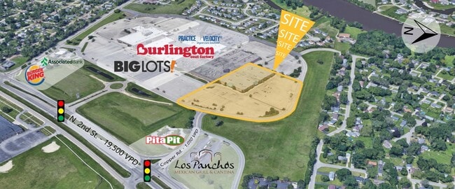
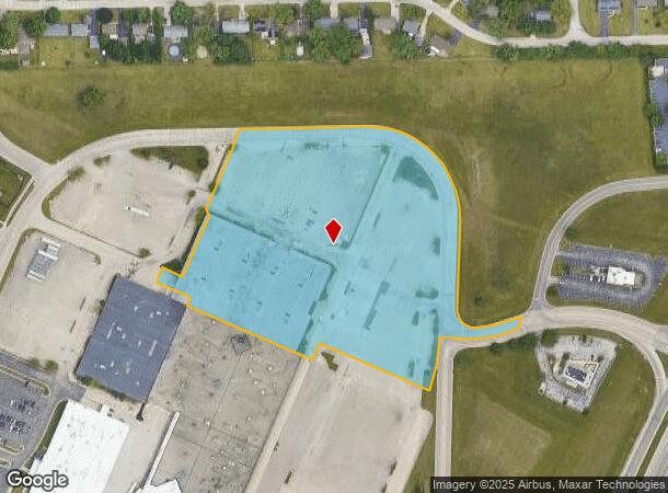
Property Record
8790 N 2Nd St, Machesney Park, IL 61115
NEARBY LISTINGS FOR SALE OR LEASE
-
-
View all Machesney Park listings for sale on LoopNet.com
Property Detail
8790 N 2Nd St
Rockford, IL
Machesney Park Mall Plat No 2
08-30-152-006
MACHESNEY PARK MALL PLAT NO 2 PT N1/2SEC 30-45-2 (EXC BEG SW COR LT 4 TH NE441.08 FT NE 325.41 FT E 180.69 FT SW228.42 FT SE 19.76 FT SW 175 FT NW 60
Commercialnec
Winnebago
X
Illinois
17201C0256E
4
2024
7.80 AC
2024
I-39 Corr/Winnebago Cnty
000101
Chicago
87,748 SF
DEMOGRAPHICS near 8790 N 2Nd St
1 Mile
3 Mile
5 Mile
2024 Total Population
7,854
37,158
100,663
2029 Population
7,768
36,543
99,008
Pop Growth 2024-2029
(1.09%)
(1.66%)
(1.64%)
Average Age
41
42
42
2024 Total Households
3,194
15,617
41,542
HH Growth 2024-2029
(1.16%)
(1.69%)
(1.68%)
Median Household Inc
$64,026
$58,147
$62,216
Avg Household Size
2.40
2.30
2.30
2024 Avg HH Vehicles
2.00
2.00
2.00
Median Home Value
$125,729
$134,917
$150,018
Median Year Built
1973
1974
1974
Nearby Places
Map Layers
Map Styles
 Street
 Aerial
- Restaurants
- Banks
- Shops
- Fitness
- Groceries
PUBLIC TRANSPORTATION
AIRPORT
Chicago/Rockford International
DRIVE
WALK
Distance
Chicago/Rockford International
28 min
15.4 mi
Freight Ports
Port Milwaukee
DRIVE
WALK
Distance
Port Milwaukee
105 min
87.1 mi
SALE & LEASE HISTORY
LISTING DATE
SALE/LEASE

Aug 16, 2018
For Sale
Nearby Properties
Address
Land Use
TOTAL SIZE
Lot Size
Zoning
Address
Land Use
TOTAL SIZE
Lot Size
Zoning
189,000 SF
56.75 AC
IL - INDUS
Address
Land Use
TOTAL SIZE
Lot Size
Zoning
105,664 SF
13.34 AC
Address
Land Use
TOTAL SIZE
Lot Size
Zoning
212,200 SF
21 AC
C3
Address
Land Use
TOTAL SIZE
Lot Size
Zoning
Address
Land Use
TOTAL SIZE
Lot Size
Zoning
51,580 SF
6.13 AC
Address
Land Use
TOTAL SIZE
Lot Size
Zoning
192,604 SF
17.05 AC
Address
Land Use
TOTAL SIZE
Lot Size
Zoning
112,035 SF
8.79 AC
Address
Land Use
TOTAL SIZE
Lot Size
Zoning
114,176 SF
4.94 AC
R4
Address
Land Use
TOTAL SIZE
Lot Size
Zoning
175,502 SF
18.15 AC
Address
Land Use
TOTAL SIZE
Lot Size
Zoning
Address
Land Use
TOTAL SIZE
Lot Size
Zoning
Address
Land Use
TOTAL SIZE
Lot Size
Zoning
125,024 SF
9.91 AC
Address
Land Use
TOTAL SIZE
Lot Size
Zoning
140,085 SF
14.90 AC
Address
Land Use
TOTAL SIZE
Lot Size
Zoning
124,757 SF
13.41 AC
Address
Land Use
TOTAL SIZE
Lot Size
Zoning
Address
Land Use
TOTAL SIZE
Lot Size
Zoning
13.45 AC
Address
Land Use
TOTAL SIZE
Lot Size
Zoning
16,500 SF
10.62 AC
Address
Land Use
TOTAL SIZE
Lot Size
Zoning
160,937 SF
10 AC
CR
Address
Land Use
TOTAL SIZE
Lot Size
Zoning
140,888 SF
7.96 AC
Address
Land Use
TOTAL SIZE
Lot Size
Zoning
243,057 SF
21.38 AC
C2
Address
Land Use
TOTAL SIZE
Lot Size
Zoning
103,326 SF
10.52 AC
Address
Land Use
TOTAL SIZE
Lot Size
Zoning
Address
Land Use
TOTAL SIZE
Lot Size
Zoning
82,582 SF
7.92 AC
CR
Address
Land Use
TOTAL SIZE
Lot Size
Zoning
135,351 SF
19 AC
Address
Land Use
TOTAL SIZE
Lot Size
Zoning
10.16 AC
Address
Land Use
TOTAL SIZE
Lot Size
Zoning
85,350 SF
13.15 AC
Address
Land Use
TOTAL SIZE
Lot Size
Zoning
119,108 SF
3.06 AC
R3
Address
Land Use
TOTAL SIZE
Lot Size
Zoning
55,200 SF
10.17 AC
Address
Land Use
TOTAL SIZE
Lot Size
Zoning
79,643 SF
3.55 AC
Address
Land Use
TOTAL SIZE
Lot Size
Zoning
The World's #1 Commercial Real Estate Marketplace
Connect with us
© 2026 CoStar Group
The information above has been obtained from sources believed reliable. While we do not doubt its accuracy we have not verified it and make no guarantee, warranty or representation about it. It is your responsibility to independently confirm its accuracy and completeness. Any projections, opinions, assumptions, or estimates used are for example only and do not represent the current or future performance of the property. The value of this transaction to you depends on tax and other factors which should be evaluated by your tax, financial, and legal advisors. You and your advisors should conduct a careful, independent investigation of the property to determine to your satisfaction the suitability of the property for your needs.