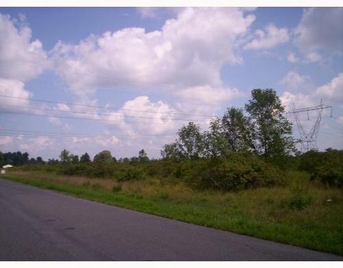
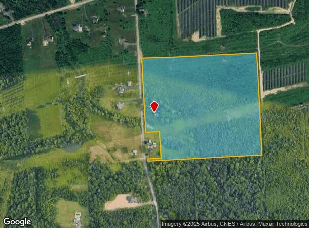
Property Record
8790 Van Hoesen Rd, Clay, NY 13041

NEARBY LISTINGS FOR SALE OR LEASE
Property Detail
8790 Van Hoesen Rd
Syracuse, NY
FL 26 1164743
312489-047-000-0001-003-000-0000
Onondaga
Miscresidentialimprovement
New York
X
3.000
36067C0083F
33.70 AC
2025
NE Outer Onondaga County
2024
Syracuse
011300
DEMOGRAPHICS near 8790 Van Hoesen Rd
1 Mile
3 Mile
5 Mile
2024 Total Population
533
15,375
76,325
2029 Population
526
14,848
74,309
Pop Growth 2024-2029
(1.31%)
(3.43%)
(2.64%)
Average Age
43
41
42
2024 Total Households
202
5,876
31,437
HH Growth 2024-2029
(1.49%)
(3.59%)
(2.81%)
Median Household Inc
$104,808
$104,260
$81,606
Avg Household Size
2.60
2.60
2.40
2024 Avg HH Vehicles
2.00
2.00
2.00
Median Home Value
$241,250
$199,049
$175,540
Median Year Built
1980
1985
1977
Nearby Places
- Restaurants
- Banks
- Shops
- Fitness
- Groceries
PUBLIC TRANSPORTATION
AIRPORT
Syracuse Hancock International
DRIVE
WALK
Distance
Syracuse Hancock International
17 min
10.6 mi
Freight Ports
Albany, NY Port
DRIVE
WALK
Distance
Albany, NY Port
181 min
150.9 mi
Nearby Properties
Address
Land Use
TOTAL SIZE
Lot Size
Zoning
Address
Land Use
TOTAL SIZE
Lot Size
Zoning
8,417 SF
13.95 AC
Address
Land Use
TOTAL SIZE
Lot Size
Zoning
1,568 SF
330.36 AC
Address
Land Use
TOTAL SIZE
Lot Size
Zoning
16,630 SF
10.16 AC
Address
Land Use
TOTAL SIZE
Lot Size
Zoning
116,020 SF
15.72 AC
PUD
Address
Land Use
TOTAL SIZE
Lot Size
Zoning
42,210 SF
62.23 AC
N00
Address
Land Use
TOTAL SIZE
Lot Size
Zoning
16,630 SF
2.66 AC
Address
Land Use
TOTAL SIZE
Lot Size
Zoning
16,630 SF
3.95 AC
Address
Land Use
TOTAL SIZE
Lot Size
Zoning
17,760 SF
4.54 AC
CG
Address
Land Use
TOTAL SIZE
Lot Size
Zoning
8,068 SF
3.33 AC
Address
Land Use
TOTAL SIZE
Lot Size
Zoning
12,585 SF
6.58 AC
Address
Land Use
TOTAL SIZE
Lot Size
Zoning
21,224 SF
3 AC
CG
Address
Land Use
TOTAL SIZE
Lot Size
Zoning
51,294 SF
6.25 AC
Address
Land Use
TOTAL SIZE
Lot Size
Zoning
10,540 SF
4.59 AC
CG
Address
Land Use
TOTAL SIZE
Lot Size
Zoning
6,200 SF
117.28 AC
06 - INDUS
Address
Land Use
TOTAL SIZE
Lot Size
Zoning
Address
Land Use
TOTAL SIZE
Lot Size
Zoning
13,844 SF
3.49 AC
Address
Land Use
TOTAL SIZE
Lot Size
Zoning
7,200 SF
71.08 AC
Address
Land Use
TOTAL SIZE
Lot Size
Zoning
12,312 SF
40.32 AC
05 - COMME
Address
Land Use
TOTAL SIZE
Lot Size
Zoning
54,523 SF
4.72 AC
Address
Land Use
TOTAL SIZE
Lot Size
Zoning
864 SF
98.47 AC
01 - NOT Z
Address
Land Use
TOTAL SIZE
Lot Size
Zoning
62,496 SF
26.34 AC
04 - FARM
Address
Land Use
TOTAL SIZE
Lot Size
Zoning
3,776 SF
1.50 AC
MR
Address
Land Use
TOTAL SIZE
Lot Size
Zoning
10,500 SF
8.39 AC
Address
Land Use
TOTAL SIZE
Lot Size
Zoning
10,640 SF
5.67 AC
CG
Address
Land Use
TOTAL SIZE
Lot Size
Zoning
10,560 SF
8.23 AC
Address
Land Use
TOTAL SIZE
Lot Size
Zoning
2,715 SF
2.72 AC
Address
Land Use
TOTAL SIZE
Lot Size
Zoning
14,800 SF
7.79 AC
Address
Land Use
TOTAL SIZE
Lot Size
Zoning
13,880 SF
13.78 AC
Address
Land Use
TOTAL SIZE
Lot Size
Zoning
26,130 SF
8.36 AC
Address
Land Use
TOTAL SIZE
Lot Size
Zoning
183,715 SF
18.21 AC
05 - COMME
The World's #1 Commercial Real Estate Marketplace
Connect with us
© 2025 CoStar Group
The information above has been obtained from sources believed reliable. While we do not doubt its accuracy we have not verified it and make no guarantee, warranty or representation about it. It is your responsibility to independently confirm its accuracy and completeness. Any projections, opinions, assumptions, or estimates used are for example only and do not represent the current or future performance of the property. The value of this transaction to you depends on tax and other factors which should be evaluated by your tax, financial, and legal advisors. You and your advisors should conduct a careful, independent investigation of the property to determine to your satisfaction the suitability of the property for your needs.