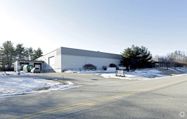
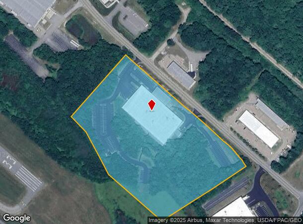
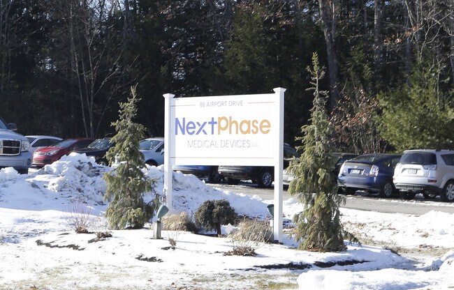
Property Record
88 Airport Dr, Rochester, NH 03867
NEARBY LISTINGS FOR SALE OR LEASE
Property Detail
88 Airport Dr
Manufacturinglight
Strafford
X
New Hampshire
23031C0516G
10.84 AC
2024
Strafford County
2024
Boston
084100
Boston-Cambridge-Newton, MA-NH
61,025 SF
RCHE-000243-000019
DEMOGRAPHICS near 88 Airport Dr
1 Mile
3 Mile
5 Mile
2024 Total Population
539
18,653
54,457
2029 Population
554
19,500
57,041
Pop Growth 2024-2029
+ 2.78%
+ 4.54%
+ 4.75%
Average Age
43
44
42
2024 Total Households
207
7,844
22,415
HH Growth 2024-2029
+ 2.90%
+ 4.60%
+ 4.83%
Median Household Inc
$100,987
$79,742
$86,247
Avg Household Size
2.40
2.30
2.40
2024 Avg HH Vehicles
2.00
2.00
2.00
Median Home Value
$289,422
$255,435
$264,474
Median Year Built
1988
1980
1977
Nearby Places
- Restaurants
- Banks
- Shops
- Fitness
- Groceries
PUBLIC TRANSPORTATION
COMMUTER RAIL
DRIVE
WALK
Distance
17 min
7.0 mi
AIRPORT
Portsmouth International at Pease
DRIVE
WALK
Distance
Portsmouth International at Pease
32 min
17.2 mi
SALE & LEASE HISTORY
LISTING DATE
SALE/LEASE

Oct 02, 2018
For Lease
Nearby Properties
Address
Land Use
TOTAL SIZE
Lot Size
Zoning
Address
Land Use
TOTAL SIZE
Lot Size
Zoning
50.50 AC
R2
Address
Land Use
TOTAL SIZE
Lot Size
Zoning
345,277 SF
49.30 AC
IND
Address
Land Use
TOTAL SIZE
Lot Size
Zoning
219,360 SF
6.23 AC
HSP
Address
Land Use
TOTAL SIZE
Lot Size
Zoning
428,428 SF
210.42 AC
CI
Address
Land Use
TOTAL SIZE
Lot Size
Zoning
1,273 SF
29.90 AC
R2
Address
Land Use
TOTAL SIZE
Lot Size
Zoning
77,916 SF
6.58 AC
A
Address
Land Use
TOTAL SIZE
Lot Size
Zoning
2.41 AC
Address
Land Use
TOTAL SIZE
Lot Size
Zoning
49,146 SF
7.10 AC
R2
Address
Land Use
TOTAL SIZE
Lot Size
Zoning
150,000 SF
29.85 AC
IND
Address
Land Use
TOTAL SIZE
Lot Size
Zoning
46.98 AC
CI
Address
Land Use
TOTAL SIZE
Lot Size
Zoning
59,160 SF
10.44 AC
R1
Address
Land Use
TOTAL SIZE
Lot Size
Zoning
33.57 AC
CI
Address
Land Use
TOTAL SIZE
Lot Size
Zoning
4,916 SF
93 AC
A
Address
Land Use
TOTAL SIZE
Lot Size
Zoning
12 AC
R2
Address
Land Use
TOTAL SIZE
Lot Size
Zoning
82,752 SF
9.88 AC
R2
Address
Land Use
TOTAL SIZE
Lot Size
Zoning
44,530 SF
2.03 AC
A
Address
Land Use
TOTAL SIZE
Lot Size
Zoning
44,530 SF
5.67 AC
A
Address
Land Use
TOTAL SIZE
Lot Size
Zoning
90,112 SF
7.88 AC
CI
Address
Land Use
TOTAL SIZE
Lot Size
Zoning
289 AC
IND
Address
Land Use
TOTAL SIZE
Lot Size
Zoning
40,091 SF
5.12 AC
A
Address
Land Use
TOTAL SIZE
Lot Size
Zoning
40,091 SF
1.85 AC
A
Address
Land Use
TOTAL SIZE
Lot Size
Zoning
195,757 SF
27.47 AC
IND
Address
Land Use
TOTAL SIZE
Lot Size
Zoning
40,567 SF
20.50 AC
R2
Address
Land Use
TOTAL SIZE
Lot Size
Zoning
3.87 AC
CI
Address
Land Use
TOTAL SIZE
Lot Size
Zoning
55,696 SF
174 AC
AS
Address
Land Use
TOTAL SIZE
Lot Size
Zoning
132,235 SF
12.88 AC
IND
Address
Land Use
TOTAL SIZE
Lot Size
Zoning
32,829 SF
5.19 AC
CI
Address
Land Use
TOTAL SIZE
Lot Size
Zoning
44,272 SF
27 AC
A
Address
Land Use
TOTAL SIZE
Lot Size
Zoning
16,680 SF
9.84 AC
CI
Address
Land Use
TOTAL SIZE
Lot Size
Zoning
57,340 SF
5.25 AC
CI
The World's #1 Commercial Real Estate Marketplace
Connect with us
© 2025 CoStar Group
The information above has been obtained from sources believed reliable. While we do not doubt its accuracy we have not verified it and make no guarantee, warranty or representation about it. It is your responsibility to independently confirm its accuracy and completeness. Any projections, opinions, assumptions, or estimates used are for example only and do not represent the current or future performance of the property. The value of this transaction to you depends on tax and other factors which should be evaluated by your tax, financial, and legal advisors. You and your advisors should conduct a careful, independent investigation of the property to determine to your satisfaction the suitability of the property for your needs.