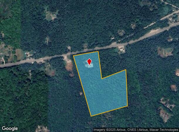
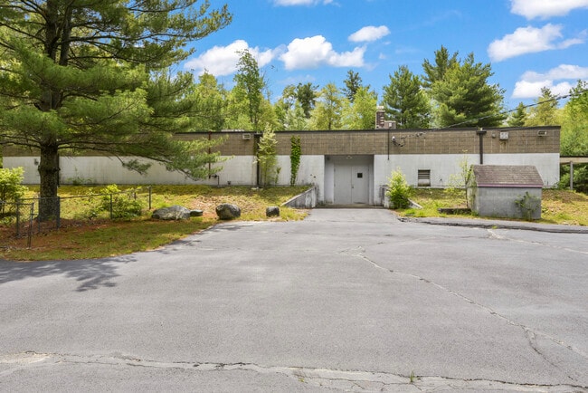
Property Record
88 Danielson Pike, Foster, RI 02825

Current Lease Availabilities
NEARBY LISTINGS FOR SALE OR LEASE
-
-
View all Foster listings for lease on LoopNet.com
Property Detail
88 Danielson Pike
FOST-000014-000000-000098
Providence
Industrialgeneral
Rhode Island
X
98
44007C0255G
19.36 AC
2024
Foster/Scituate
2024
Providence
013300
Providence-Warwick, RI-MA
6,784 SF
DEMOGRAPHICS near 88 Danielson Pike
1 Mile
3 Mile
5 Mile
2024 Total Population
337
2,604
8,799
2029 Population
325
2,537
8,708
Pop Growth 2024-2029
(3.56%)
(2.57%)
(1.03%)
Average Age
45
45
45
2024 Total Households
132
1,024
3,446
HH Growth 2024-2029
(3.79%)
(2.73%)
(1.13%)
Median Household Inc
$110,000
$106,967
$97,880
Avg Household Size
2.50
2.50
2.50
2024 Avg HH Vehicles
2.00
2.00
2.00
Median Home Value
$392,045
$383,879
$370,593
Median Year Built
1966
1969
1973
Nearby Places
Map Layers
Map Styles
 Street
 Aerial
- Restaurants
- Banks
- Shops
- Fitness
- Groceries
PUBLIC TRANSPORTATION
AIRPORT
Rhode Island Tf Green International
DRIVE
WALK
Distance
Rhode Island Tf Green International
31 min
22.6 mi
Freight Ports
Port of Davisville, RI
DRIVE
WALK
Distance
Port of Davisville, RI
43 min
31.9 mi
Nearby Properties
Address
Land Use
TOTAL SIZE
Lot Size
Zoning
Address
Land Use
TOTAL SIZE
Lot Size
Zoning
50,170 SF
17.22 AC
30
Address
Land Use
TOTAL SIZE
Lot Size
Zoning
482 AC
30
Address
Land Use
TOTAL SIZE
Lot Size
Zoning
9,068 SF
40.01 AC
RR-1
Address
Land Use
TOTAL SIZE
Lot Size
Zoning
2,386 SF
19 AC
20
Address
Land Use
TOTAL SIZE
Lot Size
Zoning
196 AC
30
Address
Land Use
TOTAL SIZE
Lot Size
Zoning
161.15 AC
30
Address
Land Use
TOTAL SIZE
Lot Size
Zoning
5,025 SF
26.87 AC
70
Address
Land Use
TOTAL SIZE
Lot Size
Zoning
4,528 SF
7.10 AC
1
Address
Land Use
TOTAL SIZE
Lot Size
Zoning
120 AC
30
Address
Land Use
TOTAL SIZE
Lot Size
Zoning
9,828 SF
10.16 AC
1
Address
Land Use
TOTAL SIZE
Lot Size
Zoning
48 AC
30
Address
Land Use
TOTAL SIZE
Lot Size
Zoning
5,108 SF
4.56 AC
BG
Address
Land Use
TOTAL SIZE
Lot Size
Zoning
7,732 SF
14 AC
30
Address
Land Use
TOTAL SIZE
Lot Size
Zoning
6,820 SF
1.50 AC
20
Address
Land Use
TOTAL SIZE
Lot Size
Zoning
5,562 SF
0.14 AC
30
Address
Land Use
TOTAL SIZE
Lot Size
Zoning
80 AC
30
Address
Land Use
TOTAL SIZE
Lot Size
Zoning
78.71 AC
30
Address
Land Use
TOTAL SIZE
Lot Size
Zoning
4.31 AC
RS-1
Address
Land Use
TOTAL SIZE
Lot Size
Zoning
1,410 SF
31.59 AC
30
Address
Land Use
TOTAL SIZE
Lot Size
Zoning
1,161 SF
6.10 AC
1
Address
Land Use
TOTAL SIZE
Lot Size
Zoning
1,696 SF
5 AC
1
Address
Land Use
TOTAL SIZE
Lot Size
Zoning
1,638 SF
2.75 AC
30
Address
Land Use
TOTAL SIZE
Lot Size
Zoning
10.39 AC
RR-1
Address
Land Use
TOTAL SIZE
Lot Size
Zoning
2,497 SF
62.20 AC
30
Address
Land Use
TOTAL SIZE
Lot Size
Zoning
12,108 SF
1.08 AC
BL V
Address
Land Use
TOTAL SIZE
Lot Size
Zoning
4,208 SF
0.50 AC
30
Address
Land Use
TOTAL SIZE
Lot Size
Zoning
1,560 SF
0.64 AC
30
Address
Land Use
TOTAL SIZE
Lot Size
Zoning
2,559 SF
6.62 AC
30
Address
Land Use
TOTAL SIZE
Lot Size
Zoning
768 SF
5.30 AC
1
Address
Land Use
TOTAL SIZE
Lot Size
Zoning
1,875 SF
32.14 AC
30
The World's #1 Commercial Real Estate Marketplace
Connect with us
© 2025 CoStar Group
The information above has been obtained from sources believed reliable. While we do not doubt its accuracy we have not verified it and make no guarantee, warranty or representation about it. It is your responsibility to independently confirm its accuracy and completeness. Any projections, opinions, assumptions, or estimates used are for example only and do not represent the current or future performance of the property. The value of this transaction to you depends on tax and other factors which should be evaluated by your tax, financial, and legal advisors. You and your advisors should conduct a careful, independent investigation of the property to determine to your satisfaction the suitability of the property for your needs.