Property Record
88 Nesbitt Dr, Holley, NY 14470


NEARBY LISTINGS FOR SALE OR LEASE
-
-
View all Holley listings for sale on LoopNet.com
Property Detail
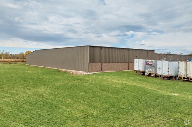
88 Nesbitt Dr
343201-087-007-0002-020-000
Orleans
Manufacturinglight
New York
X
20.000
36073C0331D
5.52 AC
2025
Orleans County
2024
Rochester
040802
Rochester, NY
87,000 SF
DEMOGRAPHICS near 88 Nesbitt Dr
1 Mile
3 Mile
5 Mile
2024 Total Population
1,983
5,663
14,604
2029 Population
1,948
5,562
14,388
Pop Growth 2024-2029
(1.77%)
(1.78%)
(1.48%)
Average Age
41
42
39
2024 Total Households
875
2,425
5,475
HH Growth 2024-2029
(1.94%)
(1.98%)
(1.59%)
Median Household Inc
$59,040
$57,919
$55,621
Avg Household Size
2.30
2.30
2.30
2024 Avg HH Vehicles
2.00
2.00
2.00
Median Home Value
$112,409
$126,935
$140,535
Median Year Built
1948
1965
1972
Nearby Places
Map Layers
Map Styles
 Street
 Aerial
- Restaurants
- Banks
- Shops
- Fitness
- Groceries
PUBLIC TRANSPORTATION
AIRPORT
Frederick Douglass/Greater Rochester International
DRIVE
WALK
Distance
Frederick Douglass/Greater Rochester International
32 min
25.3 mi
Freight Ports
Albany, NY Port
DRIVE
WALK
Distance
Albany, NY Port
297 min
251.5 mi
Nearby Properties
Address
Land Use
TOTAL SIZE
Lot Size
Zoning
Address
Land Use
TOTAL SIZE
Lot Size
Zoning
116,529 SF
28.90 AC
01 - NOT Z
Address
Land Use
TOTAL SIZE
Lot Size
Zoning
924 SF
101.70 AC
BC
Address
Land Use
TOTAL SIZE
Lot Size
Zoning
54,000 SF
1.10 AC
C1
Address
Land Use
TOTAL SIZE
Lot Size
Zoning
34,810 SF
13.10 AC
R1
Address
Land Use
TOTAL SIZE
Lot Size
Zoning
1,200 SF
39.40 AC
05 - COMME
Address
Land Use
TOTAL SIZE
Lot Size
Zoning
46,065 SF
12.20 AC
R1
Address
Land Use
TOTAL SIZE
Lot Size
Zoning
30.50 AC
BC
Address
Land Use
TOTAL SIZE
Lot Size
Zoning
212,509 SF
4.45 AC
C1
Address
Land Use
TOTAL SIZE
Lot Size
Zoning
2,235 SF
16.20 AC
C1
Address
Land Use
TOTAL SIZE
Lot Size
Zoning
10,080 SF
5 AC
02 - SINGL
Address
Land Use
TOTAL SIZE
Lot Size
Zoning
59,095 SF
45.85 AC
C1
Address
Land Use
TOTAL SIZE
Lot Size
Zoning
47,200 SF
4.80 AC
M1
Address
Land Use
TOTAL SIZE
Lot Size
Zoning
10,368 SF
43.26 AC
C1
Address
Land Use
TOTAL SIZE
Lot Size
Zoning
9,590 SF
391.70 AC
BUSIN
Address
Land Use
TOTAL SIZE
Lot Size
Zoning
9,744 SF
7.60 AC
R1
Address
Land Use
TOTAL SIZE
Lot Size
Zoning
22,584 SF
8.20 AC
A
Address
Land Use
TOTAL SIZE
Lot Size
Zoning
33,000 SF
3.82 AC
A
Address
Land Use
TOTAL SIZE
Lot Size
Zoning
78.10 AC
BUSIN
Address
Land Use
TOTAL SIZE
Lot Size
Zoning
9,120 SF
9.10 AC
BUSIN
Address
Land Use
TOTAL SIZE
Lot Size
Zoning
4,800 SF
6.20 AC
BC
Address
Land Use
TOTAL SIZE
Lot Size
Zoning
11,760 SF
1.02 AC
R1
Address
Land Use
TOTAL SIZE
Lot Size
Zoning
1,792 SF
62.90 AC
BUSIN
Address
Land Use
TOTAL SIZE
Lot Size
Zoning
24.39 AC
Address
Land Use
TOTAL SIZE
Lot Size
Zoning
69.70 AC
02 - SINGL
Address
Land Use
TOTAL SIZE
Lot Size
Zoning
9,792 SF
21.92 AC
RA
Address
Land Use
TOTAL SIZE
Lot Size
Zoning
8,352 SF
0.75 AC
C1
Address
Land Use
TOTAL SIZE
Lot Size
Zoning
68,061 SF
5.36 AC
C1
Address
Land Use
TOTAL SIZE
Lot Size
Zoning
20,160 SF
11.60 AC
BUSIN
Address
Land Use
TOTAL SIZE
Lot Size
Zoning
4,981 SF
0.87 AC
R2
The World's #1 Commercial Real Estate Marketplace
Connect with us
© 2026 CoStar Group
The information above has been obtained from sources believed reliable. While we do not doubt its accuracy we have not verified it and make no guarantee, warranty or representation about it. It is your responsibility to independently confirm its accuracy and completeness. Any projections, opinions, assumptions, or estimates used are for example only and do not represent the current or future performance of the property. The value of this transaction to you depends on tax and other factors which should be evaluated by your tax, financial, and legal advisors. You and your advisors should conduct a careful, independent investigation of the property to determine to your satisfaction the suitability of the property for your needs.