Property Record
88 Post Rd W, Westport, CT 06880

Save to a Folder
{{folder.Name}}
{{folder.ListingIds.length}} Properties
{{folder.ListingIds.length}} Property
Create a New Folder
Current Lease Availabilities
Property Detail
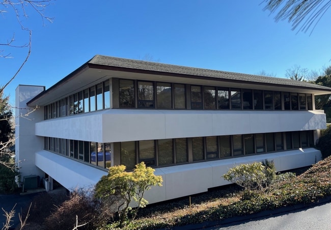
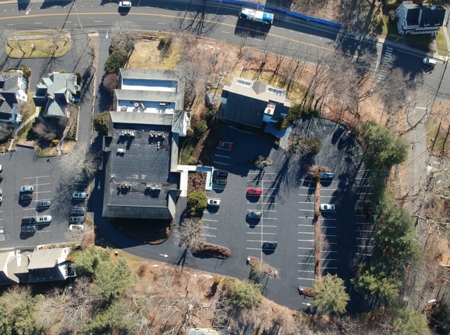
88 Post Rd W
WPOR-000009C-000000-000062
Western Ct
Commercialbuilding
Connecticut
RORD1
62-0
B and X Area of moderate flood hazard, usually the area between the limits of the 100-year and 500-year floods.
1.67 AC
2025
Westport
2025
Westchester/So Connecticut
050100
Bridgeport-Stamford-Danbury, CT
19,930 SF
NEARBY LISTINGS FOR SALE OR LEASE
DEMOGRAPHICS near 88 Post Rd W
1 mile
3 mile
5 mile
2025 Total Population
6,003
55,235
132,317
2030 Population
6,206
56,632
135,453
Pop Growth 2025-2030
+ 3.38%
+ 2.53%
+ 2.37%
Average Age
43
43
42
2025 Total Households
2,185
20,903
50,356
HH Growth 2025-2030
+ 3.34%
+ 2.46%
+ 2.41%
Median Household Inc
$227,466
$151,843
$127,342
Avg Household Size
2.70
2.60
2.60
2025 Avg HH Vehicles
2.00
2.00
2.00
Median Home Value
$1,087,520
$868,269
$799,620
Median Year Built
1965
1965
1967
Nearby Places
Map Layers
Map Styles
 Street
 Aerial
Layers
 Traffic
 Biking
Places
Listings with unknown addresses are not visible on the map
- Restaurants
- Banks
- Shops
- Fitness
- Groceries
PUBLIC TRANSPORTATION
COMMUTER RAIL
Westport Station (New Haven Line - Metro-North Commuter Railroad Company (Metro-North))
Drive
Walk
Distance
Westport Station (New Haven Line - Metro-North Commuter Railroad Company (Metro-North))
5 min
2.0 mi
East Norwalk Station (New Haven Line - Metro-North Commuter Railroad Company (Metro-North))
Drive
Walk
Distance
East Norwalk Station (New Haven Line - Metro-North Commuter Railroad Company (Metro-North))
6 min
3.6 mi
AIRPORT
Westchester County
Drive
Walk
Distance
Westchester County
38 min
25.1 mi
Tweed/New Haven
Drive
Walk
Distance
Tweed/New Haven
52 min
34.0 mi
Freight Ports
Port of New Haven
Drive
Walk
Distance
Port of New Haven
47 min
31.1 mi
Nearby Properties
Address
Land Use
TOTAL SIZE
Lot Size
Zoning
Address
Land Use
TOTAL SIZE
Lot Size
Zoning
50.42 AC
DDD4
Address
Land Use
TOTAL SIZE
Lot Size
Zoning
6.80 AC
B2
Address
Land Use
TOTAL SIZE
Lot Size
Zoning
226,920 SF
24.75 AC
B
Address
Land Use
TOTAL SIZE
Lot Size
Zoning
4.44 AC
CBDB
Address
Land Use
TOTAL SIZE
Lot Size
Zoning
27.33 AC
AAA
Address
Land Use
TOTAL SIZE
Lot Size
Zoning
269,100 SF
38.37 AC
RI
Address
Land Use
TOTAL SIZE
Lot Size
Zoning
252,316 SF
Address
Land Use
TOTAL SIZE
Lot Size
Zoning
1.44 AC
BCD/H
Address
Land Use
TOTAL SIZE
Lot Size
Zoning
101,688 SF
5 AC
RI
Address
Land Use
TOTAL SIZE
Lot Size
Zoning
272.25 AC
AAA
Address
Land Use
TOTAL SIZE
Lot Size
Zoning
13.46 AC
RB
Address
Land Use
TOTAL SIZE
Lot Size
Zoning
13.10 AC
RBD
Address
Land Use
TOTAL SIZE
Lot Size
Zoning
29.50 AC
DOSRD1
Address
Land Use
TOTAL SIZE
Lot Size
Zoning
23.15 AC
A
Address
Land Use
TOTAL SIZE
Lot Size
Zoning
12.30 AC
AA
Address
Land Use
TOTAL SIZE
Lot Size
Zoning
165,384 SF
18.78 AC
B
Address
Land Use
TOTAL SIZE
Lot Size
Zoning
168.95 AC
AAA_AA
Address
Land Use
TOTAL SIZE
Lot Size
Zoning
23.87 AC
A
Address
Land Use
TOTAL SIZE
Lot Size
Zoning
24.82 AC
AA_A
Address
Land Use
TOTAL SIZE
Lot Size
Zoning
90,056 SF
28.10 AC
AA_A
Address
Land Use
TOTAL SIZE
Lot Size
Zoning
20.91 AC
A1
Address
Land Use
TOTAL SIZE
Lot Size
Zoning
37.21 AC
RI
Address
Land Use
TOTAL SIZE
Lot Size
Zoning
10.55 AC
AA
Address
Land Use
TOTAL SIZE
Lot Size
Zoning
54,143 SF
2.75 AC
B
Address
Land Use
TOTAL SIZE
Lot Size
Zoning
7.13 AC
B
Address
Land Use
TOTAL SIZE
Lot Size
Zoning
94,449 SF
5.40 AC
BPD/A
Address
Land Use
TOTAL SIZE
Lot Size
Zoning
81,640 SF
7.53 AC
B2
Address
Land Use
TOTAL SIZE
Lot Size
Zoning
10.37 AC
B2
Address
Land Use
TOTAL SIZE
Lot Size
Zoning
118,795 SF
15.60 AC
B2
Address
Land Use
TOTAL SIZE
Lot Size
Zoning
21.93 AC
DDD4
The World's #1 Commercial Real Estate Marketplace
Connect with us
© 2026 CoStar Group
The information above has been obtained from sources believed reliable. While we do not doubt its accuracy we have not verified it and make no guarantee, warranty or representation about it. It is your responsibility to independently confirm its accuracy and completeness. Any projections, opinions, assumptions, or estimates used are for example only and do not represent the current or future performance of the property. The value of this transaction to you depends on tax and other factors which should be evaluated by your tax, financial, and legal advisors. You and your advisors should conduct a careful, independent investigation of the property to determine to your satisfaction the suitability of the property for your needs.