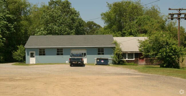
Property Record
88 Providence St, Rehoboth, MA 02769

Save to a Folder
{{folder.Name}}
{{folder.ListingIds.length}} Properties
{{folder.ListingIds.length}} Property
Create a New Folder
Property Detail
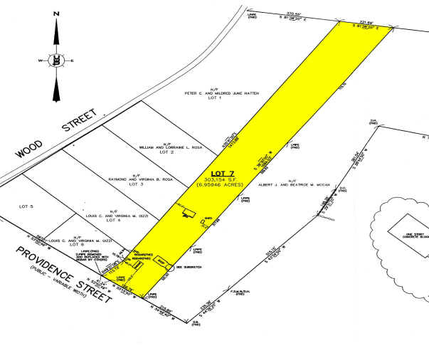
88 Providence St
REHO-000014-000000-000053
Bristol
Commercialofficeresidentialmixeduse
Massachusetts
AE The base floodplain where base flood elevations are provided. AE Zones are now used on new format FIRMs instead of A1-A30 Zones.
7.21 AC
2025
Attleboro/New Bedford
2025
Boston
633200
Providence-Warwick, RI-MA
NEARBY LISTINGS FOR SALE OR LEASE
DEMOGRAPHICS near 88 Providence St
1 mile
3 mile
5 mile
2025 Total Population
803
11,606
53,500
2030 Population
823
11,903
54,482
Pop Growth 2025-2030
+ 2.49%
+ 2.56%
+ 1.84%
Average Age
44
44
43
2025 Total Households
290
4,165
20,580
HH Growth 2025-2030
+ 2.76%
+ 2.62%
+ 1.79%
Median Household Inc
$151,500
$133,507
$111,258
Avg Household Size
2.70
2.70
2.60
2025 Avg HH Vehicles
3.00
2.00
2.00
Median Home Value
$616,013
$562,123
$499,999
Median Year Built
1983
1979
1968
Nearby Places
Map Layers
Map Styles
 Street
 Aerial
Layers
 Traffic
 Biking
Places
Listings with unknown addresses are not visible on the map
- Restaurants
- Banks
- Shops
- Fitness
- Groceries
PUBLIC TRANSPORTATION
COMMUTER RAIL
Providence (Providence/Stoughton Line - Massachusetts Bay Transportation Authority Commuter Rail (Purple Line))
Drive
Walk
Distance
Providence (Providence/Stoughton Line - Massachusetts Bay Transportation Authority Commuter Rail (Purple Line))
18 min
9.1 mi
AIRPORT
Rhode Island Tf Green International
Drive
Walk
Distance
Rhode Island Tf Green International
31 min
15.9 mi
Freight Ports
Port of Davisville, RI
Drive
Walk
Distance
Port of Davisville, RI
47 min
28.3 mi
Nearby Properties
Address
Land Use
TOTAL SIZE
Lot Size
Zoning
Address
Land Use
TOTAL SIZE
Lot Size
Zoning
248,000 SF
75.88 AC
I
Address
Land Use
TOTAL SIZE
Lot Size
Zoning
179,889 SF
17.96 AC
C
Address
Land Use
TOTAL SIZE
Lot Size
Zoning
71,585 SF
26.71 AC
R1
Address
Land Use
TOTAL SIZE
Lot Size
Zoning
36,188 SF
65 AC
R1
Address
Land Use
TOTAL SIZE
Lot Size
Zoning
76,763 SF
12.60 AC
Address
Land Use
TOTAL SIZE
Lot Size
Zoning
13,314 SF
1.73 AC
C
Address
Land Use
TOTAL SIZE
Lot Size
Zoning
39,809 SF
4.80 AC
C
Address
Land Use
TOTAL SIZE
Lot Size
Zoning
178 AC
Address
Land Use
TOTAL SIZE
Lot Size
Zoning
5,800 SF
4.35 AC
C
Address
Land Use
TOTAL SIZE
Lot Size
Zoning
13,572 SF
4.96 AC
R1
Address
Land Use
TOTAL SIZE
Lot Size
Zoning
38,920 SF
30.31 AC
R2
Address
Land Use
TOTAL SIZE
Lot Size
Zoning
29,742 SF
5.50 AC
C
Address
Land Use
TOTAL SIZE
Lot Size
Zoning
20,910 SF
9.69 AC
I
Address
Land Use
TOTAL SIZE
Lot Size
Zoning
2,400 SF
4.50 AC
R1
Address
Land Use
TOTAL SIZE
Lot Size
Zoning
20,879 SF
2.22 AC
R1
Address
Land Use
TOTAL SIZE
Lot Size
Zoning
5,004 SF
200.90 AC
R1
Address
Land Use
TOTAL SIZE
Lot Size
Zoning
814 SF
15.95 AC
I
Address
Land Use
TOTAL SIZE
Lot Size
Zoning
14,430 SF
20.30 AC
Address
Land Use
TOTAL SIZE
Lot Size
Zoning
36,910 SF
3.38 AC
I
Address
Land Use
TOTAL SIZE
Lot Size
Zoning
19,200 SF
2.10 AC
MUR3
Address
Land Use
TOTAL SIZE
Lot Size
Zoning
26,720 SF
4.18 AC
C
Address
Land Use
TOTAL SIZE
Lot Size
Zoning
6.99 AC
Address
Land Use
TOTAL SIZE
Lot Size
Zoning
20,960 SF
1.94 AC
C
Address
Land Use
TOTAL SIZE
Lot Size
Zoning
28,216 SF
5.57 AC
I
Address
Land Use
TOTAL SIZE
Lot Size
Zoning
22,992 SF
14.11 AC
C
Address
Land Use
TOTAL SIZE
Lot Size
Zoning
6,328 SF
166.51 AC
Address
Land Use
TOTAL SIZE
Lot Size
Zoning
33,204 SF
20 AC
C
Address
Land Use
TOTAL SIZE
Lot Size
Zoning
22,610 SF
3.70 AC
C
Address
Land Use
TOTAL SIZE
Lot Size
Zoning
12,300 SF
16 AC
R1
Address
Land Use
TOTAL SIZE
Lot Size
Zoning
22,704 SF
1.31 AC
C
The World's #1 Commercial Real Estate Marketplace
Connect with us
© 2026 CoStar Group
The information above has been obtained from sources believed reliable. While we do not doubt its accuracy we have not verified it and make no guarantee, warranty or representation about it. It is your responsibility to independently confirm its accuracy and completeness. Any projections, opinions, assumptions, or estimates used are for example only and do not represent the current or future performance of the property. The value of this transaction to you depends on tax and other factors which should be evaluated by your tax, financial, and legal advisors. You and your advisors should conduct a careful, independent investigation of the property to determine to your satisfaction the suitability of the property for your needs.