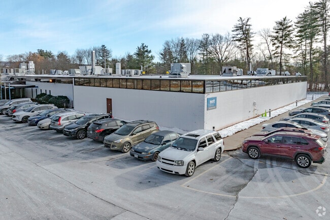
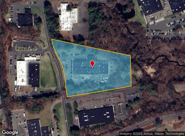
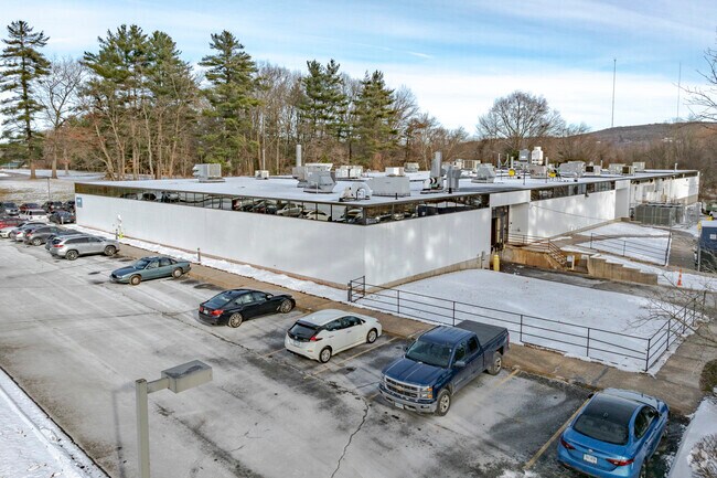
Property Record
88 Spring St, Plainville, CT 06062
NEARBY LISTINGS FOR SALE OR LEASE
Property Detail
88 Spring St
PLAI-000003-B000000-000001
Hartford
Industrialgeneral
Connecticut
AE
1
09003C0478F
6.50 AC
2025
Plainville
2025
Hartford
420500
Hartford-West Hartford-East Hartford, CT
49,128 SF
DEMOGRAPHICS near 88 Spring St
1 Mile
3 Mile
5 Mile
2024 Total Population
4,228
47,718
149,113
2029 Population
4,264
47,588
148,616
Pop Growth 2024-2029
+ 0.85%
(0.27%)
(0.33%)
Average Age
45
44
41
2024 Total Households
1,774
20,479
62,028
HH Growth 2024-2029
+ 0.85%
(0.30%)
(0.35%)
Median Household Inc
$72,983
$76,269
$71,169
Avg Household Size
2.30
2.30
2.30
2024 Avg HH Vehicles
2.00
2.00
2.00
Median Home Value
$268,640
$243,948
$245,940
Median Year Built
1982
1968
1964
Nearby Places
Map Layers
Map Styles
 Street
 Aerial
- Restaurants
- Banks
- Shops
- Fitness
- Groceries
PUBLIC TRANSPORTATION
COMMUTER RAIL
DRIVE
WALK
Distance
17 min
9.0 mi
DRIVE
WALK
Distance
17 min
9.0 mi
AIRPORT
Bradley International
DRIVE
WALK
Distance
Bradley International
47 min
27.8 mi
Tweed/New Haven
DRIVE
WALK
Distance
Tweed/New Haven
52 min
33.9 mi
Freight Ports
Port of New Haven
DRIVE
WALK
Distance
Port of New Haven
47 min
31.3 mi
Nearby Properties
Address
Land Use
TOTAL SIZE
Lot Size
Zoning
Address
Land Use
TOTAL SIZE
Lot Size
Zoning
268,369 SF
13.32 AC
B1
Address
Land Use
TOTAL SIZE
Lot Size
Zoning
61.11 AC
R20
Address
Land Use
TOTAL SIZE
Lot Size
Zoning
134,488 SF
63.26 AC
GC
Address
Land Use
TOTAL SIZE
Lot Size
Zoning
64,822 SF
9.47 AC
TP
Address
Land Use
TOTAL SIZE
Lot Size
Zoning
137,242 SF
25.80 AC
R40
Address
Land Use
TOTAL SIZE
Lot Size
Zoning
145,719 SF
17.90 AC
R-15
Address
Land Use
TOTAL SIZE
Lot Size
Zoning
28 AC
CR
Address
Land Use
TOTAL SIZE
Lot Size
Zoning
0.01 AC
PR
Address
Land Use
TOTAL SIZE
Lot Size
Zoning
182,930 SF
15.70 AC
SA
Address
Land Use
TOTAL SIZE
Lot Size
Zoning
28.47 AC
R-10
Address
Land Use
TOTAL SIZE
Lot Size
Zoning
48.09 AC
CR
Address
Land Use
TOTAL SIZE
Lot Size
Zoning
56,184 SF
19.42 AC
BG
Address
Land Use
TOTAL SIZE
Lot Size
Zoning
288,827 SF
24.01 AC
RI
Address
Land Use
TOTAL SIZE
Lot Size
Zoning
103,886 SF
10.47 AC
BR
Address
Land Use
TOTAL SIZE
Lot Size
Zoning
199,744 SF
44.70 AC
R-15
Address
Land Use
TOTAL SIZE
Lot Size
Zoning
365.02 AC
CR
Address
Land Use
TOTAL SIZE
Lot Size
Zoning
10.10 AC
RDM
Address
Land Use
TOTAL SIZE
Lot Size
Zoning
59.40 AC
RA
Address
Land Use
TOTAL SIZE
Lot Size
Zoning
54,904 SF
7.01 AC
A
Address
Land Use
TOTAL SIZE
Lot Size
Zoning
25.61 AC
RDM
Address
Land Use
TOTAL SIZE
Lot Size
Zoning
133,673 SF
30.40 AC
R-40
Address
Land Use
TOTAL SIZE
Lot Size
Zoning
29.05 AC
R-20
Address
Land Use
TOTAL SIZE
Lot Size
Zoning
46,768 SF
40.04 AC
R40
Address
Land Use
TOTAL SIZE
Lot Size
Zoning
143,315 SF
4.50 AC
A
Address
Land Use
TOTAL SIZE
Lot Size
Zoning
3,084 SF
14.90 AC
BG
Address
Land Use
TOTAL SIZE
Lot Size
Zoning
46,005 SF
4.60 AC
R20
Address
Land Use
TOTAL SIZE
Lot Size
Zoning
19 AC
GI
Address
Land Use
TOTAL SIZE
Lot Size
Zoning
42,516 SF
10.40 AC
BG
Address
Land Use
TOTAL SIZE
Lot Size
Zoning
168,296 SF
17.94 AC
C1
Address
Land Use
TOTAL SIZE
Lot Size
Zoning
41,011 SF
8.50 AC
BG
The World's #1 Commercial Real Estate Marketplace
Connect with us
© 2026 CoStar Group
The information above has been obtained from sources believed reliable. While we do not doubt its accuracy we have not verified it and make no guarantee, warranty or representation about it. It is your responsibility to independently confirm its accuracy and completeness. Any projections, opinions, assumptions, or estimates used are for example only and do not represent the current or future performance of the property. The value of this transaction to you depends on tax and other factors which should be evaluated by your tax, financial, and legal advisors. You and your advisors should conduct a careful, independent investigation of the property to determine to your satisfaction the suitability of the property for your needs.