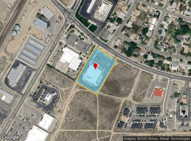
Property Record
880 Hanson St, Winnemucca, NV 89445
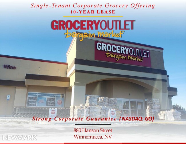
This Property Is For Sale
NEARBY LISTINGS FOR SALE OR LEASE
Property Detail
880 Hanson St
16-0251-37
Patrick Morrissey
Commercialnec
PARCEL A OF PM P/F PATRICK MORRISSEY WITHIN SW1/4 SEC: 29 TWN: 36N RNG: 38E ACRES: 2.05 MDB&M CITY OF WINNEMUCCA, NV RECORDED 3/19/2018 AS FILE#2018-1203 CREATED FROM SPLIT OF PARCEL # 16-0251-35 PRIMARY NEW PARCEL IS PARCEL # 16-0251-38
X
Humboldt
32013C4130C
Nevada
2025
2.05 AC
2025
Carson City/Nevada Area
010701
Other Market Areas
21,344 SF
Winnemucca, NV
DEMOGRAPHICS near 880 Hanson St
1 mile
3 mile
5 mile
2024 Total Population
5,161
10,002
12,909
2029 Population
5,174
9,994
12,926
Pop Growth 2024-2029
+ 0.25%
(0.08%)
+ 0.13%
Average Age
37
37
38
2024 Total Households
2,153
3,926
4,971
HH Growth 2024-2029
+ 0.37%
+ 0.03%
+ 0.20%
Median Household Inc
$64,131
$71,136
$73,033
Avg Household Size
2.40
2.50
2.60
2024 Avg HH Vehicles
2.00
2.00
2.00
Median Home Value
$241,959
$306,079
$292,532
Median Year Built
1982
1984
1986
Nearby Places
Map Layers
Map Styles
 Street
 Aerial
Transit
 Traffic
 Biking
Places
Listings with unknown addresses are not visible on the map
- Restaurants
- Banks
- Shops
- Fitness
- Groceries
PUBLIC TRANSPORTATION
COMMUTER RAIL
Winnemucca Amtrak (California Zephyr - Amtrak)
Drive
Walk
Distance
Winnemucca Amtrak (California Zephyr - Amtrak)
3 min
13 min
0.7 mi
Freight Ports
Port of Stockton
Drive
Walk
Distance
Port of Stockton
370 min
343.3 mi
Nearby Properties
Address
Land Use
TOTAL SIZE
Lot Size
Zoning
Address
Land Use
TOTAL SIZE
Lot Size
Zoning
202,337 SF
5.72 AC
P-F
Address
Land Use
TOTAL SIZE
Lot Size
Zoning
155,453 SF
40 AC
P-F
Address
Land Use
TOTAL SIZE
Lot Size
Zoning
68,112 SF
11.05 AC
P-F
Address
Land Use
TOTAL SIZE
Lot Size
Zoning
177,008 SF
15.74 AC
M-1
Address
Land Use
TOTAL SIZE
Lot Size
Zoning
75,000 SF
13.56 AC
P-F
Address
Land Use
TOTAL SIZE
Lot Size
Zoning
115,173 SF
10.35 AC
P-F
Address
Land Use
TOTAL SIZE
Lot Size
Zoning
26,044 SF
15.19 AC
G-C
Address
Land Use
TOTAL SIZE
Lot Size
Zoning
36,021 SF
4.21 AC
R-1-6
Address
Land Use
TOTAL SIZE
Lot Size
Zoning
28,204 SF
5 AC
P-F
Address
Land Use
TOTAL SIZE
Lot Size
Zoning
42,962 SF
1.94 AC
G-C
Address
Land Use
TOTAL SIZE
Lot Size
Zoning
32,831 SF
4.36 AC
P-F
Address
Land Use
TOTAL SIZE
Lot Size
Zoning
7,968 SF
5 AC
G-C
Address
Land Use
TOTAL SIZE
Lot Size
Zoning
64,635 SF
2.12 AC
R-3
Address
Land Use
TOTAL SIZE
Lot Size
Zoning
59,436 SF
10.34 AC
P-F
Address
Land Use
TOTAL SIZE
Lot Size
Zoning
7,400 SF
3.30 AC
MULT
Address
Land Use
TOTAL SIZE
Lot Size
Zoning
74,206 SF
3.27 AC
G-C
Address
Land Use
TOTAL SIZE
Lot Size
Zoning
46,657 SF
12.22 AC
G-C
Address
Land Use
TOTAL SIZE
Lot Size
Zoning
9,609 SF
8.29 AC
G-C
Address
Land Use
TOTAL SIZE
Lot Size
Zoning
43,889 SF
2.25 AC
G-C
Address
Land Use
TOTAL SIZE
Lot Size
Zoning
70,600 SF
8.40 AC
M-1
Address
Land Use
TOTAL SIZE
Lot Size
Zoning
49,874 SF
2.63 AC
P-F
Address
Land Use
TOTAL SIZE
Lot Size
Zoning
480 SF
21.70 AC
M-1
Address
Land Use
TOTAL SIZE
Lot Size
Zoning
65,366 SF
0.89 AC
G-C
Address
Land Use
TOTAL SIZE
Lot Size
Zoning
10,326 SF
3.40 AC
M-1
Address
Land Use
TOTAL SIZE
Lot Size
Zoning
6,592 SF
3 AC
R-3
Address
Land Use
TOTAL SIZE
Lot Size
Zoning
42,284 SF
1.74 AC
G-C
Address
Land Use
TOTAL SIZE
Lot Size
Zoning
34,541 SF
5.17 AC
M-1
Address
Land Use
TOTAL SIZE
Lot Size
Zoning
5,776 SF
4.53 AC
R-3
Address
Land Use
TOTAL SIZE
Lot Size
Zoning
6,248 SF
2.24 AC
G-C
Address
Land Use
TOTAL SIZE
Lot Size
Zoning
5,952 SF
4.37 AC
M-1
The World's #1 Commercial Real Estate Marketplace
Connect with us
© 2026 CoStar Group
The information above has been obtained from sources believed reliable. While we do not doubt its accuracy we have not verified it and make no guarantee, warranty or representation about it. It is your responsibility to independently confirm its accuracy and completeness. Any projections, opinions, assumptions, or estimates used are for example only and do not represent the current or future performance of the property. The value of this transaction to you depends on tax and other factors which should be evaluated by your tax, financial, and legal advisors. You and your advisors should conduct a careful, independent investigation of the property to determine to your satisfaction the suitability of the property for your needs.