Property Record
880 Verdulera St, Camarillo, CA 93010
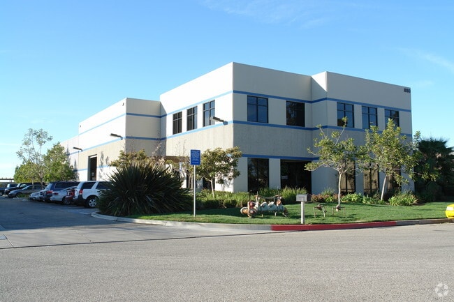


This Property Is For Sale
Property Detail
880 Verdulera St
230-0-131-085
TRACT: 208100 REF: 60 MR 48
Lightindustrial
Ventura
M2
California
C and X Area of minimal flood hazard, usually depicted on FIRMs as above the 500-year flood level.
1.06 AC
2024
Central Ventura
2025
Los Angeles
005602
Oxnard-Thousand Oaks-Ventura, CA
443 SF
NEARBY LISTINGS FOR SALE OR LEASE
DEMOGRAPHICS near 880 Verdulera St
1 mile
3 mile
5 mile
2025 Total Population
2,031
29,263
125,979
2030 Population
2,040
29,083
124,784
Pop Growth 2025-2030
+ 0.44%
(0.62%)
(0.95%)
Average Age
41
41
38
2025 Total Households
837
10,591
37,637
HH Growth 2025-2030
+ 0.24%
(0.69%)
(0.98%)
Median Household Inc
$124,540
$110,445
$107,424
Avg Household Size
2.40
2.70
3.20
2025 Avg HH Vehicles
2.00
2.00
2.00
Median Home Value
$847,457
$861,520
$750,920
Median Year Built
2006
1977
1980
Nearby Places
Map Layers
Map Styles
 Street
 Aerial
Layers
 Traffic
 Biking
Places
Listings with unknown addresses are not visible on the map
- Restaurants
- Banks
- Shops
- Fitness
- Groceries
PUBLIC TRANSPORTATION
COMMUTER RAIL
Camarillo (Ventura County Line - Southern California Regional Rail Authority (Metrolink))
Drive
Walk
Distance
Camarillo (Ventura County Line - Southern California Regional Rail Authority (Metrolink))
6 min
3.7 mi
Drive
Walk
Distance
12 min
7.6 mi
Freight Ports
The Port of Hueneme
Drive
Walk
Distance
The Port of Hueneme
20 min
11.1 mi
Nearby Properties
Address
Land Use
TOTAL SIZE
Lot Size
Zoning
Address
Land Use
TOTAL SIZE
Lot Size
Zoning
135,631 SF
74.32 AC
Address
Land Use
TOTAL SIZE
Lot Size
Zoning
25.09 AC
Address
Land Use
TOTAL SIZE
Lot Size
Zoning
159.70 AC
Address
Land Use
TOTAL SIZE
Lot Size
Zoning
31.75 AC
Address
Land Use
TOTAL SIZE
Lot Size
Zoning
19,288 SF
24.55 AC
CPD
Address
Land Use
TOTAL SIZE
Lot Size
Zoning
10.59 AC
Address
Land Use
TOTAL SIZE
Lot Size
Zoning
72,165 SF
24.05 AC
L-M
Address
Land Use
TOTAL SIZE
Lot Size
Zoning
33,261 SF
36.25 AC
Address
Land Use
TOTAL SIZE
Lot Size
Zoning
150,320 SF
6.22 AC
Address
Land Use
TOTAL SIZE
Lot Size
Zoning
123,752 SF
5.98 AC
RPD
Address
Land Use
TOTAL SIZE
Lot Size
Zoning
30,800 SF
32.79 AC
M-1-
Address
Land Use
TOTAL SIZE
Lot Size
Zoning
15.59 AC
Address
Land Use
TOTAL SIZE
Lot Size
Zoning
8,398 SF
45.88 AC
M1PD
Address
Land Use
TOTAL SIZE
Lot Size
Zoning
70,392 SF
19.97 AC
4
Address
Land Use
TOTAL SIZE
Lot Size
Zoning
39,607 SF
10.81 AC
LM
Address
Land Use
TOTAL SIZE
Lot Size
Zoning
84,518 SF
4.71 AC
RPD
Address
Land Use
TOTAL SIZE
Lot Size
Zoning
390 SF
39.49 AC
Address
Land Use
TOTAL SIZE
Lot Size
Zoning
88,224 SF
7.40 AC
Address
Land Use
TOTAL SIZE
Lot Size
Zoning
60,511 SF
2.95 AC
RPD30
Address
Land Use
TOTAL SIZE
Lot Size
Zoning
66,715 SF
4.07 AC
Address
Land Use
TOTAL SIZE
Lot Size
Zoning
3.08 AC
Address
Land Use
TOTAL SIZE
Lot Size
Zoning
44,806 SF
17.71 AC
Address
Land Use
TOTAL SIZE
Lot Size
Zoning
339.53 AC
Address
Land Use
TOTAL SIZE
Lot Size
Zoning
117,030 SF
17.35 AC
M1PD
Address
Land Use
TOTAL SIZE
Lot Size
Zoning
Address
Land Use
TOTAL SIZE
Lot Size
Zoning
66,315 SF
2.37 AC
CPD
Address
Land Use
TOTAL SIZE
Lot Size
Zoning
97,392 SF
5.35 AC
ML
Address
Land Use
TOTAL SIZE
Lot Size
Zoning
1,728 SF
7.11 AC
MIPD
Address
Land Use
TOTAL SIZE
Lot Size
Zoning
44,456 SF
11.64 AC
Address
Land Use
TOTAL SIZE
Lot Size
Zoning
82,754 SF
0.93 AC
PO
The World's #1 Commercial Real Estate Marketplace
Connect with us
© 2026 CoStar Group
The information above has been obtained from sources believed reliable. While we do not doubt its accuracy we have not verified it and make no guarantee, warranty or representation about it. It is your responsibility to independently confirm its accuracy and completeness. Any projections, opinions, assumptions, or estimates used are for example only and do not represent the current or future performance of the property. The value of this transaction to you depends on tax and other factors which should be evaluated by your tax, financial, and legal advisors. You and your advisors should conduct a careful, independent investigation of the property to determine to your satisfaction the suitability of the property for your needs.