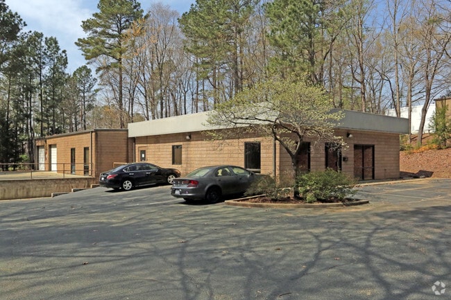
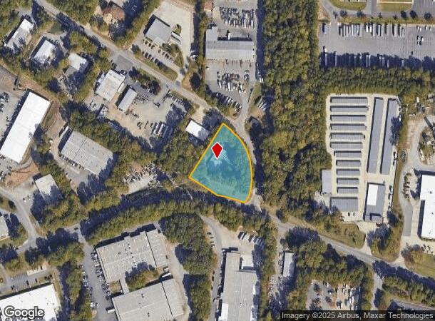
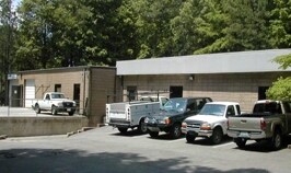
Property Record
8801 Midway West Rd, Raleigh, NC 27617
NEARBY LISTINGS FOR SALE OR LEASE
Property Detail
8801 Midway West Rd
Raleigh, NC
Leesville Indust Park Ph I
0778.03-24-5266-000
L21 LEESVILLE INDUSTRIAL P PHI BM1980-00
Officebuilding
Wake
X
North Carolina
3720077800K
21
2025
1.34 AC
2025
Glenwood/Creedmoor
053717
Raleigh/Durham
5,091 SF
DEMOGRAPHICS near 8801 Midway West Rd
1 Mile
3 Mile
5 Mile
2024 Total Population
1,854
47,579
110,247
2029 Population
1,984
51,249
118,611
Pop Growth 2024-2029
+ 7.01%
+ 7.71%
+ 7.59%
Average Age
35
40
40
2024 Total Households
582
20,834
49,471
HH Growth 2024-2029
+ 6.87%
+ 7.80%
+ 7.69%
Median Household Inc
$146,329
$112,155
$101,567
Avg Household Size
3.20
2.30
2.20
2024 Avg HH Vehicles
3.00
2.00
2.00
Median Home Value
$382,870
$408,572
$412,652
Median Year Built
1994
2003
1999
Nearby Places
Map Layers
Map Styles
 Street
 Aerial
- Restaurants
- Banks
- Shops
- Fitness
- Groceries
PUBLIC TRANSPORTATION
AIRPORT
Raleigh-Durham International
DRIVE
WALK
Distance
Raleigh-Durham International
7 min
3.2 mi
SALE & LEASE HISTORY
LISTING DATE
SALE/LEASE

Aug 09, 2023
For Lease
Nearby Properties
Address
Land Use
TOTAL SIZE
Lot Size
Zoning
Address
Land Use
TOTAL SIZE
Lot Size
Zoning
24,907 SF
5,245.45 AC
R-4
Address
Land Use
TOTAL SIZE
Lot Size
Zoning
600,334 SF
97.88 AC
R-4
Address
Land Use
TOTAL SIZE
Lot Size
Zoning
543,777 SF
28.13 AC
RX-4
Address
Land Use
TOTAL SIZE
Lot Size
Zoning
385,640 SF
36.45 AC
RX-4
Address
Land Use
TOTAL SIZE
Lot Size
Zoning
441,283 SF
23.76 AC
PD
Address
Land Use
TOTAL SIZE
Lot Size
Zoning
451,590 SF
36.02 AC
RX-5
Address
Land Use
TOTAL SIZE
Lot Size
Zoning
394,445 SF
34.80 AC
R-4
Address
Land Use
TOTAL SIZE
Lot Size
Zoning
431,534 SF
23.20 AC
RX-4
Address
Land Use
TOTAL SIZE
Lot Size
Zoning
370,540 SF
20.79 AC
PD
Address
Land Use
TOTAL SIZE
Lot Size
Zoning
287,656 SF
20.62 AC
PDR-H
Address
Land Use
TOTAL SIZE
Lot Size
Zoning
303,191 SF
19.18 AC
PD
Address
Land Use
TOTAL SIZE
Lot Size
Zoning
407,178 SF
22.57 AC
PD
Address
Land Use
TOTAL SIZE
Lot Size
Zoning
262,391 SF
8 AC
PD
Address
Land Use
TOTAL SIZE
Lot Size
Zoning
267,757 SF
35.89 AC
CX-5
Address
Land Use
TOTAL SIZE
Lot Size
Zoning
303,290 SF
14.48 AC
RX-3
Address
Land Use
TOTAL SIZE
Lot Size
Zoning
386,506 SF
55.21 AC
IH
Address
Land Use
TOTAL SIZE
Lot Size
Zoning
296,141 SF
14.38 AC
PD
Address
Land Use
TOTAL SIZE
Lot Size
Zoning
318,216 SF
6.36 AC
OX-7
Address
Land Use
TOTAL SIZE
Lot Size
Zoning
281,616 SF
18.69 AC
PD
Address
Land Use
TOTAL SIZE
Lot Size
Zoning
145,943 SF
34.96 AC
R-10
Address
Land Use
TOTAL SIZE
Lot Size
Zoning
197,578 SF
9.33 AC
CX-5
Address
Land Use
TOTAL SIZE
Lot Size
Zoning
216,039 SF
13.76 AC
RX-5
Address
Land Use
TOTAL SIZE
Lot Size
Zoning
239,661 SF
15.60 AC
RX-5
Address
Land Use
TOTAL SIZE
Lot Size
Zoning
194,040 SF
4.49 AC
PD
Address
Land Use
TOTAL SIZE
Lot Size
Zoning
253,157 SF
15.30 AC
RX-3
Address
Land Use
TOTAL SIZE
Lot Size
Zoning
201,831 SF
6.40 AC
PD
Address
Land Use
TOTAL SIZE
Lot Size
Zoning
245,158 SF
12.78 AC
RX-3
Address
Land Use
TOTAL SIZE
Lot Size
Zoning
303,212 SF
20.94 AC
RX-4
Address
Land Use
TOTAL SIZE
Lot Size
Zoning
151,786 SF
26.25 AC
R-4
Address
Land Use
TOTAL SIZE
Lot Size
Zoning
171,605 SF
6.70 AC
CX-3
The World's #1 Commercial Real Estate Marketplace
Connect with us
© 2025 CoStar Group
The information above has been obtained from sources believed reliable. While we do not doubt its accuracy we have not verified it and make no guarantee, warranty or representation about it. It is your responsibility to independently confirm its accuracy and completeness. Any projections, opinions, assumptions, or estimates used are for example only and do not represent the current or future performance of the property. The value of this transaction to you depends on tax and other factors which should be evaluated by your tax, financial, and legal advisors. You and your advisors should conduct a careful, independent investigation of the property to determine to your satisfaction the suitability of the property for your needs.