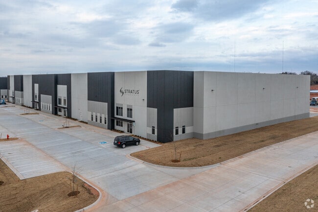
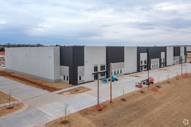
Property Record
8801 N I 35 Service Rd, Oklahoma City, OK 73131
NEARBY LISTINGS FOR SALE OR LEASE
Property Detail
8801 N I 35 Service Rd
134844005
Unplatted Pt Sec 31 13N 2W
Warehouse
HARTZELL TOWNSHIP PT SW4 SEC 31 13N 2W BEG 1184.62FT E OF SW/C NW4 TH NW211.83FT NELY1051.11FT SE565.76FT SWLY491.19FT SELY132.57FT SWLY70.11FT RIGHT ON CURVE SW395.18FT SW79.34FT W516.05FT TO BEG
X
Oklahoma
40109C0190H
Oklahoma
2023
16.14 AC
2024
Northeast
108110
Oklahoma City
160,816 SF
Oklahoma City, OK
DEMOGRAPHICS near 8801 N I 35 Service Rd
1 Mile
3 Mile
5 Mile
2024 Total Population
469
8,655
67,666
2029 Population
483
8,813
69,608
Pop Growth 2024-2029
+ 2.99%
+ 1.83%
+ 2.87%
Average Age
42
42
38
2024 Total Households
161
3,169
27,740
HH Growth 2024-2029
+ 3.11%
+ 1.86%
+ 3.04%
Median Household Inc
$114,583
$79,583
$55,127
Avg Household Size
2.70
2.60
2.30
2024 Avg HH Vehicles
3.00
2.00
2.00
Median Home Value
$478,571
$283,547
$217,537
Median Year Built
2000
1976
1975
Nearby Places
Map Layers
Map Styles
 Street
 Aerial
- Restaurants
- Banks
- Shops
- Fitness
- Groceries
PUBLIC TRANSPORTATION
AIRPORT
Will Rogers World
DRIVE
WALK
Distance
Will Rogers World
31 min
19.1 mi
Freight Ports
Tulsa Port Of Catoosa
DRIVE
WALK
Distance
Tulsa Port Of Catoosa
125 min
115.3 mi
Nearby Properties
Address
Land Use
TOTAL SIZE
Lot Size
Zoning
Address
Land Use
TOTAL SIZE
Lot Size
Zoning
93,244 SF
7.54 AC
PUD
Address
Land Use
TOTAL SIZE
Lot Size
Zoning
241,874 SF
36.89 AC
PUD
Address
Land Use
TOTAL SIZE
Lot Size
Zoning
280,970 SF
24.32 AC
Address
Land Use
TOTAL SIZE
Lot Size
Zoning
145,124 SF
55 AC
PUD
Address
Land Use
TOTAL SIZE
Lot Size
Zoning
39,800 SF
4.10 AC
PUD
Address
Land Use
TOTAL SIZE
Lot Size
Zoning
316,358 SF
39.39 AC
PUD
Address
Land Use
TOTAL SIZE
Lot Size
Zoning
70,284 SF
9.40 AC
PUD
Address
Land Use
TOTAL SIZE
Lot Size
Zoning
220,800 SF
14.55 AC
PUD
Address
Land Use
TOTAL SIZE
Lot Size
Zoning
58,293 SF
10.88 AC
C-4
Address
Land Use
TOTAL SIZE
Lot Size
Zoning
46,390 SF
14.13 AC
Address
Land Use
TOTAL SIZE
Lot Size
Zoning
214,478 SF
22 AC
PUD
Address
Land Use
TOTAL SIZE
Lot Size
Zoning
131,180 SF
12.90 AC
I-2
Address
Land Use
TOTAL SIZE
Lot Size
Zoning
110,172 SF
33.65 AC
PUD
Address
Land Use
TOTAL SIZE
Lot Size
Zoning
145,600 SF
16.38 AC
PUD
Address
Land Use
TOTAL SIZE
Lot Size
Zoning
92,712 SF
54.28 AC
PUD
Address
Land Use
TOTAL SIZE
Lot Size
Zoning
6,286 SF
1.03 AC
C-3
Address
Land Use
TOTAL SIZE
Lot Size
Zoning
4,041 SF
0.38 AC
PUD
Address
Land Use
TOTAL SIZE
Lot Size
Zoning
125,440 SF
10.92 AC
PUD
Address
Land Use
TOTAL SIZE
Lot Size
Zoning
48,768 SF
5.47 AC
PUD
Address
Land Use
TOTAL SIZE
Lot Size
Zoning
7,360 SF
4.69 AC
SPUD
Address
Land Use
TOTAL SIZE
Lot Size
Zoning
104,186 SF
21.32 AC
R-4
Address
Land Use
TOTAL SIZE
Lot Size
Zoning
4,479 SF
0.18 AC
PUD
Address
Land Use
TOTAL SIZE
Lot Size
Zoning
88,116 SF
38.22 AC
C-3
Address
Land Use
TOTAL SIZE
Lot Size
Zoning
147,511 SF
2.84 AC
Address
Land Use
TOTAL SIZE
Lot Size
Zoning
138,600 SF
9.30 AC
PUD
Address
Land Use
TOTAL SIZE
Lot Size
Zoning
99,577 SF
8.09 AC
PUD
Address
Land Use
TOTAL SIZE
Lot Size
Zoning
6,000 SF
2.24 AC
C-3
Address
Land Use
TOTAL SIZE
Lot Size
Zoning
45,414 SF
1.79 AC
SPUD
The World's #1 Commercial Real Estate Marketplace
Connect with us
© 2026 CoStar Group
The information above has been obtained from sources believed reliable. While we do not doubt its accuracy we have not verified it and make no guarantee, warranty or representation about it. It is your responsibility to independently confirm its accuracy and completeness. Any projections, opinions, assumptions, or estimates used are for example only and do not represent the current or future performance of the property. The value of this transaction to you depends on tax and other factors which should be evaluated by your tax, financial, and legal advisors. You and your advisors should conduct a careful, independent investigation of the property to determine to your satisfaction the suitability of the property for your needs.