Property Record
8801 Pyott Rd, Lake In The Hills, IL 60156

NEARBY LISTINGS FOR SALE OR LEASE
-
-
View all Lake In The Hills listings for sale on LoopNet.com
Property Detail
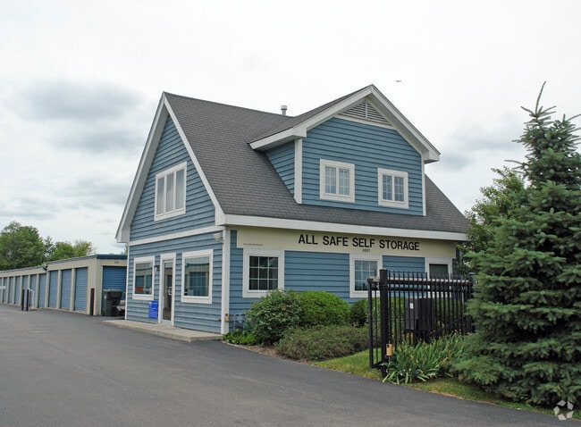
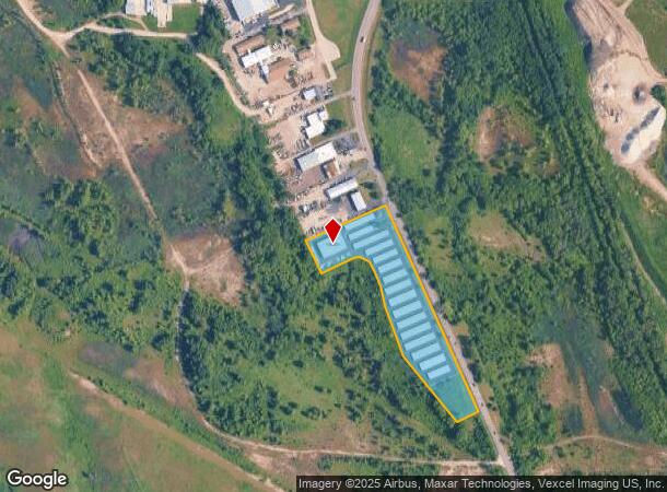
8801 Pyott Rd
19-16-300-023
DOC 2021R0065919 PC LYING SWLY PYOTT RD W1/2 SW1/4
Commercialnec
McHenry
X
Illinois
17111C0329J
7.62 AC
2024
Far Northwest
2024
Chicago
871209
Chicago-Naperville-Elgin, IL-IN-WI
109,607 SF
DEMOGRAPHICS near 8801 Pyott Rd
1 Mile
3 Mile
5 Mile
2024 Total Population
1,794
65,197
150,154
2029 Population
1,808
65,267
150,229
Pop Growth 2024-2029
+ 0.78%
+ 0.11%
+ 0.05%
Average Age
39
40
40
2024 Total Households
733
24,041
53,552
HH Growth 2024-2029
+ 0.82%
+ 0.12%
+ 0.07%
Median Household Inc
$63,552
$91,450
$102,110
Avg Household Size
2.30
2.70
2.80
2024 Avg HH Vehicles
2.00
2.00
2.00
Median Home Value
$146,444
$249,317
$267,576
Median Year Built
1981
1989
1991
Nearby Places
Map Layers
Map Styles
 Street
 Aerial
- Restaurants
- Banks
- Shops
- Fitness
- Groceries
PUBLIC TRANSPORTATION
COMMUTER RAIL
Crystal Lake Station (Union Pacific Northwest Line - Northeast Illinois Regional Commuter Railroad (Metra))
DRIVE
WALK
Distance
Crystal Lake Station (Union Pacific Northwest Line - Northeast Illinois Regional Commuter Railroad (Metra))
7 min
3.2 mi
Pingree Road Station (Union Pacific Northwest Line - Northeast Illinois Regional Commuter Railroad (Metra))
DRIVE
WALK
Distance
Pingree Road Station (Union Pacific Northwest Line - Northeast Illinois Regional Commuter Railroad (Metra))
9 min
3.5 mi
AIRPORT
Chicago O'Hare International
DRIVE
WALK
Distance
Chicago O'Hare International
47 min
32.6 mi
Freight Ports
Port Milwaukee
DRIVE
WALK
Distance
Port Milwaukee
103 min
77.3 mi
Nearby Properties
Address
Land Use
TOTAL SIZE
Lot Size
Zoning
Address
Land Use
TOTAL SIZE
Lot Size
Zoning
Address
Land Use
TOTAL SIZE
Lot Size
Zoning
Address
Land Use
TOTAL SIZE
Lot Size
Zoning
28.48 AC
Address
Land Use
TOTAL SIZE
Lot Size
Zoning
449,650 SF
25 AC
Address
Land Use
TOTAL SIZE
Lot Size
Zoning
15.94 AC
Address
Land Use
TOTAL SIZE
Lot Size
Zoning
147,496 SF
11.81 AC
Address
Land Use
TOTAL SIZE
Lot Size
Zoning
Address
Land Use
TOTAL SIZE
Lot Size
Zoning
11.91 AC
Address
Land Use
TOTAL SIZE
Lot Size
Zoning
Address
Land Use
TOTAL SIZE
Lot Size
Zoning
64,269 SF
5.08 AC
Address
Land Use
TOTAL SIZE
Lot Size
Zoning
28.69 AC
Address
Land Use
TOTAL SIZE
Lot Size
Zoning
20.81 AC
Address
Land Use
TOTAL SIZE
Lot Size
Zoning
Address
Land Use
TOTAL SIZE
Lot Size
Zoning
173,572 SF
17.03 AC
Address
Land Use
TOTAL SIZE
Lot Size
Zoning
71,703 SF
0.50 AC
Address
Land Use
TOTAL SIZE
Lot Size
Zoning
8.32 AC
Address
Land Use
TOTAL SIZE
Lot Size
Zoning
175,185 SF
13 AC
Address
Land Use
TOTAL SIZE
Lot Size
Zoning
Address
Land Use
TOTAL SIZE
Lot Size
Zoning
9,614 SF
1.42 AC
Address
Land Use
TOTAL SIZE
Lot Size
Zoning
106,309 SF
12.96 AC
Address
Land Use
TOTAL SIZE
Lot Size
Zoning
Address
Land Use
TOTAL SIZE
Lot Size
Zoning
125,187 SF
10.59 AC
Address
Land Use
TOTAL SIZE
Lot Size
Zoning
Address
Land Use
TOTAL SIZE
Lot Size
Zoning
66,594 SF
5.22 AC
Address
Land Use
TOTAL SIZE
Lot Size
Zoning
47,164 SF
0.70 AC
Address
Land Use
TOTAL SIZE
Lot Size
Zoning
134,523 SF
15.27 AC
Address
Land Use
TOTAL SIZE
Lot Size
Zoning
51,909 SF
0.50 AC
Address
Land Use
TOTAL SIZE
Lot Size
Zoning
34,448 SF
2 AC
Address
Land Use
TOTAL SIZE
Lot Size
Zoning
The World's #1 Commercial Real Estate Marketplace
Connect with us
© 2026 CoStar Group
The information above has been obtained from sources believed reliable. While we do not doubt its accuracy we have not verified it and make no guarantee, warranty or representation about it. It is your responsibility to independently confirm its accuracy and completeness. Any projections, opinions, assumptions, or estimates used are for example only and do not represent the current or future performance of the property. The value of this transaction to you depends on tax and other factors which should be evaluated by your tax, financial, and legal advisors. You and your advisors should conduct a careful, independent investigation of the property to determine to your satisfaction the suitability of the property for your needs.