Property Record
8801 Staples Mill Rd, Henrico, VA 23228

Current Lease Availabilities
NEARBY LISTINGS FOR SALE OR LEASE
Property Detail
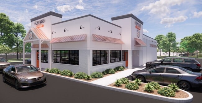
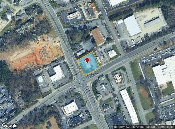
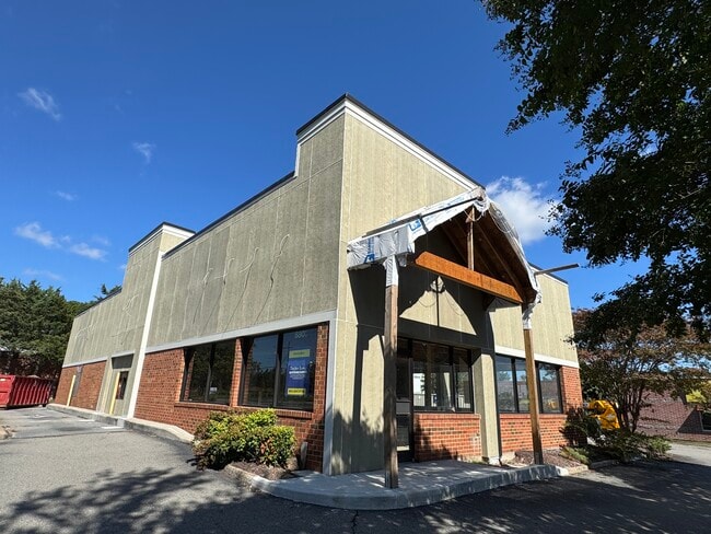
8801 Staples Mill Rd
770-755-1657
C&N Dining Ii
Restaurantdrivein
00610A0000 0060; STAPLES MLL & PARHM AC .832 92 B2 144
X
Henrico
51085C0295C
Virginia
2025
0.83 AC
2025
Staples Mill/Parham
200503
Richmond VA
3,564 SF
Richmond, VA
DEMOGRAPHICS near 8801 Staples Mill Rd
1 Mile
3 Mile
5 Mile
2024 Total Population
9,931
85,771
198,883
2029 Population
9,899
85,531
199,629
Pop Growth 2024-2029
(0.32%)
(0.28%)
+ 0.38%
Average Age
37
39
40
2024 Total Households
4,063
36,233
83,684
HH Growth 2024-2029
(0.37%)
(0.25%)
+ 0.48%
Median Household Inc
$57,409
$70,455
$78,590
Avg Household Size
2.30
2.30
2.30
2024 Avg HH Vehicles
2.00
2.00
2.00
Median Home Value
$231,572
$266,491
$316,290
Median Year Built
1980
1978
1976
Nearby Places
- Restaurants
- Banks
- Shops
- Fitness
- Groceries
PUBLIC TRANSPORTATION
COMMUTER RAIL
DRIVE
WALK
Distance
4 min
1.5 mi
DRIVE
WALK
Distance
15 min
9.4 mi
AIRPORT
Richmond International
DRIVE
WALK
Distance
Richmond International
28 min
17.3 mi
Nearby Properties
Address
Land Use
TOTAL SIZE
Lot Size
Zoning
Address
Land Use
TOTAL SIZE
Lot Size
Zoning
172,000 SF
48.58 AC
R-3
Address
Land Use
TOTAL SIZE
Lot Size
Zoning
43,929 SF
46.83 AC
O-S
Address
Land Use
TOTAL SIZE
Lot Size
Zoning
585,792 SF
38.94 AC
R-5
Address
Land Use
TOTAL SIZE
Lot Size
Zoning
597,042 SF
41.03 AC
R-6C
Address
Land Use
TOTAL SIZE
Lot Size
Zoning
382,570 SF
2.98 AC
UMUC
Address
Land Use
TOTAL SIZE
Lot Size
Zoning
568,334 SF
26.13 AC
MIXE
Address
Land Use
TOTAL SIZE
Lot Size
Zoning
173,400 SF
42 AC
MIXE
Address
Land Use
TOTAL SIZE
Lot Size
Zoning
527,410 SF
40.70 AC
A-1
Address
Land Use
TOTAL SIZE
Lot Size
Zoning
104,972 SF
108.49 AC
MIXE
Address
Land Use
TOTAL SIZE
Lot Size
Zoning
266,138 SF
96.10 AC
R-2C
Address
Land Use
TOTAL SIZE
Lot Size
Zoning
309,500 SF
29.78 AC
MIXE
Address
Land Use
TOTAL SIZE
Lot Size
Zoning
344,965 SF
28.33 AC
MIXE
Address
Land Use
TOTAL SIZE
Lot Size
Zoning
271,060 SF
18.31 AC
R-6
Address
Land Use
TOTAL SIZE
Lot Size
Zoning
250,146 SF
20.41 AC
R-5
Address
Land Use
TOTAL SIZE
Lot Size
Zoning
1,404 SF
30.52 AC
R-5
Address
Land Use
TOTAL SIZE
Lot Size
Zoning
224,768 SF
18.08 AC
R-6
Address
Land Use
TOTAL SIZE
Lot Size
Zoning
296,784 SF
23.11 AC
R-5
Address
Land Use
TOTAL SIZE
Lot Size
Zoning
257,130 SF
33.65 AC
B-3
Address
Land Use
TOTAL SIZE
Lot Size
Zoning
7.98 AC
UMUC
Address
Land Use
TOTAL SIZE
Lot Size
Zoning
500,400 SF
31.15 AC
R-5
Address
Land Use
TOTAL SIZE
Lot Size
Zoning
232,368 SF
26.11 AC
R-5
Address
Land Use
TOTAL SIZE
Lot Size
Zoning
227,905 SF
58.94 AC
R-3
Address
Land Use
TOTAL SIZE
Lot Size
Zoning
180,070 SF
17.13 AC
R-5
Address
Land Use
TOTAL SIZE
Lot Size
Zoning
329,044 SF
8.09 AC
UMUC
Address
Land Use
TOTAL SIZE
Lot Size
Zoning
158,900 SF
18.52 AC
R-5
Address
Land Use
TOTAL SIZE
Lot Size
Zoning
167,576 SF
14.29 AC
R-5
Address
Land Use
TOTAL SIZE
Lot Size
Zoning
213,344 SF
16.28 AC
R-5
Address
Land Use
TOTAL SIZE
Lot Size
Zoning
158,568 SF
13.36 AC
R-5C
Address
Land Use
TOTAL SIZE
Lot Size
Zoning
24,165 SF
72.13 AC
C-1
Address
Land Use
TOTAL SIZE
Lot Size
Zoning
176,936 SF
6 AC
B-2C
The World's #1 Commercial Real Estate Marketplace
Connect with us
© 2025 CoStar Group
The information above has been obtained from sources believed reliable. While we do not doubt its accuracy we have not verified it and make no guarantee, warranty or representation about it. It is your responsibility to independently confirm its accuracy and completeness. Any projections, opinions, assumptions, or estimates used are for example only and do not represent the current or future performance of the property. The value of this transaction to you depends on tax and other factors which should be evaluated by your tax, financial, and legal advisors. You and your advisors should conduct a careful, independent investigation of the property to determine to your satisfaction the suitability of the property for your needs.