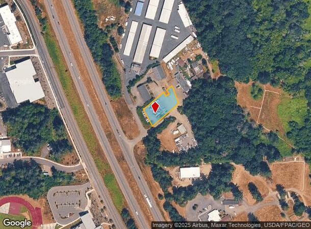
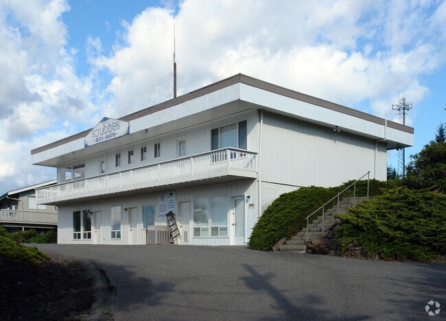
Property Record
8803 State Route 16 W, Gig Harbor, WA 98332

NEARBY LISTINGS FOR SALE OR LEASE
Property Detail
8803 State Route 16 W
022106-2054
SECTION 06 TOWNSHIP 21 RANGE 02 QUARTER 24 : COM CENT OF SEC TH ALG E & W C/L OF SEC S 88 DEG 41 MIN 18 SEC W 788.31 FT TO POB TH S 51 DEG 31 MIN 41 SEC W 170.98 FT TO PT ON ELY LI OF 60 FT STRIP OF LD REC UNDER FEE # 2028232 TH ALG SD ELY LI NWLY 10
Officebuilding
Pierce
X
Washington
53033C1200G
d
2024
0.43 AC
2025
Gig Harbor/W Pierce Co
072507
Seattle/Puget Sound
3,900 SF
Seattle-Tacoma-Bellevue, WA
DEMOGRAPHICS near 8803 State Route 16 W
1 Mile
3 Mile
5 Mile
2024 Total Population
3,493
30,239
55,815
2029 Population
3,654
31,396
57,608
Pop Growth 2024-2029
+ 4.61%
+ 3.83%
+ 3.21%
Average Age
48
45
45
2024 Total Households
1,506
11,803
21,667
HH Growth 2024-2029
+ 4.52%
+ 3.88%
+ 3.24%
Median Household Inc
$119,117
$124,208
$121,954
Avg Household Size
2.20
2.50
2.50
2024 Avg HH Vehicles
2.00
2.00
2.00
Median Home Value
$739,813
$727,772
$716,148
Median Year Built
1992
1992
1990
Nearby Places
Map Layers
Map Styles
 Street
 Aerial
- Restaurants
- Banks
- Shops
- Fitness
- Groceries
PUBLIC TRANSPORTATION
AIRPORT
Seattle-Tacoma International
DRIVE
WALK
Distance
Seattle-Tacoma International
55 min
36.9 mi
Freight Ports
Port of Tacoma
DRIVE
WALK
Distance
Port of Tacoma
28 min
18.5 mi
Nearby Properties
Address
Land Use
TOTAL SIZE
Lot Size
Zoning
Address
Land Use
TOTAL SIZE
Lot Size
Zoning
308,000 SF
23.44 AC
PCD-BP
Address
Land Use
TOTAL SIZE
Lot Size
Zoning
427,880 SF
17.97 AC
GIGH
Address
Land Use
TOTAL SIZE
Lot Size
Zoning
189,797 SF
18.06 AC
RB-2
Address
Land Use
TOTAL SIZE
Lot Size
Zoning
318,450 SF
36.63 AC
ED
Address
Land Use
TOTAL SIZE
Lot Size
Zoning
184,782 SF
23.38 AC
B-2
Address
Land Use
TOTAL SIZE
Lot Size
Zoning
192,969 SF
11.52 AC
PRD
Address
Land Use
TOTAL SIZE
Lot Size
Zoning
321,717 SF
75.30 AC
PI
Address
Land Use
TOTAL SIZE
Lot Size
Zoning
297,754 SF
59.70 AC
PI
Address
Land Use
TOTAL SIZE
Lot Size
Zoning
166,830 SF
7.36 AC
Address
Land Use
TOTAL SIZE
Lot Size
Zoning
91,277 SF
5.08 AC
GIGH
Address
Land Use
TOTAL SIZE
Lot Size
Zoning
115,222 SF
27.53 AC
Address
Land Use
TOTAL SIZE
Lot Size
Zoning
123,138 SF
14.89 AC
RB-2
Address
Land Use
TOTAL SIZE
Lot Size
Zoning
106,293 SF
7.60 AC
Address
Land Use
TOTAL SIZE
Lot Size
Zoning
87,475 SF
11 AC
Address
Land Use
TOTAL SIZE
Lot Size
Zoning
71,494 SF
14.14 AC
Address
Land Use
TOTAL SIZE
Lot Size
Zoning
117,424 SF
24.84 AC
R-1
Address
Land Use
TOTAL SIZE
Lot Size
Zoning
129,455 SF
9.44 AC
RB-2
Address
Land Use
TOTAL SIZE
Lot Size
Zoning
151,391 SF
17.49 AC
PCD-C
Address
Land Use
TOTAL SIZE
Lot Size
Zoning
110,156 SF
9.54 AC
B-2
Address
Land Use
TOTAL SIZE
Lot Size
Zoning
92,797 SF
0.69 AC
PCD-BP
Address
Land Use
TOTAL SIZE
Lot Size
Zoning
104,043 SF
1.92 AC
B-2
Address
Land Use
TOTAL SIZE
Lot Size
Zoning
114,306 SF
6.54 AC
R-3
Address
Land Use
TOTAL SIZE
Lot Size
Zoning
83,169 SF
6.66 AC
B-2
Address
Land Use
TOTAL SIZE
Lot Size
Zoning
62,960 SF
5.41 AC
C-1
Address
Land Use
TOTAL SIZE
Lot Size
Zoning
122,520 SF
10.76 AC
PCD-C
Address
Land Use
TOTAL SIZE
Lot Size
Zoning
77,906 SF
5 AC
R-1
Address
Land Use
TOTAL SIZE
Lot Size
Zoning
78,124 SF
4.65 AC
R-3
Address
Land Use
TOTAL SIZE
Lot Size
Zoning
105,563 SF
5.09 AC
B-2
Address
Land Use
TOTAL SIZE
Lot Size
Zoning
122,080 SF
16 AC
PCD-C
Address
Land Use
TOTAL SIZE
Lot Size
Zoning
63,700 SF
4.73 AC
B-2
The World's #1 Commercial Real Estate Marketplace
Connect with us
© 2025 CoStar Group
The information above has been obtained from sources believed reliable. While we do not doubt its accuracy we have not verified it and make no guarantee, warranty or representation about it. It is your responsibility to independently confirm its accuracy and completeness. Any projections, opinions, assumptions, or estimates used are for example only and do not represent the current or future performance of the property. The value of this transaction to you depends on tax and other factors which should be evaluated by your tax, financial, and legal advisors. You and your advisors should conduct a careful, independent investigation of the property to determine to your satisfaction the suitability of the property for your needs.