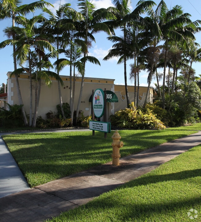
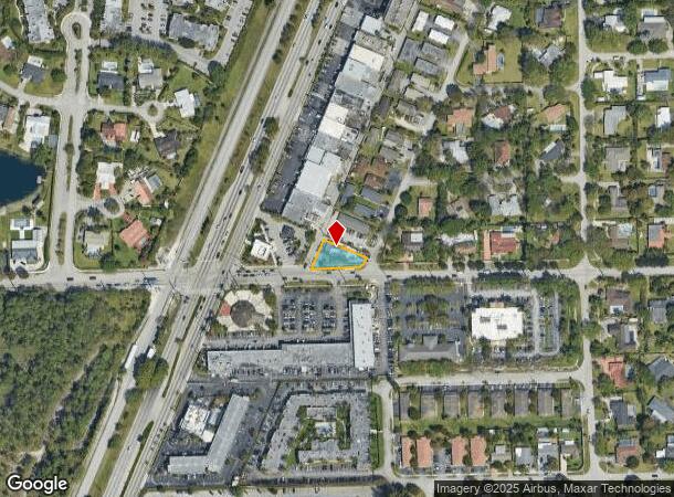
Property Record
8805 Sw 144Th St, Palmetto Bay, FL 33176

NEARBY LISTINGS FOR SALE OR LEASE
Property Detail
8805 Sw 144Th St
Miami-Miami Beach-Kendall, FL
Mitchell Center
33-5021-002-0160
21 55 40 MITCHELL CENTER PB 55-43 LOT 20 BLK 1 LOT SIZE 10187 SQUARE FEET OR 11502-974 0782 4 F/A/U 30-5021-002-0160 COC 25397-1895 01 2007 4
Officebuilding
Miami/Dade
X
Florida
12086C0464L
20
2024
0.23 AC
2025
Kendall
008206
South Florida
2,525 SF
DEMOGRAPHICS near 8805 Sw 144Th St
1 Mile
3 Mile
5 Mile
2024 Total Population
10,392
87,611
260,551
2029 Population
10,118
85,136
253,820
Pop Growth 2024-2029
(2.64%)
(2.82%)
(2.58%)
Average Age
42
42
42
2024 Total Households
4,047
28,568
92,226
HH Growth 2024-2029
(2.94%)
(3.24%)
(2.91%)
Median Household Inc
$92,431
$101,659
$75,942
Avg Household Size
2.50
2.90
2.70
2024 Avg HH Vehicles
2.00
2.00
2.00
Median Home Value
$648,277
$571,864
$432,119
Median Year Built
1975
1973
1978
Nearby Places
Map Layers
Map Styles
 Street
 Aerial
- Restaurants
- Banks
- Shops
- Fitness
- Groceries
PUBLIC TRANSPORTATION
COMMUTER RAIL
Dadeland South (Metrorail Green Line - Miami-Dade Transit (Metrorail/Metromover))
DRIVE
WALK
Distance
Dadeland South (Metrorail Green Line - Miami-Dade Transit (Metrorail/Metromover))
7 min
3.8 mi
Dadeland North (Metrorail Green Line - Miami-Dade Transit (Metrorail/Metromover))
DRIVE
WALK
Distance
Dadeland North (Metrorail Green Line - Miami-Dade Transit (Metrorail/Metromover))
9 min
4.7 mi
AIRPORT
Miami International
DRIVE
WALK
Distance
Miami International
25 min
13.9 mi
Fort Lauderdale/Hollywood International
DRIVE
WALK
Distance
Fort Lauderdale/Hollywood International
56 min
36.7 mi
Freight Ports
Port of Miami
DRIVE
WALK
Distance
Port of Miami
31 min
16.3 mi
Nearby Properties
Address
Land Use
TOTAL SIZE
Lot Size
Zoning
Address
Land Use
TOTAL SIZE
Lot Size
Zoning
846,804 SF
43 AC
6400
Address
Land Use
TOTAL SIZE
Lot Size
Zoning
340,763 SF
59.02 AC
0100
Address
Land Use
TOTAL SIZE
Lot Size
Zoning
504,698 SF
3.49 AC
6100
Address
Land Use
TOTAL SIZE
Lot Size
Zoning
425,003 SF
3.56 AC
4300
Address
Land Use
TOTAL SIZE
Lot Size
Zoning
199,915 SF
15.19 AC
6200
Address
Land Use
TOTAL SIZE
Lot Size
Zoning
426,436 SF
2.03 AC
6174
Address
Land Use
TOTAL SIZE
Lot Size
Zoning
250,133 SF
27.27 AC
6200
Address
Land Use
TOTAL SIZE
Lot Size
Zoning
360,424 SF
18.51 AC
2300
Address
Land Use
TOTAL SIZE
Lot Size
Zoning
318,925 SF
1.99 AC
6800
Address
Land Use
TOTAL SIZE
Lot Size
Zoning
350,683 SF
10.14 AC
6200
Address
Land Use
TOTAL SIZE
Lot Size
Zoning
313,755 SF
5 AC
2300
Address
Land Use
TOTAL SIZE
Lot Size
Zoning
251,016 SF
18.23 AC
6200
Address
Land Use
TOTAL SIZE
Lot Size
Zoning
235,115 SF
18.39 AC
2300
Address
Land Use
TOTAL SIZE
Lot Size
Zoning
237,857 SF
9.09 AC
2300
Address
Land Use
TOTAL SIZE
Lot Size
Zoning
197,772 SF
6.54 AC
6400
Address
Land Use
TOTAL SIZE
Lot Size
Zoning
187,775 SF
4.77 AC
9400
Address
Land Use
TOTAL SIZE
Lot Size
Zoning
96,075 SF
5.24 AC
6200
Address
Land Use
TOTAL SIZE
Lot Size
Zoning
574,534 SF
25.01 AC
4500
Address
Land Use
TOTAL SIZE
Lot Size
Zoning
77,861 SF
4.63 AC
6400
Address
Land Use
TOTAL SIZE
Lot Size
Zoning
141,192 SF
9.01 AC
6400
Address
Land Use
TOTAL SIZE
Lot Size
Zoning
72,334 SF
14.28 AC
4100
Address
Land Use
TOTAL SIZE
Lot Size
Zoning
176,865 SF
0.99 AC
7100
Address
Land Use
TOTAL SIZE
Lot Size
Zoning
134,794 SF
1.73 AC
6061
Address
Land Use
TOTAL SIZE
Lot Size
Zoning
147,505 SF
20 AC
2100
Address
Land Use
TOTAL SIZE
Lot Size
Zoning
163,619 SF
1.87 AC
7061
Address
Land Use
TOTAL SIZE
Lot Size
Zoning
148,982 SF
23.63 AC
0100
Address
Land Use
TOTAL SIZE
Lot Size
Zoning
129,920 SF
2.10 AC
7100
Address
Land Use
TOTAL SIZE
Lot Size
Zoning
174,130 SF
7.71 AC
6400
Address
Land Use
TOTAL SIZE
Lot Size
Zoning
46,955 SF
3.06 AC
6200
Address
Land Use
TOTAL SIZE
Lot Size
Zoning
117,006 SF
0.73 AC
7100
The World's #1 Commercial Real Estate Marketplace
Connect with us
© 2025 CoStar Group
The information above has been obtained from sources believed reliable. While we do not doubt its accuracy we have not verified it and make no guarantee, warranty or representation about it. It is your responsibility to independently confirm its accuracy and completeness. Any projections, opinions, assumptions, or estimates used are for example only and do not represent the current or future performance of the property. The value of this transaction to you depends on tax and other factors which should be evaluated by your tax, financial, and legal advisors. You and your advisors should conduct a careful, independent investigation of the property to determine to your satisfaction the suitability of the property for your needs.