Property Record
8807 Thornton Rd, Stockton, CA 95209

Current Lease Availabilities
NEARBY LISTINGS FOR SALE OR LEASE
Property Detail
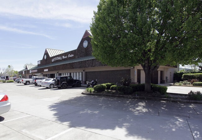
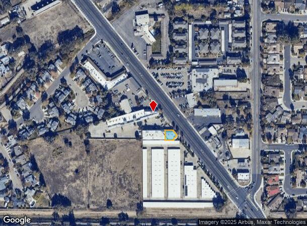
8807 Thornton Rd
080-450-25
Thornton Village Condo
Storebuilding
THORNTON VILLAGE MAP C2 40
X
San Joaquin
06077C0315F
California
2025
1.82 AC
2025
Stockton
003210
Stockton/Modesto
3,960 SF
Stockton-Lodi, CA
DEMOGRAPHICS near 8807 Thornton Rd
1 mile
3 mile
5 mile
2024 Total Population
23,281
143,272
254,442
2029 Population
24,585
151,021
268,549
Pop Growth 2024-2029
+ 5.60%
+ 5.41%
+ 5.54%
Average Age
38
37
37
2024 Total Households
7,267
46,939
82,438
HH Growth 2024-2029
+ 5.66%
+ 5.46%
+ 5.59%
Median Household Inc
$86,784
$75,199
$76,074
Avg Household Size
3.10
3.00
3.00
2024 Avg HH Vehicles
2.00
2.00
2.00
Median Home Value
$382,133
$393,031
$399,335
Median Year Built
1973
1979
1979
Nearby Places
Map Layers
Map Styles
 Street
 Aerial
Transit
 Traffic
 Biking
Places
Listings with unknown addresses are not visible on the map
- Restaurants
- Banks
- Shops
- Fitness
- Groceries
PUBLIC TRANSPORTATION
COMMUTER RAIL
Stockton (San Joaquins - Amtrak)
Drive
Walk
Distance
Stockton (San Joaquins - Amtrak)
15 min
6.8 mi
Stockton- Robert J Cabral Station (ACE Train - Altamont Corridor Express)
Drive
Walk
Distance
Stockton- Robert J Cabral Station (ACE Train - Altamont Corridor Express)
13 min
7.4 mi
AIRPORT
Stockton Metro
Drive
Walk
Distance
Stockton Metro
22 min
12.0 mi
Freight Ports
Port of Stockton
Drive
Walk
Distance
Port of Stockton
12 min
7.8 mi
Nearby Properties
Address
Land Use
TOTAL SIZE
Lot Size
Zoning
Address
Land Use
TOTAL SIZE
Lot Size
Zoning
105,083 SF
24.90 AC
O
Address
Land Use
TOTAL SIZE
Lot Size
Zoning
10,334 SF
22.41 AC
Address
Land Use
TOTAL SIZE
Lot Size
Zoning
60,137 SF
7.22 AC
Address
Land Use
TOTAL SIZE
Lot Size
Zoning
9,192 SF
6.63 AC
Address
Land Use
TOTAL SIZE
Lot Size
Zoning
324,208 SF
16.45 AC
Address
Land Use
TOTAL SIZE
Lot Size
Zoning
254,378 SF
17.07 AC
Address
Land Use
TOTAL SIZE
Lot Size
Zoning
27,000 SF
17.43 AC
Address
Land Use
TOTAL SIZE
Lot Size
Zoning
236,618 SF
22.37 AC
Address
Land Use
TOTAL SIZE
Lot Size
Zoning
161,229 SF
10.16 AC
Address
Land Use
TOTAL SIZE
Lot Size
Zoning
151,271 SF
8.97 AC
Address
Land Use
TOTAL SIZE
Lot Size
Zoning
14,212 SF
26.11 AC
Address
Land Use
TOTAL SIZE
Lot Size
Zoning
18.66 AC
Address
Land Use
TOTAL SIZE
Lot Size
Zoning
97,276 SF
5.46 AC
RHD
Address
Land Use
TOTAL SIZE
Lot Size
Zoning
89,725 SF
4.02 AC
Address
Land Use
TOTAL SIZE
Lot Size
Zoning
Address
Land Use
TOTAL SIZE
Lot Size
Zoning
123,800 SF
10.73 AC
Address
Land Use
TOTAL SIZE
Lot Size
Zoning
2.62 AC
Address
Land Use
TOTAL SIZE
Lot Size
Zoning
51,892 SF
5.33 AC
Address
Land Use
TOTAL SIZE
Lot Size
Zoning
76,700 SF
3.81 AC
Address
Land Use
TOTAL SIZE
Lot Size
Zoning
52,644 SF
2 AC
Address
Land Use
TOTAL SIZE
Lot Size
Zoning
14,035 SF
10.02 AC
Address
Land Use
TOTAL SIZE
Lot Size
Zoning
28,168 SF
6.61 AC
MX
Address
Land Use
TOTAL SIZE
Lot Size
Zoning
117,320 SF
2.86 AC
Address
Land Use
TOTAL SIZE
Lot Size
Zoning
81,482 SF
5 AC
RM
Address
Land Use
TOTAL SIZE
Lot Size
Zoning
67,195 SF
5.30 AC
Address
Land Use
TOTAL SIZE
Lot Size
Zoning
5,888 SF
3.64 AC
Address
Land Use
TOTAL SIZE
Lot Size
Zoning
119,341 SF
7.98 AC
Address
Land Use
TOTAL SIZE
Lot Size
Zoning
138,136 SF
13.60 AC
Address
Land Use
TOTAL SIZE
Lot Size
Zoning
176,492 SF
10.55 AC
The World's #1 Commercial Real Estate Marketplace
Connect with us
© 2026 CoStar Group
The information above has been obtained from sources believed reliable. While we do not doubt its accuracy we have not verified it and make no guarantee, warranty or representation about it. It is your responsibility to independently confirm its accuracy and completeness. Any projections, opinions, assumptions, or estimates used are for example only and do not represent the current or future performance of the property. The value of this transaction to you depends on tax and other factors which should be evaluated by your tax, financial, and legal advisors. You and your advisors should conduct a careful, independent investigation of the property to determine to your satisfaction the suitability of the property for your needs.