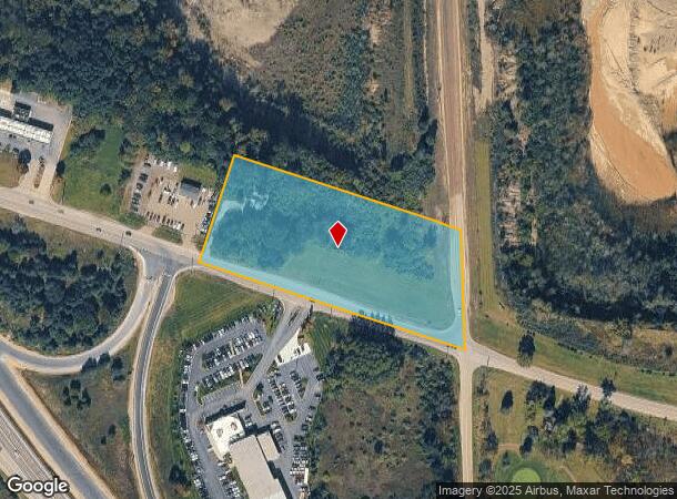
Property Record
8815 E Holly Rd, Holly, MI 48442
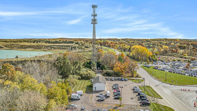
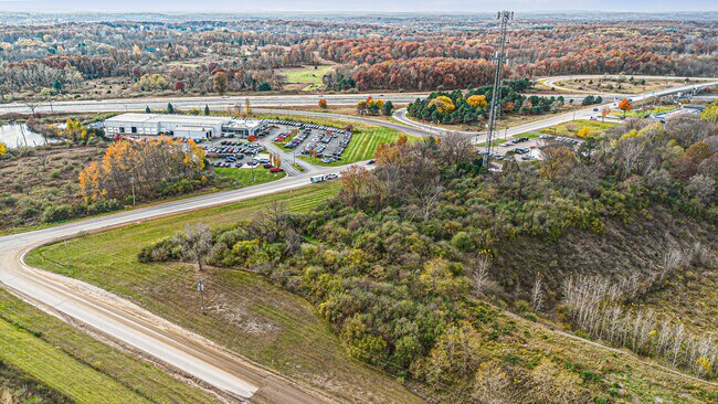
This Property Is For Sale
NEARBY LISTINGS FOR SALE OR LEASE
Property Detail
8815 E Holly Rd
07-05-226-007
T4N, R8E, SEC 5 PART OF NE 1/4 BEG AT PT DIST N 02-01-35 W 294.12 FT FROM E 1/4 COR, TH N 71-41-35 W 725 FT, TH N 18-18-25 E 293.01 FT, TH S 71-41-35 E 616.42 FT, TH S 02-01-35 E 312.47 FT TO BEG 4.51 A 6/22/89 FR 004
Commercialnec
Oakland
X
Michigan
26049C0475D
4.51 AC
2024
St Clair & Lapeer Counties
2024
Detroit
124000
Detroit-Warren-Dearborn, MI
DEMOGRAPHICS near 8815 E Holly Rd
1 Mile
3 Mile
5 Mile
2024 Total Population
1,329
8,190
25,141
2029 Population
1,354
8,187
25,091
Pop Growth 2024-2029
+ 1.88%
(0.04%)
(0.20%)
Average Age
39
42
43
2024 Total Households
517
3,093
9,479
HH Growth 2024-2029
+ 1.93%
(0.03%)
(0.18%)
Median Household Inc
$74,898
$95,214
$92,299
Avg Household Size
2.50
2.60
2.60
2024 Avg HH Vehicles
2.00
2.00
2.00
Median Home Value
$269,276
$322,059
$312,147
Median Year Built
1992
1989
1987
Nearby Places
- Restaurants
- Banks
- Shops
- Fitness
- Groceries
PUBLIC TRANSPORTATION
AIRPORT
Bishop International
DRIVE
WALK
Distance
Bishop International
33 min
20.3 mi
Freight Ports
Port of Toledo
DRIVE
WALK
Distance
Port of Toledo
118 min
92.5 mi
Nearby Properties
Address
Land Use
TOTAL SIZE
Lot Size
Zoning
Address
Land Use
TOTAL SIZE
Lot Size
Zoning
6,981 SF
88.04 AC
Address
Land Use
TOTAL SIZE
Lot Size
Zoning
8,617 SF
71.35 AC
MM
Address
Land Use
TOTAL SIZE
Lot Size
Zoning
59,491 SF
6.94 AC
C2GEN
Address
Land Use
TOTAL SIZE
Lot Size
Zoning
26,331 SF
6 AC
C2GEN
Address
Land Use
TOTAL SIZE
Lot Size
Zoning
57,600 SF
15.72 AC
M1LITE
Address
Land Use
TOTAL SIZE
Lot Size
Zoning
77,403 SF
4.58 AC
M1LITE
Address
Land Use
TOTAL SIZE
Lot Size
Zoning
14,218 SF
16.94 AC
Address
Land Use
TOTAL SIZE
Lot Size
Zoning
64,195 SF
5.01 AC
M1LITE
Address
Land Use
TOTAL SIZE
Lot Size
Zoning
24.97 AC
Address
Land Use
TOTAL SIZE
Lot Size
Zoning
11,526 SF
6.45 AC
BI
Address
Land Use
TOTAL SIZE
Lot Size
Zoning
31,378 SF
2.42 AC
M1LITE
Address
Land Use
TOTAL SIZE
Lot Size
Zoning
18,791 SF
30 AC
OSOFF
Address
Land Use
TOTAL SIZE
Lot Size
Zoning
26,701 SF
2.78 AC
M1LITE
Address
Land Use
TOTAL SIZE
Lot Size
Zoning
4,288 SF
126.64 AC
IV
Address
Land Use
TOTAL SIZE
Lot Size
Zoning
5,284 SF
4.64 AC
Address
Land Use
TOTAL SIZE
Lot Size
Zoning
68.92 AC
FI
Address
Land Use
TOTAL SIZE
Lot Size
Zoning
19,080 SF
40.01 AC
M1LITE
Address
Land Use
TOTAL SIZE
Lot Size
Zoning
4,428 SF
1.66 AC
PUD
Address
Land Use
TOTAL SIZE
Lot Size
Zoning
35,810 SF
2.01 AC
M1
Address
Land Use
TOTAL SIZE
Lot Size
Zoning
5,570 SF
3.56 AC
BI
Address
Land Use
TOTAL SIZE
Lot Size
Zoning
15,475 SF
3.50 AC
M1LITE
Address
Land Use
TOTAL SIZE
Lot Size
Zoning
11,653 SF
21.77 AC
BI
Address
Land Use
TOTAL SIZE
Lot Size
Zoning
8,827 SF
2.05 AC
C1 (*
Address
Land Use
TOTAL SIZE
Lot Size
Zoning
4,505 SF
3.30 AC
BI
Address
Land Use
TOTAL SIZE
Lot Size
Zoning
3,996 SF
1.74 AC
C2GEN
Address
Land Use
TOTAL SIZE
Lot Size
Zoning
66.44 AC
Address
Land Use
TOTAL SIZE
Lot Size
Zoning
32,640 SF
2.67 AC
M1LITE
Address
Land Use
TOTAL SIZE
Lot Size
Zoning
20,955 SF
169.94 AC
RCRCON
Address
Land Use
TOTAL SIZE
Lot Size
Zoning
20,011 SF
2.30 AC
M1LITE
Address
Land Use
TOTAL SIZE
Lot Size
Zoning
16,800 SF
3.19 AC
II
The World's #1 Commercial Real Estate Marketplace
Connect with us
© 2025 CoStar Group
The information above has been obtained from sources believed reliable. While we do not doubt its accuracy we have not verified it and make no guarantee, warranty or representation about it. It is your responsibility to independently confirm its accuracy and completeness. Any projections, opinions, assumptions, or estimates used are for example only and do not represent the current or future performance of the property. The value of this transaction to you depends on tax and other factors which should be evaluated by your tax, financial, and legal advisors. You and your advisors should conduct a careful, independent investigation of the property to determine to your satisfaction the suitability of the property for your needs.