Property Record
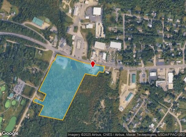
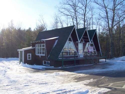
884 Kennedy Memorial Dr, Oakland, ME 04963

NEARBY LISTINGS FOR SALE OR LEASE
Property Detail
884 Kennedy Memorial Dr
OAKL-000005-000000-000089
Kennebec
Commercialnec
Maine
X
89
23011C0162D
1.40 AC
2024
Maine South & Augusta
2024
Other Market Areas
025002
Augusta-Waterville, ME
DEMOGRAPHICS near 884 Kennedy Memorial Dr
1 Mile
3 Mile
5 Mile
2024 Total Population
886
17,460
31,482
2029 Population
921
18,130
32,614
Pop Growth 2024-2029
+ 3.95%
+ 3.84%
+ 3.60%
Average Age
41
42
42
2024 Total Households
323
7,412
13,520
HH Growth 2024-2029
+ 4.02%
+ 3.90%
+ 3.65%
Median Household Inc
$70,603
$56,042
$54,481
Avg Household Size
2.20
2.10
2.10
2024 Avg HH Vehicles
2.00
2.00
2.00
Median Home Value
$221,428
$166,148
$171,786
Median Year Built
1990
1970
1970
Nearby Places
- Restaurants
- Banks
- Shops
- Fitness
- Groceries
Nearby Properties
Address
Land Use
TOTAL SIZE
Lot Size
Zoning
Address
Land Use
TOTAL SIZE
Lot Size
Zoning
115.09 AC
Address
Land Use
TOTAL SIZE
Lot Size
Zoning
Address
Land Use
TOTAL SIZE
Lot Size
Zoning
167,845 SF
33 AC
Address
Land Use
TOTAL SIZE
Lot Size
Zoning
2,388 SF
63.68 AC
SUBURB
Address
Land Use
TOTAL SIZE
Lot Size
Zoning
202,963 SF
25.73 AC
Address
Land Use
TOTAL SIZE
Lot Size
Zoning
174,750 SF
17.60 AC
Address
Land Use
TOTAL SIZE
Lot Size
Zoning
26.20 AC
HIGHWA
Address
Land Use
TOTAL SIZE
Lot Size
Zoning
20.88 AC
Address
Land Use
TOTAL SIZE
Lot Size
Zoning
71,838 SF
Address
Land Use
TOTAL SIZE
Lot Size
Zoning
10.25 AC
Address
Land Use
TOTAL SIZE
Lot Size
Zoning
Address
Land Use
TOTAL SIZE
Lot Size
Zoning
90,966 SF
26.70 AC
Address
Land Use
TOTAL SIZE
Lot Size
Zoning
12,516 SF
19.09 AC
Address
Land Use
TOTAL SIZE
Lot Size
Zoning
114,814 SF
10.37 AC
Address
Land Use
TOTAL SIZE
Lot Size
Zoning
46,400 SF
5.43 AC
ID
Address
Land Use
TOTAL SIZE
Lot Size
Zoning
Address
Land Use
TOTAL SIZE
Lot Size
Zoning
116,680 SF
16.20 AC
ID
Address
Land Use
TOTAL SIZE
Lot Size
Zoning
42,000 SF
4.98 AC
ID
Address
Land Use
TOTAL SIZE
Lot Size
Zoning
59,261 SF
56 AC
Address
Land Use
TOTAL SIZE
Lot Size
Zoning
92,224 SF
16.68 AC
Address
Land Use
TOTAL SIZE
Lot Size
Zoning
5.41 AC
DOWNTO
Address
Land Use
TOTAL SIZE
Lot Size
Zoning
20,410 SF
6.80 AC
HIGHWA
Address
Land Use
TOTAL SIZE
Lot Size
Zoning
36,194 SF
174 SF
Address
Land Use
TOTAL SIZE
Lot Size
Zoning
35,000 SF
4.58 AC
HIGHWA
Address
Land Use
TOTAL SIZE
Lot Size
Zoning
70,000 SF
12.54 AC
ID
Address
Land Use
TOTAL SIZE
Lot Size
Zoning
24.45 AC
Address
Land Use
TOTAL SIZE
Lot Size
Zoning
32,184 SF
5.10 AC
Address
Land Use
TOTAL SIZE
Lot Size
Zoning
46,578 SF
3.68 AC
Address
Land Use
TOTAL SIZE
Lot Size
Zoning
33,798 SF
1.55 AC
Address
Land Use
TOTAL SIZE
Lot Size
Zoning
52,927 SF
9.20 AC
DOWNTO
The World's #1 Commercial Real Estate Marketplace
Connect with us
© 2025 CoStar Group
The information above has been obtained from sources believed reliable. While we do not doubt its accuracy we have not verified it and make no guarantee, warranty or representation about it. It is your responsibility to independently confirm its accuracy and completeness. Any projections, opinions, assumptions, or estimates used are for example only and do not represent the current or future performance of the property. The value of this transaction to you depends on tax and other factors which should be evaluated by your tax, financial, and legal advisors. You and your advisors should conduct a careful, independent investigation of the property to determine to your satisfaction the suitability of the property for your needs.