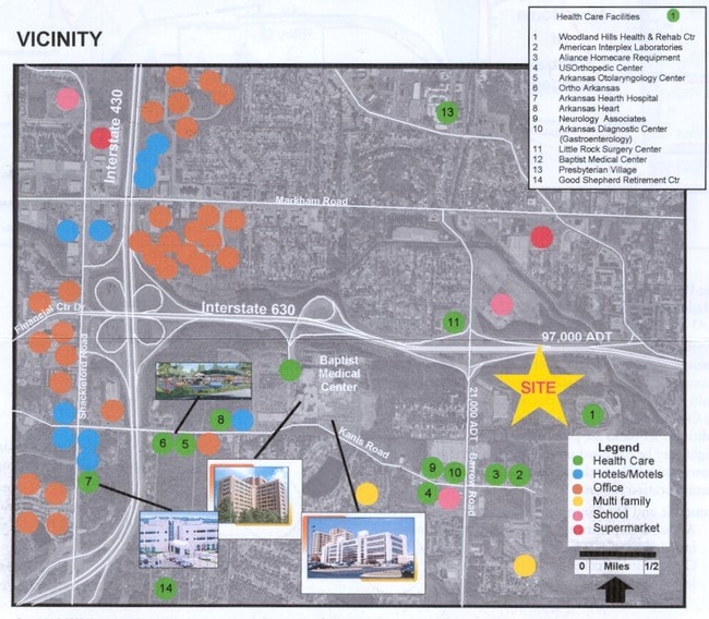
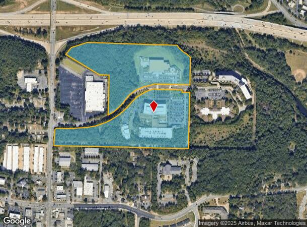
Property Record
8820 Carti Way, Little Rock, AR 72205
NEARBY LISTINGS FOR SALE OR LEASE
Property Detail
8820 Carti Way
44L-017-00-064-00
Kellwood
Hospitalpublic
W451.73 OF SW SE EXC BEG NW COR RILEYS REPLAT TR C KELLWOOD SUB S1*W158.29 TH N47*W72.44 N63*W55.9 N47*W74.33 N37*W48.98 TO NLN SW SE S88*E191.42 TO POB EXC PT SW SE SEC 2-1N-13W MPDA START SW COR OF SD SW SE TH S89*2156 E AL TH SLN OF SW SE 453.12
X
Pulaski
05119C0451H
Arkansas
2025
36.49 AC
2025
Midtown
002403
Little Rock/N Little Rock
227,729 SF
Little Rock-North Little Rock-Conway, AR
DEMOGRAPHICS near 8820 Carti Way
1 Mile
3 Mile
5 Mile
2024 Total Population
8,451
81,414
143,937
2029 Population
8,438
81,551
144,223
Pop Growth 2024-2029
(0.15%)
+ 0.17%
+ 0.20%
Average Age
39
39
39
2024 Total Households
3,831
37,145
63,827
HH Growth 2024-2029
(0.18%)
+ 0.20%
+ 0.19%
Median Household Inc
$43,597
$52,389
$53,561
Avg Household Size
2.10
2.10
2.10
2024 Avg HH Vehicles
1.00
2.00
2.00
Median Home Value
$153,346
$179,758
$188,105
Median Year Built
1973
1973
1975
Nearby Places
- Restaurants
- Banks
- Shops
- Fitness
- Groceries
PUBLIC TRANSPORTATION
COMMUTER RAIL
Little Rock Union Station (Texas Eagle - Amtrak)
DRIVE
WALK
Distance
Little Rock Union Station (Texas Eagle - Amtrak)
11 min
6.0 mi
AIRPORT
Bill and Hillary Clinton Ntl/Adams Field
DRIVE
WALK
Distance
Bill and Hillary Clinton Ntl/Adams Field
18 min
10.8 mi
Freight Ports
Port of Shreveport
DRIVE
WALK
Distance
Port of Shreveport
248 min
230.4 mi
Nearby Properties
Address
Land Use
TOTAL SIZE
Lot Size
Zoning
Address
Land Use
TOTAL SIZE
Lot Size
Zoning
4,400,000 SF
27.97 AC
Address
Land Use
TOTAL SIZE
Lot Size
Zoning
1,665,090 SF
34.75 AC
Address
Land Use
TOTAL SIZE
Lot Size
Zoning
1,909,430 SF
29.12 AC
Address
Land Use
TOTAL SIZE
Lot Size
Zoning
802,734 SF
22.99 AC
Address
Land Use
TOTAL SIZE
Lot Size
Zoning
956,566 SF
70.39 AC
Address
Land Use
TOTAL SIZE
Lot Size
Zoning
475,613 SF
10.14 AC
Address
Land Use
TOTAL SIZE
Lot Size
Zoning
603,434 SF
10.21 AC
Address
Land Use
TOTAL SIZE
Lot Size
Zoning
145,580 SF
19.89 AC
Address
Land Use
TOTAL SIZE
Lot Size
Zoning
39,635 SF
15.76 AC
Address
Land Use
TOTAL SIZE
Lot Size
Zoning
35,086 SF
6.48 AC
Address
Land Use
TOTAL SIZE
Lot Size
Zoning
220,563 SF
12.36 AC
Address
Land Use
TOTAL SIZE
Lot Size
Zoning
140,675 SF
Address
Land Use
TOTAL SIZE
Lot Size
Zoning
130,800 SF
7.78 AC
Address
Land Use
TOTAL SIZE
Lot Size
Zoning
221,911 SF
10.31 AC
Address
Land Use
TOTAL SIZE
Lot Size
Zoning
168,041 SF
29.22 AC
Address
Land Use
TOTAL SIZE
Lot Size
Zoning
57,494 SF
9.53 AC
Address
Land Use
TOTAL SIZE
Lot Size
Zoning
173,209 SF
26.54 AC
Address
Land Use
TOTAL SIZE
Lot Size
Zoning
19,142 SF
5.54 AC
Address
Land Use
TOTAL SIZE
Lot Size
Zoning
221,204 SF
4.54 AC
Address
Land Use
TOTAL SIZE
Lot Size
Zoning
318,188 SF
8.86 AC
Address
Land Use
TOTAL SIZE
Lot Size
Zoning
54,284 SF
11.33 AC
Address
Land Use
TOTAL SIZE
Lot Size
Zoning
63,244 SF
14.21 AC
Address
Land Use
TOTAL SIZE
Lot Size
Zoning
404,617 SF
9.51 AC
Address
Land Use
TOTAL SIZE
Lot Size
Zoning
185,873 SF
Address
Land Use
TOTAL SIZE
Lot Size
Zoning
78,004 SF
4.44 AC
Address
Land Use
TOTAL SIZE
Lot Size
Zoning
48,470 SF
26.37 AC
Address
Land Use
TOTAL SIZE
Lot Size
Zoning
74,220 SF
15.49 AC
Address
Land Use
TOTAL SIZE
Lot Size
Zoning
14,902 SF
5.04 AC
Address
Land Use
TOTAL SIZE
Lot Size
Zoning
122,775 SF
9.96 AC
The World's #1 Commercial Real Estate Marketplace
Connect with us
© 2025 CoStar Group
The information above has been obtained from sources believed reliable. While we do not doubt its accuracy we have not verified it and make no guarantee, warranty or representation about it. It is your responsibility to independently confirm its accuracy and completeness. Any projections, opinions, assumptions, or estimates used are for example only and do not represent the current or future performance of the property. The value of this transaction to you depends on tax and other factors which should be evaluated by your tax, financial, and legal advisors. You and your advisors should conduct a careful, independent investigation of the property to determine to your satisfaction the suitability of the property for your needs.