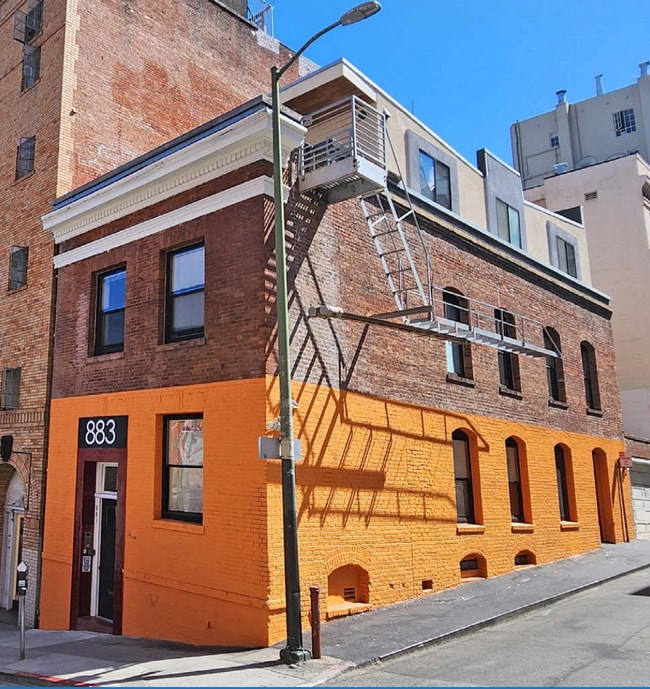
Property Record
883 Sacramento St, San Francisco, CA 94108
NEARBY LISTINGS FOR SALE OR LEASE
Property Detail
883 Sacramento St
San Francisco
50 Vara Bl 115
San Francisco-Redwood City-South San Francisco, CA
MAP A2 7
0242-025
San Francisco
Commercialofficeresidentialmixeduse
California
2024
25
2025
0.03 AC
011800
Chinatown
4,400 SF
DEMOGRAPHICS near 883 Sacramento St
1 Mile
3 Mile
5 Mile
2024 Total Population
129,758
392,652
624,572
2029 Population
120,807
366,399
579,654
Pop Growth 2024-2029
(6.90%)
(6.69%)
(7.19%)
Average Age
44
42
42
2024 Total Households
69,175
192,891
281,742
HH Growth 2024-2029
(7.46%)
(7.23%)
(7.61%)
Median Household Inc
$83,232
$127,257
$130,972
Avg Household Size
1.70
1.90
2.10
2024 Avg HH Vehicles
1.00
1.00
1.00
Median Home Value
$1,083,775
$1,097,991
$1,104,169
Median Year Built
1949
1950
1949
Nearby Places
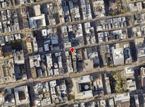
Map Layers
Map Styles
 Street
 Aerial
- Restaurants
- Banks
- Shops
- Fitness
- Groceries
PUBLIC TRANSPORTATION
TRANSIT/SUBWAY
California and Stockton (California Street Cable Car - San Francisco Municipal Railway (MUNI Metro))
DRIVE
WALK
Distance
California and Stockton (California Street Cable Car - San Francisco Municipal Railway (MUNI Metro))
1 min
2 min
0.1 mi
Powell and Sacramento (Powell-Hyde Cable Car - San Francisco Municipal Railway (MUNI Metro), Powell-Mason Cable Car - San Francisco Municipal Railway (MUNI Metro))
DRIVE
WALK
Distance
Powell and Sacramento (Powell-Hyde Cable Car - San Francisco Municipal Railway (MUNI Metro), Powell-Mason Cable Car - San Francisco Municipal Railway (MUNI Metro))
1 min
2 min
0.1 mi
California and Grant (California Street Cable Car - San Francisco Municipal Railway (MUNI Metro))
DRIVE
WALK
Distance
California and Grant (California Street Cable Car - San Francisco Municipal Railway (MUNI Metro))
1 min
3 min
0.2 mi
Powell and California (California Street Cable Car - San Francisco Municipal Railway (MUNI Metro), Powell-Hyde Cable Car - San Francisco Municipal Railway (MUNI Metro), Powell-Mason Cable Car - San Francisco Municipal Railway (MUNI Metro))
DRIVE
WALK
Distance
Powell and California (California Street Cable Car - San Francisco Municipal Railway (MUNI Metro), Powell-Hyde Cable Car - San Francisco Municipal Railway (MUNI Metro), Powell-Mason Cable Car - San Francisco Municipal Railway (MUNI Metro))
1 min
4 min
0.2 mi
Powell and Washington (Powell-Hyde Cable Car - San Francisco Municipal Railway (MUNI Metro), Powell-Mason Cable Car - San Francisco Municipal Railway (MUNI Metro))
DRIVE
WALK
Distance
Powell and Washington (Powell-Hyde Cable Car - San Francisco Municipal Railway (MUNI Metro), Powell-Mason Cable Car - San Francisco Municipal Railway (MUNI Metro))
1 min
5 min
0.2 mi
COMMUTER RAIL
San Francisco 4th & King (Caltrain - Caltrain (Caltrain))
DRIVE
WALK
Distance
San Francisco 4th & King (Caltrain - Caltrain (Caltrain))
4 min
1.5 mi
DRIVE
WALK
Distance
4 min
1.5 mi
AIRPORT
San Francisco International
DRIVE
WALK
Distance
San Francisco International
23 min
14.5 mi
Metro Oakland International
DRIVE
WALK
Distance
Metro Oakland International
31 min
19.6 mi
Norman Y Mineta San Jose International
DRIVE
WALK
Distance
Norman Y Mineta San Jose International
59 min
46.1 mi
Freight Ports
Port of San Francisco
DRIVE
WALK
Distance
Port of San Francisco
3 min
1.2 mi
SALE & LEASE HISTORY
LISTING DATE
SALE/LEASE

Sep 25, 2025
For Sale
Oct 17, 2022
For Lease
Mar 31, 2025
For Sale
Mar 21, 2019
For Lease
Mar 20, 2018
For Sale
Jan 10, 2018
For Sale
Jan 08, 2018
For Sale
Aug 20, 2019
For Lease
Apr 17, 2019
For Lease
Nearby Properties
Address
Land Use
TOTAL SIZE
Lot Size
Zoning
Address
Land Use
TOTAL SIZE
Lot Size
Zoning
1,015,000 SF
2.43 AC
RC4
Address
Land Use
TOTAL SIZE
Lot Size
Zoning
764,661 SF
0.67 AC
C3OSD
Address
Land Use
TOTAL SIZE
Lot Size
Zoning
750,370 SF
3.25 AC
MBR3
Address
Land Use
TOTAL SIZE
Lot Size
Zoning
1,471,929 SF
1.93 AC
C3O
Address
Land Use
TOTAL SIZE
Lot Size
Zoning
1,300,000 SF
1.74 AC
C3O
Address
Land Use
TOTAL SIZE
Lot Size
Zoning
1,420,430 SF
1.16 AC
C3OSD
Address
Land Use
TOTAL SIZE
Lot Size
Zoning
1,534,312 SF
2.60 AC
C3O
Address
Land Use
TOTAL SIZE
Lot Size
Zoning
914,037 SF
1.36 AC
C3O
Address
Land Use
TOTAL SIZE
Lot Size
Zoning
717,234 SF
3.47 AC
UMU
Address
Land Use
TOTAL SIZE
Lot Size
Zoning
605,459 SF
0.63 AC
C3O
Address
Land Use
TOTAL SIZE
Lot Size
Zoning
475,791 SF
0.55 AC
C3OSD
Address
Land Use
TOTAL SIZE
Lot Size
Zoning
690,442 SF
0.79 AC
C3O
Address
Land Use
TOTAL SIZE
Lot Size
Zoning
10.92 AC
Address
Land Use
TOTAL SIZE
Lot Size
Zoning
750,491 SF
0.51 AC
C3O
Address
Land Use
TOTAL SIZE
Lot Size
Zoning
432,000 SF
0.35 AC
C3OSD
Address
Land Use
TOTAL SIZE
Lot Size
Zoning
266,143 SF
4 AC
C-3-R
Address
Land Use
TOTAL SIZE
Lot Size
Zoning
885,581 SF
5.20 AC
M2
Address
Land Use
TOTAL SIZE
Lot Size
Zoning
512,395 SF
1.24 AC
C3O
Address
Land Use
TOTAL SIZE
Lot Size
Zoning
508,714 SF
1.29 AC
C3R
Address
Land Use
TOTAL SIZE
Lot Size
Zoning
1,084,662 SF
1.67 AC
C3O
Address
Land Use
TOTAL SIZE
Lot Size
Zoning
505,120 SF
0.41 AC
C3O
Address
Land Use
TOTAL SIZE
Lot Size
Zoning
694,334 SF
1.01 AC
C3O
Address
Land Use
TOTAL SIZE
Lot Size
Zoning
696,431 SF
0.97 AC
C3G
Address
Land Use
TOTAL SIZE
Lot Size
Zoning
139,070 SF
0.64 AC
C3O
Address
Land Use
TOTAL SIZE
Lot Size
Zoning
1.52 AC
C3G
Address
Land Use
TOTAL SIZE
Lot Size
Zoning
1,424,230 SF
2.60 AC
C3G
Address
Land Use
TOTAL SIZE
Lot Size
Zoning
614,740 SF
1.74 AC
C3OSD
Address
Land Use
TOTAL SIZE
Lot Size
Zoning
615,957 SF
0.63 AC
C3O
Address
Land Use
TOTAL SIZE
Lot Size
Zoning
492,980 SF
0.43 AC
C3O
Address
Land Use
TOTAL SIZE
Lot Size
Zoning
385,000 SF
0.81 AC
C3O
The World's #1 Commercial Real Estate Marketplace
Connect with us
© 2026 CoStar Group
The information above has been obtained from sources believed reliable. While we do not doubt its accuracy we have not verified it and make no guarantee, warranty or representation about it. It is your responsibility to independently confirm its accuracy and completeness. Any projections, opinions, assumptions, or estimates used are for example only and do not represent the current or future performance of the property. The value of this transaction to you depends on tax and other factors which should be evaluated by your tax, financial, and legal advisors. You and your advisors should conduct a careful, independent investigation of the property to determine to your satisfaction the suitability of the property for your needs.