Property Record
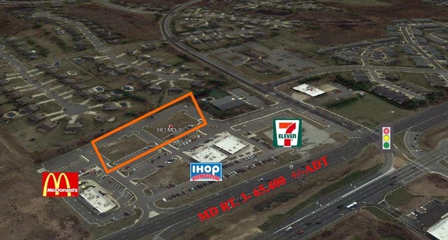
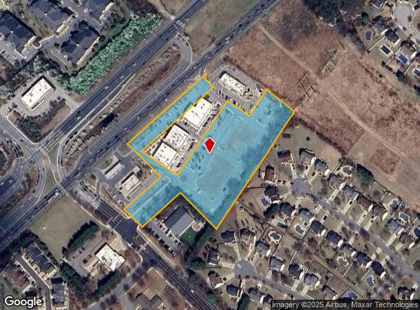
883 State Route 3 N, Gambrills, MD 21054
NEARBY LISTINGS FOR SALE OR LEASE
Property Detail
883 State Route 3 N
Baltimore-Columbia-Towson, MD
Main St At Waugh Chapel
02-000-90227798
LT 1R MAIN ST AT WAUGH CHAPEL
Commercialacreage
Anne Arundel
X
Maryland
24003C0145E
1r
2024
4.88 AC
2025
I-97/Crain Hwy Corridor
702208
Baltimore
DEMOGRAPHICS near 883 State Route 3 N
1 Mile
3 Mile
5 Mile
2024 Total Population
9,907
52,388
94,303
2029 Population
10,142
53,568
96,442
Pop Growth 2024-2029
+ 2.37%
+ 2.25%
+ 2.27%
Average Age
37
38
39
2024 Total Households
3,668
19,224
35,481
HH Growth 2024-2029
+ 2.54%
+ 2.41%
+ 2.50%
Median Household Inc
$122,629
$127,623
$124,593
Avg Household Size
2.70
2.70
2.60
2024 Avg HH Vehicles
2.00
2.00
2.00
Median Home Value
$389,013
$443,262
$453,291
Median Year Built
1997
1991
1992
Nearby Places
Map Layers
Map Styles
 Street
 Aerial
- Restaurants
- Banks
- Shops
- Fitness
- Groceries
PUBLIC TRANSPORTATION
COMMUTER RAIL
Odenton (Penn Line - Maryland Area Regional Commuter Trains (The MARC))
DRIVE
WALK
Distance
Odenton (Penn Line - Maryland Area Regional Commuter Trains (The MARC))
11 min
5.2 mi
DRIVE
WALK
Distance
20 min
9.5 mi
AIRPORT
Baltimore/Washington International Thurgood Marshall
DRIVE
WALK
Distance
Baltimore/Washington International Thurgood Marshall
23 min
14.9 mi
Ronald Reagan Washington Ntl
DRIVE
WALK
Distance
Ronald Reagan Washington Ntl
45 min
29.9 mi
Freight Ports
Port of Baltimore
DRIVE
WALK
Distance
Port of Baltimore
29 min
20.2 mi
SALE & LEASE HISTORY
LISTING DATE
SALE/LEASE

Jul 30, 2018
For Lease
Jul 27, 2018
For Sale
Nearby Properties
Address
Land Use
TOTAL SIZE
Lot Size
Zoning
Address
Land Use
TOTAL SIZE
Lot Size
Zoning
444,842 SF
19.48 AC
R22
Address
Land Use
TOTAL SIZE
Lot Size
Zoning
360,354 SF
7.36 AC
MXD-C
Address
Land Use
TOTAL SIZE
Lot Size
Zoning
246,000 SF
15.73 AC
MXDR
Address
Land Use
TOTAL SIZE
Lot Size
Zoning
273,816 SF
44.22 AC
MXD-C
Address
Land Use
TOTAL SIZE
Lot Size
Zoning
14.65 AC
R15
Address
Land Use
TOTAL SIZE
Lot Size
Zoning
311,870 SF
10.03 AC
Address
Land Use
TOTAL SIZE
Lot Size
Zoning
8.70 AC
R15
Address
Land Use
TOTAL SIZE
Lot Size
Zoning
237,377 SF
9.86 AC
R15
Address
Land Use
TOTAL SIZE
Lot Size
Zoning
265,645 SF
12.79 AC
R15
Address
Land Use
TOTAL SIZE
Lot Size
Zoning
159,944 SF
5.34 AC
C1
Address
Land Use
TOTAL SIZE
Lot Size
Zoning
125.95 AC
R5
Address
Land Use
TOTAL SIZE
Lot Size
Zoning
155,269 SF
13.27 AC
O-EOD
Address
Land Use
TOTAL SIZE
Lot Size
Zoning
8.38 AC
R22
Address
Land Use
TOTAL SIZE
Lot Size
Zoning
108,480 SF
17.66 AC
C4
Address
Land Use
TOTAL SIZE
Lot Size
Zoning
72,925 SF
4.12 AC
MXR
Address
Land Use
TOTAL SIZE
Lot Size
Zoning
43,842 SF
27.74 AC
C4
Address
Land Use
TOTAL SIZE
Lot Size
Zoning
47,744 SF
1.79 AC
MXD-C
Address
Land Use
TOTAL SIZE
Lot Size
Zoning
39,695 SF
11.66 AC
C4
Address
Land Use
TOTAL SIZE
Lot Size
Zoning
111,450 SF
154.81 AC
R1
Address
Land Use
TOTAL SIZE
Lot Size
Zoning
134,923 SF
8.35 AC
MXD-C
Address
Land Use
TOTAL SIZE
Lot Size
Zoning
86,496 SF
6.86 AC
R5
Address
Land Use
TOTAL SIZE
Lot Size
Zoning
87,919 SF
9.71 AC
R5
Address
Land Use
TOTAL SIZE
Lot Size
Zoning
112,028 SF
40.41 AC
R1
Address
Land Use
TOTAL SIZE
Lot Size
Zoning
63,000 SF
22.90 AC
R1
Address
Land Use
TOTAL SIZE
Lot Size
Zoning
29,161 SF
3.98 AC
MXD-C
Address
Land Use
TOTAL SIZE
Lot Size
Zoning
70,784 SF
18 AC
R15
Address
Land Use
TOTAL SIZE
Lot Size
Zoning
91,592 SF
9.51 AC
C3
Address
Land Use
TOTAL SIZE
Lot Size
Zoning
58,512 SF
3.91 AC
O-EOD
Address
Land Use
TOTAL SIZE
Lot Size
Zoning
78,930 SF
9.24 AC
R5
Address
Land Use
TOTAL SIZE
Lot Size
Zoning
74,054 SF
1.40 AC
R1
The World's #1 Commercial Real Estate Marketplace
Connect with us
© 2025 CoStar Group
The information above has been obtained from sources believed reliable. While we do not doubt its accuracy we have not verified it and make no guarantee, warranty or representation about it. It is your responsibility to independently confirm its accuracy and completeness. Any projections, opinions, assumptions, or estimates used are for example only and do not represent the current or future performance of the property. The value of this transaction to you depends on tax and other factors which should be evaluated by your tax, financial, and legal advisors. You and your advisors should conduct a careful, independent investigation of the property to determine to your satisfaction the suitability of the property for your needs.