Property Record
8836 Montana Ave, El Paso, TX 79925
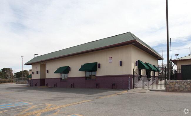
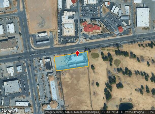
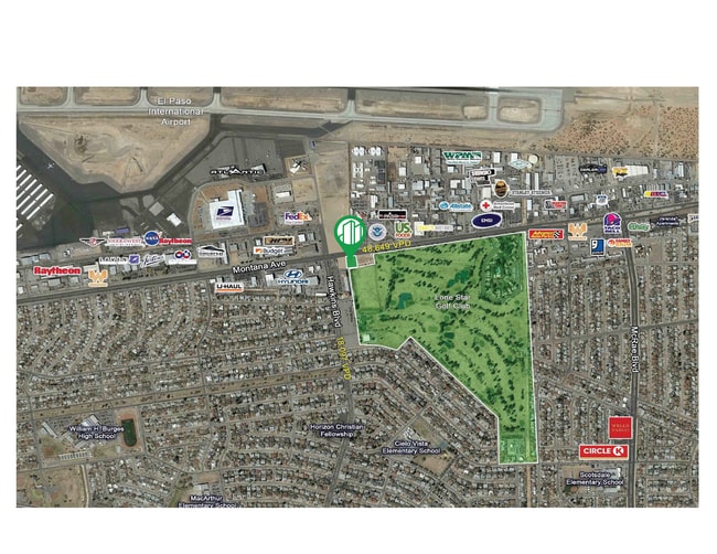
This Property Is For Sale
NEARBY LISTINGS FOR SALE OR LEASE
Property Detail
8836 Montana Ave
El Paso, TX
2 ASCARATE POSS INT ACCT TR1-B & 3-A OUT OF BLK 80 TSP 2 SEC 40 & PT OF MOREHOUSE SURV 12 (2.062 AC)
A765-999-002A-0103
El Paso
Commercialnec
Texas
2024
2.06 AC
2025
East
003404
El Paso
6,258 SF
DEMOGRAPHICS near 8836 Montana Ave
1 Mile
3 Mile
5 Mile
2024 Total Population
7,676
72,208
195,398
2029 Population
7,718
72,731
197,303
Pop Growth 2024-2029
+ 0.55%
+ 0.72%
+ 0.97%
Average Age
42
38
39
2024 Total Households
3,043
26,250
70,850
HH Growth 2024-2029
+ 0.59%
+ 0.69%
+ 0.90%
Median Household Inc
$66,171
$49,541
$44,199
Avg Household Size
2.50
2.50
2.60
2024 Avg HH Vehicles
2.00
2.00
2.00
Median Home Value
$174,724
$152,834
$142,110
Median Year Built
1963
1971
1972
Nearby Places
- Restaurants
- Banks
- Shops
- Fitness
- Groceries
PUBLIC TRANSPORTATION
AIRPORT
El Paso International
DRIVE
WALK
Distance
El Paso International
16 min
6.3 mi
Freight Ports
Port of Corpus Christi
DRIVE
WALK
Distance
Port of Corpus Christi
677 min
689.9 mi
Nearby Properties
Address
Land Use
TOTAL SIZE
Lot Size
Zoning
Address
Land Use
TOTAL SIZE
Lot Size
Zoning
75,601 SF
495.64 AC
M3
Address
Land Use
TOTAL SIZE
Lot Size
Zoning
600,211 SF
114.73 AC
RF
Address
Land Use
TOTAL SIZE
Lot Size
Zoning
753,996 SF
23.50 AC
C4
Address
Land Use
TOTAL SIZE
Lot Size
Zoning
1,527,480 SF
201.94 AC
Address
Land Use
TOTAL SIZE
Lot Size
Zoning
1,122,782 SF
55.24 AC
C4
Address
Land Use
TOTAL SIZE
Lot Size
Zoning
561,866 SF
27.25 AC
C4
Address
Land Use
TOTAL SIZE
Lot Size
Zoning
1 SF
214 AC
M3
Address
Land Use
TOTAL SIZE
Lot Size
Zoning
380,811 SF
22.75 AC
M1
Address
Land Use
TOTAL SIZE
Lot Size
Zoning
343,190 SF
31.84 AC
C4
Address
Land Use
TOTAL SIZE
Lot Size
Zoning
259,926 SF
250.23 AC
M1
Address
Land Use
TOTAL SIZE
Lot Size
Zoning
107.76 AC
C4
Address
Land Use
TOTAL SIZE
Lot Size
Zoning
289.07 AC
Address
Land Use
TOTAL SIZE
Lot Size
Zoning
374,839 SF
33.29 AC
C3S
Address
Land Use
TOTAL SIZE
Lot Size
Zoning
683,161 SF
M1
Address
Land Use
TOTAL SIZE
Lot Size
Zoning
135,639 SF
211.63 AC
C4
Address
Land Use
TOTAL SIZE
Lot Size
Zoning
273.45 AC
M1
Address
Land Use
TOTAL SIZE
Lot Size
Zoning
377,168 SF
8.40 AC
C1
Address
Land Use
TOTAL SIZE
Lot Size
Zoning
195,101 SF
15.45 AC
C1
Address
Land Use
TOTAL SIZE
Lot Size
Zoning
271,746 SF
1.93 AC
C4
Address
Land Use
TOTAL SIZE
Lot Size
Zoning
190,770 SF
8.70 AC
C4S
Address
Land Use
TOTAL SIZE
Lot Size
Zoning
210,541 SF
2.45 AC
C3S
Address
Land Use
TOTAL SIZE
Lot Size
Zoning
201.94 AC
Address
Land Use
TOTAL SIZE
Lot Size
Zoning
74,907 SF
8.07 AC
C4
Address
Land Use
TOTAL SIZE
Lot Size
Zoning
142,532 SF
13.32 AC
C3S
Address
Land Use
TOTAL SIZE
Lot Size
Zoning
495,319 SF
36.42 AC
M1
Address
Land Use
TOTAL SIZE
Lot Size
Zoning
435.51 AC
Address
Land Use
TOTAL SIZE
Lot Size
Zoning
196,860 SF
10.15 AC
C4
Address
Land Use
TOTAL SIZE
Lot Size
Zoning
272,601 SF
14.97 AC
AO
Address
Land Use
TOTAL SIZE
Lot Size
Zoning
197,902 SF
30 AC
R4
Address
Land Use
TOTAL SIZE
Lot Size
Zoning
184,016 SF
14.17 AC
C4
The World's #1 Commercial Real Estate Marketplace
Connect with us
© 2025 CoStar Group
The information above has been obtained from sources believed reliable. While we do not doubt its accuracy we have not verified it and make no guarantee, warranty or representation about it. It is your responsibility to independently confirm its accuracy and completeness. Any projections, opinions, assumptions, or estimates used are for example only and do not represent the current or future performance of the property. The value of this transaction to you depends on tax and other factors which should be evaluated by your tax, financial, and legal advisors. You and your advisors should conduct a careful, independent investigation of the property to determine to your satisfaction the suitability of the property for your needs.