Property Record
884 W State Road 436, Altamonte Springs, FL 32714

NEARBY LISTINGS FOR SALE OR LEASE
Property Detail
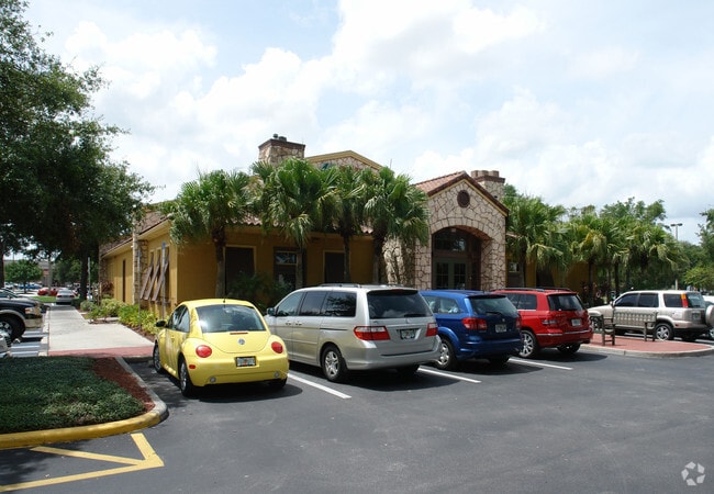
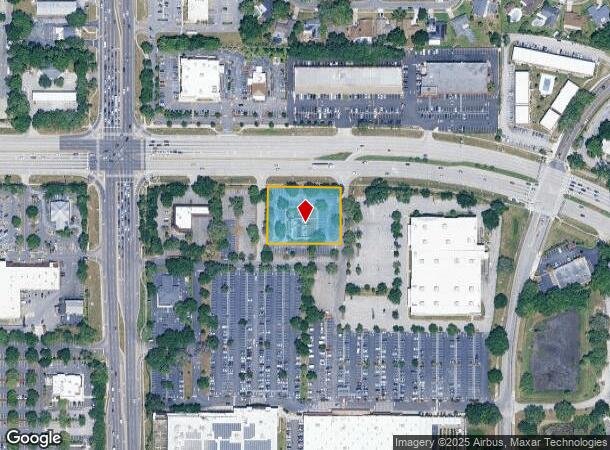
884 W State Road 436
Orlando-Kissimmee-Sanford, FL
Altamonte Center
16-21-29-513-0000-0020
LOT 2 ALTAMONTE CROSSING PB 44 PGS 90 & 91
Restaurantbuilding
Seminole
X
Florida
12095C0145F
2
2024
1.13 AC
2024
Maitland Center
021705
Orlando
7,103 SF
DEMOGRAPHICS near 884 W State Road 436
1 Mile
3 Mile
5 Mile
2024 Total Population
14,486
108,420
226,438
2029 Population
15,002
112,911
234,793
Pop Growth 2024-2029
+ 3.56%
+ 4.14%
+ 3.69%
Average Age
40
41
41
2024 Total Households
5,814
45,688
91,310
HH Growth 2024-2029
+ 3.65%
+ 4.36%
+ 3.89%
Median Household Inc
$56,315
$64,092
$62,075
Avg Household Size
2.40
2.30
2.40
2024 Avg HH Vehicles
2.00
2.00
2.00
Median Home Value
$265,201
$310,077
$299,290
Median Year Built
1981
1983
1983
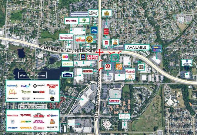
Nearby Places
- Restaurants
- Banks
- Shops
- Fitness
- Groceries
PUBLIC TRANSPORTATION
AIRPORT
Orlando Sanford International
DRIVE
WALK
Distance
Orlando Sanford International
27 min
21.0 mi
Orlando International
DRIVE
WALK
Distance
Orlando International
36 min
24.1 mi
SALE & LEASE HISTORY
LISTING DATE
SALE/LEASE

Nov 29, 2017
For Sale
Jun 25, 2020
For Sale
Jul 06, 2017
For Lease
Jul 02, 2019
For Sale
Feb 19, 2025
For Lease
Nearby Properties
Address
Land Use
TOTAL SIZE
Lot Size
Zoning
Address
Land Use
TOTAL SIZE
Lot Size
Zoning
1,009,074 SF
37.77 AC
PD
Address
Land Use
TOTAL SIZE
Lot Size
Zoning
630,861 SF
31.67 AC
PUDMO
Address
Land Use
TOTAL SIZE
Lot Size
Zoning
88,256 SF
39.64 AC
MOC3
Address
Land Use
TOTAL SIZE
Lot Size
Zoning
423,270 SF
3.45 AC
MOC3
Address
Land Use
TOTAL SIZE
Lot Size
Zoning
745,187 SF
18 AC
PUD
Address
Land Use
TOTAL SIZE
Lot Size
Zoning
34,430 SF
19.99 AC
Address
Land Use
TOTAL SIZE
Lot Size
Zoning
1,674 SF
10.53 AC
R3
Address
Land Use
TOTAL SIZE
Lot Size
Zoning
129,745 SF
71.01 AC
PUD
Address
Land Use
TOTAL SIZE
Lot Size
Zoning
357 SF
17.05 AC
Address
Land Use
TOTAL SIZE
Lot Size
Zoning
384,447 SF
10.70 AC
P-D
Address
Land Use
TOTAL SIZE
Lot Size
Zoning
Address
Land Use
TOTAL SIZE
Lot Size
Zoning
468,719 SF
45.46 AC
PD
Address
Land Use
TOTAL SIZE
Lot Size
Zoning
1,416 SF
23.80 AC
Address
Land Use
TOTAL SIZE
Lot Size
Zoning
391,714 SF
42.59 AC
A1
Address
Land Use
TOTAL SIZE
Lot Size
Zoning
381,557 SF
10.09 AC
PD
Address
Land Use
TOTAL SIZE
Lot Size
Zoning
400 SF
13.82 AC
R1AA
Address
Land Use
TOTAL SIZE
Lot Size
Zoning
5,256 SF
1.10 AC
PUDRES
Address
Land Use
TOTAL SIZE
Lot Size
Zoning
231,070 SF
35.59 AC
MOR2
Address
Land Use
TOTAL SIZE
Lot Size
Zoning
11,392 SF
8.44 AC
Address
Land Use
TOTAL SIZE
Lot Size
Zoning
631,978 SF
7 AC
PD
Address
Land Use
TOTAL SIZE
Lot Size
Zoning
385,111 SF
12.39 AC
PD
Address
Land Use
TOTAL SIZE
Lot Size
Zoning
1,428 SF
8.56 AC
MOR3
Address
Land Use
TOTAL SIZE
Lot Size
Zoning
1,170 SF
17.75 AC
A1
Address
Land Use
TOTAL SIZE
Lot Size
Zoning
269,919 SF
24.44 AC
R-3
Address
Land Use
TOTAL SIZE
Lot Size
Zoning
5,913 SF
14.46 AC
Address
Land Use
TOTAL SIZE
Lot Size
Zoning
779,046 SF
14.36 AC
PD
Address
Land Use
TOTAL SIZE
Lot Size
Zoning
447,386 SF
5.73 AC
PD
Address
Land Use
TOTAL SIZE
Lot Size
Zoning
254,477 SF
13.14 AC
MOR2
Address
Land Use
TOTAL SIZE
Lot Size
Zoning
268,195 SF
50.24 AC
O
Address
Land Use
TOTAL SIZE
Lot Size
Zoning
5,924 SF
17.38 AC
R1A
The World's #1 Commercial Real Estate Marketplace
Connect with us
© 2025 CoStar Group
The information above has been obtained from sources believed reliable. While we do not doubt its accuracy we have not verified it and make no guarantee, warranty or representation about it. It is your responsibility to independently confirm its accuracy and completeness. Any projections, opinions, assumptions, or estimates used are for example only and do not represent the current or future performance of the property. The value of this transaction to you depends on tax and other factors which should be evaluated by your tax, financial, and legal advisors. You and your advisors should conduct a careful, independent investigation of the property to determine to your satisfaction the suitability of the property for your needs.