Property Record
8845 41St Ave, Kenosha, WI 53142


NEARBY LISTINGS FOR SALE OR LEASE
-
-
View all Kenosha listings for sale on LoopNet.com
Property Detail
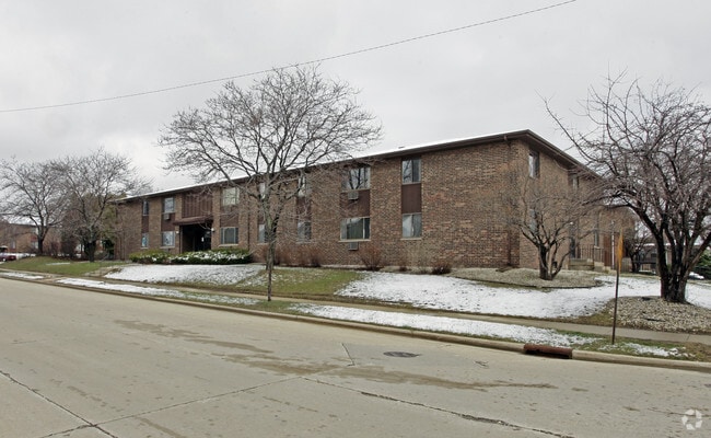
8845 41St Ave
Chicago-Naperville-Elgin, IL-IN-WI
Isetts Est
04-122-14-179-001
LOT 308 ISETTS ESTATES 8TH ADD PT NE 1/4 SEC 14 T 1 R 22 V 1407 P 60 V 1605 P 316 DOC#1166133 DOC#1169460 (CORRECTION) DOC#12
Commercialnec
Kenosha
X
Wisconsin
55059C0211D
308
2024
0.55 AC
2024
Outlying Kenosha County
002400
Chicago
12,672 SF
DEMOGRAPHICS near 8845 41St Ave
1 Mile
3 Mile
5 Mile
2024 Total Population
6,516
61,201
112,485
2029 Population
6,478
60,475
111,263
Pop Growth 2024-2029
(0.58%)
(1.19%)
(1.09%)
Average Age
45
40
39
2024 Total Households
2,789
24,020
43,834
HH Growth 2024-2029
(0.72%)
(1.24%)
(1.11%)
Median Household Inc
$85,159
$69,831
$68,991
Avg Household Size
2.30
2.50
2.40
2024 Avg HH Vehicles
2.00
2.00
2.00
Median Home Value
$269,345
$204,447
$215,644
Median Year Built
1976
1965
1971
Nearby Places
Map Layers
Map Styles
 Street
 Aerial
- Restaurants
- Banks
- Shops
- Fitness
- Groceries
PUBLIC TRANSPORTATION
COMMUTER RAIL
Kenosha Station (Union Pacific North Line - Northeast Illinois Regional Commuter Railroad (Metra))
DRIVE
WALK
Distance
Kenosha Station (Union Pacific North Line - Northeast Illinois Regional Commuter Railroad (Metra))
9 min
4.4 mi
Winthrop Harbor Station (Union Pacific North Line - Northeast Illinois Regional Commuter Railroad (Metra))
DRIVE
WALK
Distance
Winthrop Harbor Station (Union Pacific North Line - Northeast Illinois Regional Commuter Railroad (Metra))
13 min
6.3 mi
AIRPORT
General Mitchell International
DRIVE
WALK
Distance
General Mitchell International
46 min
34.7 mi
Freight Ports
Port Milwaukee
DRIVE
WALK
Distance
Port Milwaukee
50 min
38.5 mi
SALE & LEASE HISTORY
LISTING DATE
SALE/LEASE

Sep 24, 2016
For Sale
Nearby Properties
Address
Land Use
TOTAL SIZE
Lot Size
Zoning
Address
Land Use
TOTAL SIZE
Lot Size
Zoning
271,533 SF
125.41 AC
Address
Land Use
TOTAL SIZE
Lot Size
Zoning
176,386 SF
58.38 AC
Address
Land Use
TOTAL SIZE
Lot Size
Zoning
603,010 SF
51.30 AC
Address
Land Use
TOTAL SIZE
Lot Size
Zoning
69,139 SF
12.40 AC
Address
Land Use
TOTAL SIZE
Lot Size
Zoning
424,072 SF
29.14 AC
Address
Land Use
TOTAL SIZE
Lot Size
Zoning
302,500 SF
23.89 AC
Address
Land Use
TOTAL SIZE
Lot Size
Zoning
194,611 SF
16.67 AC
Address
Land Use
TOTAL SIZE
Lot Size
Zoning
215,460 SF
40.08 AC
Address
Land Use
TOTAL SIZE
Lot Size
Zoning
35,092 SF
26.34 AC
B2
Address
Land Use
TOTAL SIZE
Lot Size
Zoning
4,643 SF
60 AC
Address
Land Use
TOTAL SIZE
Lot Size
Zoning
15.32 AC
Address
Land Use
TOTAL SIZE
Lot Size
Zoning
253,256 SF
15.22 AC
Address
Land Use
TOTAL SIZE
Lot Size
Zoning
256,810 SF
15.02 AC
Address
Land Use
TOTAL SIZE
Lot Size
Zoning
1,200 SF
50.46 AC
Address
Land Use
TOTAL SIZE
Lot Size
Zoning
2,963 SF
13.16 AC
Address
Land Use
TOTAL SIZE
Lot Size
Zoning
14.40 AC
Address
Land Use
TOTAL SIZE
Lot Size
Zoning
176,830 SF
11.15 AC
Address
Land Use
TOTAL SIZE
Lot Size
Zoning
194,281 SF
19.13 AC
B2
Address
Land Use
TOTAL SIZE
Lot Size
Zoning
113,616 SF
29.22 AC
Address
Land Use
TOTAL SIZE
Lot Size
Zoning
10.37 AC
IP
Address
Land Use
TOTAL SIZE
Lot Size
Zoning
5.03 AC
RM2
Address
Land Use
TOTAL SIZE
Lot Size
Zoning
149,620 SF
9.54 AC
Address
Land Use
TOTAL SIZE
Lot Size
Zoning
150,337 SF
8.77 AC
Address
Land Use
TOTAL SIZE
Lot Size
Zoning
23,980 SF
4.02 AC
Address
Land Use
TOTAL SIZE
Lot Size
Zoning
357,885 SF
26.58 AC
M1
Address
Land Use
TOTAL SIZE
Lot Size
Zoning
76,848 SF
8.09 AC
BASE
Address
Land Use
TOTAL SIZE
Lot Size
Zoning
161,640 SF
14.88 AC
B2
Address
Land Use
TOTAL SIZE
Lot Size
Zoning
148,600 SF
8.21 AC
Address
Land Use
TOTAL SIZE
Lot Size
Zoning
143,872 SF
10.84 AC
Address
Land Use
TOTAL SIZE
Lot Size
Zoning
17,174 SF
10.31 AC
RS2
The World's #1 Commercial Real Estate Marketplace
Connect with us
© 2025 CoStar Group
The information above has been obtained from sources believed reliable. While we do not doubt its accuracy we have not verified it and make no guarantee, warranty or representation about it. It is your responsibility to independently confirm its accuracy and completeness. Any projections, opinions, assumptions, or estimates used are for example only and do not represent the current or future performance of the property. The value of this transaction to you depends on tax and other factors which should be evaluated by your tax, financial, and legal advisors. You and your advisors should conduct a careful, independent investigation of the property to determine to your satisfaction the suitability of the property for your needs.