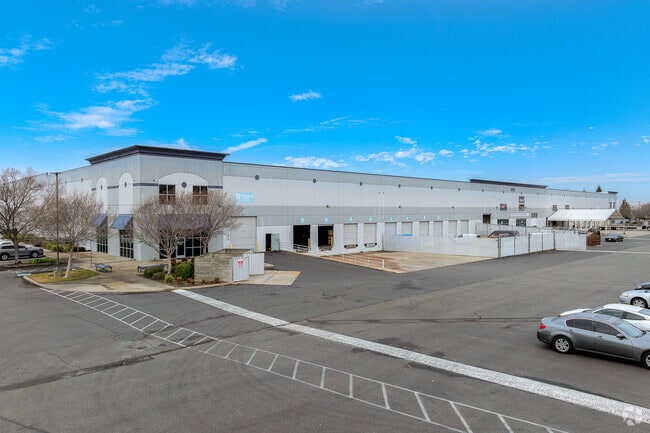
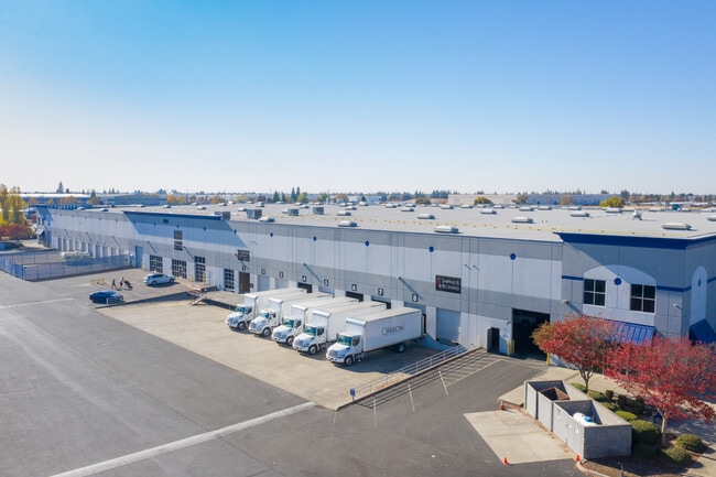
Property Record
8845 Washington Blvd, Roseville, CA 95678


Current Lease Availabilities
NEARBY LISTINGS FOR SALE OR LEASE
Property Detail
8845 Washington Blvd
Sacramento-Roseville-Folsom, CA
Northgate Bus Park 67
017-113-022
11.7 AC PAR C PMOR 30-124
Warehouse
Placer
X
California
06061C0941H
92-94
2023
11.70 AC
2023
Roseville/Rocklin
021034
Sacramento
216,000 SF
DEMOGRAPHICS near 8845 Washington Blvd
1 Mile
3 Mile
5 Mile
2024 Total Population
6,337
107,421
231,765
2029 Population
6,830
115,293
249,747
Pop Growth 2024-2029
+ 7.78%
+ 7.33%
+ 7.76%
Average Age
38
40
40
2024 Total Households
2,221
39,260
84,174
HH Growth 2024-2029
+ 8.06%
+ 7.36%
+ 7.76%
Median Household Inc
$128,963
$108,643
$109,862
Avg Household Size
2.80
2.70
2.70
2024 Avg HH Vehicles
2.00
2.00
2.00
Median Home Value
$615,148
$637,358
$649,233
Median Year Built
2000
1997
1999
Nearby Places
Map Layers
Map Styles
 Street
 Aerial
- Restaurants
- Banks
- Shops
- Fitness
- Groceries
PUBLIC TRANSPORTATION
COMMUTER RAIL
Roseville (California Zephyr - Amtrak, Capitol Corridor - Amtrak)
DRIVE
WALK
Distance
Roseville (California Zephyr - Amtrak, Capitol Corridor - Amtrak)
8 min
3.6 mi
Rocklin Amtrak Station (Capitol Corridor - Amtrak)
DRIVE
WALK
Distance
Rocklin Amtrak Station (Capitol Corridor - Amtrak)
12 min
7.0 mi
AIRPORT
Sacramento International
DRIVE
WALK
Distance
Sacramento International
40 min
25.5 mi
Freight Ports
Port of Stockton
DRIVE
WALK
Distance
Port of Stockton
84 min
70.7 mi
Nearby Properties
Address
Land Use
TOTAL SIZE
Lot Size
Zoning
Address
Land Use
TOTAL SIZE
Lot Size
Zoning
678,494 SF
15.80 AC
Address
Land Use
TOTAL SIZE
Lot Size
Zoning
341,145 SF
12 AC
Address
Land Use
TOTAL SIZE
Lot Size
Zoning
471,741 SF
15.14 AC
Address
Land Use
TOTAL SIZE
Lot Size
Zoning
280,129 SF
14.90 AC
Address
Land Use
TOTAL SIZE
Lot Size
Zoning
401,656 SF
28 AC
Address
Land Use
TOTAL SIZE
Lot Size
Zoning
130,228 SF
11.10 AC
Address
Land Use
TOTAL SIZE
Lot Size
Zoning
325,462 SF
29.50 AC
Address
Land Use
TOTAL SIZE
Lot Size
Zoning
328,416 SF
17.80 AC
Address
Land Use
TOTAL SIZE
Lot Size
Zoning
1,032,692 SF
81.30 AC
INPDC
Address
Land Use
TOTAL SIZE
Lot Size
Zoning
174,840 SF
19.70 AC
Address
Land Use
TOTAL SIZE
Lot Size
Zoning
243,765 SF
14.24 AC
Address
Land Use
TOTAL SIZE
Lot Size
Zoning
144,760 SF
26.70 AC
Address
Land Use
TOTAL SIZE
Lot Size
Zoning
222,702 SF
10.57 AC
Address
Land Use
TOTAL SIZE
Lot Size
Zoning
769,698 SF
50.39 AC
Address
Land Use
TOTAL SIZE
Lot Size
Zoning
411,344 SF
41.50 AC
Address
Land Use
TOTAL SIZE
Lot Size
Zoning
244,077 SF
8.70 AC
Address
Land Use
TOTAL SIZE
Lot Size
Zoning
401,175 SF
19.80 AC
Address
Land Use
TOTAL SIZE
Lot Size
Zoning
162,800 SF
11.70 AC
Address
Land Use
TOTAL SIZE
Lot Size
Zoning
193,126 SF
75.84 AC
Address
Land Use
TOTAL SIZE
Lot Size
Zoning
217,756 SF
8.90 AC
Address
Land Use
TOTAL SIZE
Lot Size
Zoning
132,784 SF
9.80 AC
Address
Land Use
TOTAL SIZE
Lot Size
Zoning
233,228 SF
12.10 AC
Address
Land Use
TOTAL SIZE
Lot Size
Zoning
288,628 SF
11.90 AC
Address
Land Use
TOTAL SIZE
Lot Size
Zoning
143,809 SF
14.40 AC
Address
Land Use
TOTAL SIZE
Lot Size
Zoning
191,820 SF
12.40 AC
Address
Land Use
TOTAL SIZE
Lot Size
Zoning
718,131 SF
42 AC
Address
Land Use
TOTAL SIZE
Lot Size
Zoning
159,069 SF
6.09 AC
Address
Land Use
TOTAL SIZE
Lot Size
Zoning
12,176 SF
22.70 AC
Address
Land Use
TOTAL SIZE
Lot Size
Zoning
198,530 SF
11.50 AC
The World's #1 Commercial Real Estate Marketplace
Connect with us
© 2026 CoStar Group
The information above has been obtained from sources believed reliable. While we do not doubt its accuracy we have not verified it and make no guarantee, warranty or representation about it. It is your responsibility to independently confirm its accuracy and completeness. Any projections, opinions, assumptions, or estimates used are for example only and do not represent the current or future performance of the property. The value of this transaction to you depends on tax and other factors which should be evaluated by your tax, financial, and legal advisors. You and your advisors should conduct a careful, independent investigation of the property to determine to your satisfaction the suitability of the property for your needs.