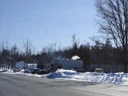
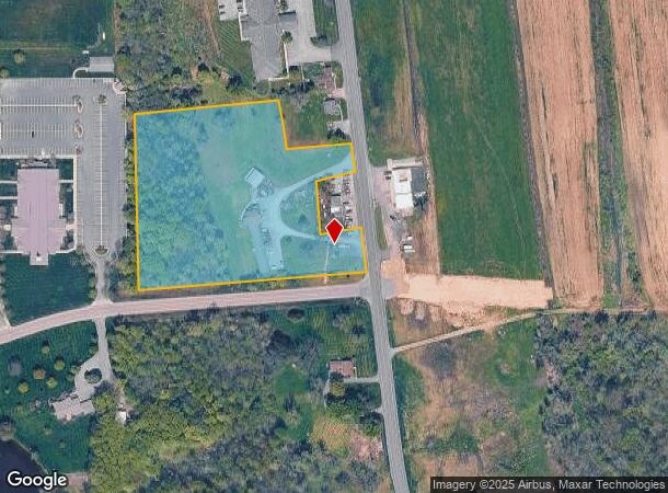
Property Record
885 Canandaigua Rd, Palmyra, NY 14522
NEARBY LISTINGS FOR SALE OR LEASE
Property Detail
885 Canandaigua Rd
Rochester, NY
ROOMING HOUSE + APT 32110-00-599933
543689-064-110-0000-628-932-0000
Wayne
Apartment
New York
2025
628.932
2024
5.20 AC
020700
Wayne County
5,569 SF
Rochester
DEMOGRAPHICS near 885 Canandaigua Rd
1 Mile
3 Mile
5 Mile
2024 Total Population
925
7,386
14,908
2029 Population
930
7,379
14,830
Pop Growth 2024-2029
+ 0.54%
(0.09%)
(0.52%)
Average Age
42
43
43
2024 Total Households
391
3,166
6,346
HH Growth 2024-2029
+ 0.26%
(0.16%)
(0.60%)
Median Household Inc
$71,086
$73,499
$72,218
Avg Household Size
2.40
2.30
2.30
2024 Avg HH Vehicles
2.00
2.00
2.00
Median Home Value
$149,152
$157,355
$153,965
Median Year Built
1952
1958
1967
Nearby Places
- Restaurants
- Banks
- Shops
- Fitness
- Groceries
PUBLIC TRANSPORTATION
AIRPORT
Frederick Douglass/Greater Rochester International
DRIVE
WALK
Distance
Frederick Douglass/Greater Rochester International
41 min
26.2 mi
Freight Ports
Albany, NY Port
DRIVE
WALK
Distance
Albany, NY Port
242 min
205.6 mi
Nearby Properties
Address
Land Use
TOTAL SIZE
Lot Size
Zoning
Address
Land Use
TOTAL SIZE
Lot Size
Zoning
Address
Land Use
TOTAL SIZE
Lot Size
Zoning
13,806 SF
137.28 AC
LI
Address
Land Use
TOTAL SIZE
Lot Size
Zoning
126,403 SF
5.86 AC
R1
Address
Land Use
TOTAL SIZE
Lot Size
Zoning
110,254 SF
16.08 AC
R1
Address
Land Use
TOTAL SIZE
Lot Size
Zoning
4.60 AC
02 - SINGL
Address
Land Use
TOTAL SIZE
Lot Size
Zoning
6,000 SF
15 AC
Address
Land Use
TOTAL SIZE
Lot Size
Zoning
39.40 AC
Address
Land Use
TOTAL SIZE
Lot Size
Zoning
24,484 SF
13.69 AC
R1
Address
Land Use
TOTAL SIZE
Lot Size
Zoning
61,044 SF
3.33 AC
R2
Address
Land Use
TOTAL SIZE
Lot Size
Zoning
10,904 SF
1 AC
C3
Address
Land Use
TOTAL SIZE
Lot Size
Zoning
1,208 SF
3.34 AC
R2-PD
Address
Land Use
TOTAL SIZE
Lot Size
Zoning
6,080 SF
16.15 AC
R1
Address
Land Use
TOTAL SIZE
Lot Size
Zoning
9,298 SF
14.80 AC
R2
Address
Land Use
TOTAL SIZE
Lot Size
Zoning
Address
Land Use
TOTAL SIZE
Lot Size
Zoning
65,195 SF
1.27 AC
C1
Address
Land Use
TOTAL SIZE
Lot Size
Zoning
11,600 SF
39.67 AC
Address
Land Use
TOTAL SIZE
Lot Size
Zoning
4,232 SF
3.14 AC
C3
Address
Land Use
TOTAL SIZE
Lot Size
Zoning
0.01 AC
Address
Land Use
TOTAL SIZE
Lot Size
Zoning
Address
Land Use
TOTAL SIZE
Lot Size
Zoning
12,528 SF
1.75 AC
C1
Address
Land Use
TOTAL SIZE
Lot Size
Zoning
5,400 SF
155.32 AC
Address
Land Use
TOTAL SIZE
Lot Size
Zoning
15,400 SF
30.16 AC
R1
Address
Land Use
TOTAL SIZE
Lot Size
Zoning
37,560 SF
24.50 AC
04 - FARM
Address
Land Use
TOTAL SIZE
Lot Size
Zoning
8,560 SF
1.21 AC
R2
Address
Land Use
TOTAL SIZE
Lot Size
Zoning
5,049 SF
1.57 AC
R1
Address
Land Use
TOTAL SIZE
Lot Size
Zoning
23,880 SF
3.13 AC
R1
Address
Land Use
TOTAL SIZE
Lot Size
Zoning
52,800 SF
4.20 AC
LI
Address
Land Use
TOTAL SIZE
Lot Size
Zoning
1,066 SF
35.79 AC
R1
Address
Land Use
TOTAL SIZE
Lot Size
Zoning
980 SF
29.58 AC
AR
Address
Land Use
TOTAL SIZE
Lot Size
Zoning
7,520 SF
7.30 AC
R1
The World's #1 Commercial Real Estate Marketplace
Connect with us
© 2025 CoStar Group
The information above has been obtained from sources believed reliable. While we do not doubt its accuracy we have not verified it and make no guarantee, warranty or representation about it. It is your responsibility to independently confirm its accuracy and completeness. Any projections, opinions, assumptions, or estimates used are for example only and do not represent the current or future performance of the property. The value of this transaction to you depends on tax and other factors which should be evaluated by your tax, financial, and legal advisors. You and your advisors should conduct a careful, independent investigation of the property to determine to your satisfaction the suitability of the property for your needs.