Property Record
885 Marrows Rd, Newark, DE 19713
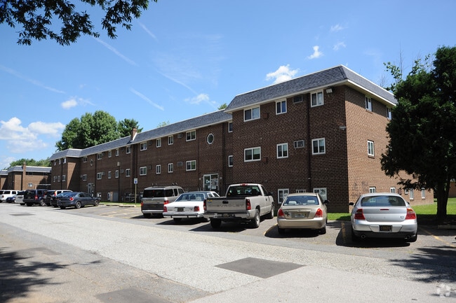

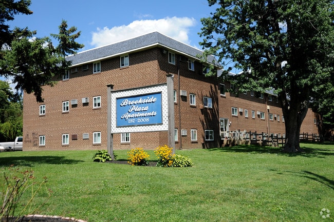
Property Detail
885 Marrows Rd
11-002.40-121
BEG AT POINT ON NLY SIDE OF BROOKSIDE BLVD AT 60 FT WIDE
Apartment
New Castle
NCAP
Delaware
AE The base floodplain where base flood elevations are provided. AE Zones are now used on new format FIRMs instead of A1-A30 Zones.
a,b
2024
3.10 AC
2024
Upper New Castle County
014703
Philadelphia
36,586 SF
Philadelphia-Camden-Wilmington, PA-NJ-DE-MD
NEARBY LISTINGS FOR SALE OR LEASE
DEMOGRAPHICS near 885 Marrows Rd
1 mile
3 mile
5 mile
2025 Total Population
12,390
90,253
188,727
2030 Population
12,739
94,341
195,656
Pop Growth 2025-2030
+ 2.82%
+ 4.53%
+ 3.67%
Average Age
39
37
39
2025 Total Households
4,692
32,458
72,179
HH Growth 2025-2030
+ 3.15%
+ 4.79%
+ 3.82%
Median Household Inc
$66,866
$77,886
$82,557
Avg Household Size
2.50
2.50
2.50
2025 Avg HH Vehicles
2.00
2.00
2.00
Median Home Value
$260,489
$333,298
$329,181
Median Year Built
1969
1977
1983
Nearby Places
Map Layers
Map Styles
 Street
 Aerial
Transit
 Traffic
 Biking
Places
Listings with unknown addresses are not visible on the map
- Restaurants
- Banks
- Shops
- Fitness
- Groceries
PUBLIC TRANSPORTATION
COMMUTER RAIL
Newark (R2 - Southeastern Pennsylvania Transportation Authority Regional Rail (SEPTA Regional Rail))
Drive
Walk
Distance
Newark (R2 - Southeastern Pennsylvania Transportation Authority Regional Rail (SEPTA Regional Rail))
3 min
2.5 mi
Churchmans Crossing (R2 - Southeastern Pennsylvania Transportation Authority Regional Rail (SEPTA Regional Rail))
Drive
Walk
Distance
Churchmans Crossing (R2 - Southeastern Pennsylvania Transportation Authority Regional Rail (SEPTA Regional Rail))
7 min
4.3 mi
AIRPORT
Philadelphia International
Drive
Walk
Distance
Philadelphia International
45 min
33.2 mi
Freight Ports
Port of Wilmington, RI
Drive
Walk
Distance
Port of Wilmington, RI
20 min
13.2 mi
Nearby Properties
Address
Land Use
TOTAL SIZE
Lot Size
Zoning
Address
Land Use
TOTAL SIZE
Lot Size
Zoning
354.61 AC
18UN
Address
Land Use
TOTAL SIZE
Lot Size
Zoning
108,170 SF
111.08 AC
18UN
Address
Land Use
TOTAL SIZE
Lot Size
Zoning
186,700 SF
5.50 AC
18UN
Address
Land Use
TOTAL SIZE
Lot Size
Zoning
119,820 SF
19.86 AC
18UN
Address
Land Use
TOTAL SIZE
Lot Size
Zoning
Address
Land Use
TOTAL SIZE
Lot Size
Zoning
62,498 SF
132.23 AC
I
Address
Land Use
TOTAL SIZE
Lot Size
Zoning
33,790 SF
45.17 AC
S
Address
Land Use
TOTAL SIZE
Lot Size
Zoning
Address
Land Use
TOTAL SIZE
Lot Size
Zoning
Address
Land Use
TOTAL SIZE
Lot Size
Zoning
92,081 SF
30.99 AC
18RM
Address
Land Use
TOTAL SIZE
Lot Size
Zoning
4,520 SF
3.51 AC
18UN
Address
Land Use
TOTAL SIZE
Lot Size
Zoning
Address
Land Use
TOTAL SIZE
Lot Size
Zoning
138,791 SF
15.19 AC
18STC
Address
Land Use
TOTAL SIZE
Lot Size
Zoning
Address
Land Use
TOTAL SIZE
Lot Size
Zoning
930 SF
52.69 AC
S
Address
Land Use
TOTAL SIZE
Lot Size
Zoning
247,122 SF
30.25 AC
S
Address
Land Use
TOTAL SIZE
Lot Size
Zoning
3,150 SF
11.90 AC
NC6.5
Address
Land Use
TOTAL SIZE
Lot Size
Zoning
43,943 SF
8.95 AC
18BB
Address
Land Use
TOTAL SIZE
Lot Size
Zoning
4.57 AC
18UN
Address
Land Use
TOTAL SIZE
Lot Size
Zoning
Address
Land Use
TOTAL SIZE
Lot Size
Zoning
80,834 SF
4.60 AC
18BB
Address
Land Use
TOTAL SIZE
Lot Size
Zoning
Address
Land Use
TOTAL SIZE
Lot Size
Zoning
7,146 SF
20 AC
S
Address
Land Use
TOTAL SIZE
Lot Size
Zoning
2,400 SF
9.18 AC
18UN
Address
Land Use
TOTAL SIZE
Lot Size
Zoning
54,907 SF
21.74 AC
18RA
Address
Land Use
TOTAL SIZE
Lot Size
Zoning
2,463 SF
5.98 AC
18STC
Address
Land Use
TOTAL SIZE
Lot Size
Zoning
117,727 SF
19.17 AC
NCAP
Address
Land Use
TOTAL SIZE
Lot Size
Zoning
385,350 SF
43.51 AC
OR
Address
Land Use
TOTAL SIZE
Lot Size
Zoning
150,729 SF
1.60 AC
CR
Address
Land Use
TOTAL SIZE
Lot Size
Zoning
351,528 SF
24.88 AC
NCAP
The World's #1 Commercial Real Estate Marketplace
Connect with us
© 2026 CoStar Group
The information above has been obtained from sources believed reliable. While we do not doubt its accuracy we have not verified it and make no guarantee, warranty or representation about it. It is your responsibility to independently confirm its accuracy and completeness. Any projections, opinions, assumptions, or estimates used are for example only and do not represent the current or future performance of the property. The value of this transaction to you depends on tax and other factors which should be evaluated by your tax, financial, and legal advisors. You and your advisors should conduct a careful, independent investigation of the property to determine to your satisfaction the suitability of the property for your needs.