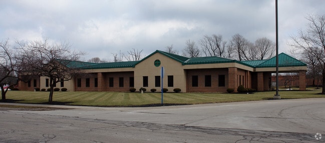
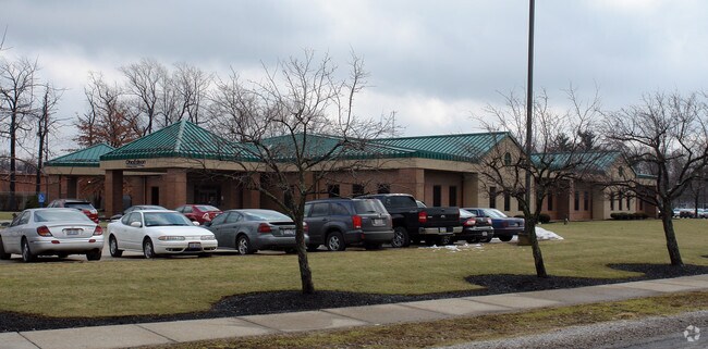
Property Record
885 Mull Ave, Akron, OH 44313

Property Detail
885 Mull Ave
Akron, OH
WPP LOTS 8 & 9 & PT VAC ST AKRON SERVICE CENTER
68-61633
SUMMIT
Commercialnec
Ohio
AE The base floodplain where base flood elevations are provided. AE Zones are now used on new format FIRMs instead of A1-A30 Zones.
8,9
2023
116.80 AC
2025
Akron
507201
Cleveland
327,798 SF
NEARBY LISTINGS FOR SALE OR LEASE
DEMOGRAPHICS near 885 Mull Ave
1 mile
3 mile
5 mile
2025 Total Population
9,231
66,778
158,693
2030 Population
9,153
66,810
159,042
Pop Growth 2025-2030
(0.84%)
+ 0.05%
+ 0.22%
Average Age
42
43
41
2025 Total Households
4,464
31,018
68,972
HH Growth 2025-2030
(0.83%)
+ 0.06%
+ 0.20%
Median Household Inc
$73,918
$64,605
$58,278
Avg Household Size
2.00
2.10
2.20
2025 Avg HH Vehicles
2.00
2.00
2.00
Median Home Value
$189,314
$197,771
$182,672
Median Year Built
1954
1957
1957
Nearby Places
Map Layers
Map Styles
 Street
 Aerial
Layers
 Traffic
 Biking
Places
Listings with unknown addresses are not visible on the map
- Restaurants
- Banks
- Shops
- Fitness
- Groceries
PUBLIC TRANSPORTATION
COMMUTER RAIL
Akron Northside (National Park Scenic Railway - Cuyahoga Valley Scenic Railroad)
Drive
Walk
Distance
Akron Northside (National Park Scenic Railway - Cuyahoga Valley Scenic Railroad)
12 min
4.4 mi
Big Bend (National Park Scenic Railway - Cuyahoga Valley Scenic Railroad)
Drive
Walk
Distance
Big Bend (National Park Scenic Railway - Cuyahoga Valley Scenic Railroad)
12 min
4.6 mi
AIRPORT
Akron-Canton Regional
Drive
Walk
Distance
Akron-Canton Regional
29 min
19.0 mi
Cleveland-Hopkins International
Drive
Walk
Distance
Cleveland-Hopkins International
53 min
36.1 mi
Freight Ports
Port of Toledo
Drive
Walk
Distance
Port of Toledo
156 min
129.0 mi
Nearby Properties
Address
Land Use
TOTAL SIZE
Lot Size
Zoning
Address
Land Use
TOTAL SIZE
Lot Size
Zoning
Address
Land Use
TOTAL SIZE
Lot Size
Zoning
282,490 SF
20.76 AC
Address
Land Use
TOTAL SIZE
Lot Size
Zoning
676,403 SF
39.06 AC
Address
Land Use
TOTAL SIZE
Lot Size
Zoning
194,508 SF
30.87 AC
Address
Land Use
TOTAL SIZE
Lot Size
Zoning
91,104 SF
17.30 AC
Address
Land Use
TOTAL SIZE
Lot Size
Zoning
311,093 SF
32.53 AC
Address
Land Use
TOTAL SIZE
Lot Size
Zoning
479,446 SF
6.07 AC
Address
Land Use
TOTAL SIZE
Lot Size
Zoning
246,312 SF
17.50 AC
Address
Land Use
TOTAL SIZE
Lot Size
Zoning
231,968 SF
29.14 AC
Address
Land Use
TOTAL SIZE
Lot Size
Zoning
10 AC
Address
Land Use
TOTAL SIZE
Lot Size
Zoning
10.78 AC
Address
Land Use
TOTAL SIZE
Lot Size
Zoning
12.46 AC
Address
Land Use
TOTAL SIZE
Lot Size
Zoning
313,167 SF
18.50 AC
Address
Land Use
TOTAL SIZE
Lot Size
Zoning
43,574 SF
3.67 AC
Address
Land Use
TOTAL SIZE
Lot Size
Zoning
76,560 SF
6.07 AC
Address
Land Use
TOTAL SIZE
Lot Size
Zoning
10.26 AC
Address
Land Use
TOTAL SIZE
Lot Size
Zoning
113,059 SF
7.46 AC
Address
Land Use
TOTAL SIZE
Lot Size
Zoning
123,800 SF
76.50 AC
Address
Land Use
TOTAL SIZE
Lot Size
Zoning
54,398 SF
8.10 AC
Address
Land Use
TOTAL SIZE
Lot Size
Zoning
58,639 SF
2.29 AC
Address
Land Use
TOTAL SIZE
Lot Size
Zoning
Address
Land Use
TOTAL SIZE
Lot Size
Zoning
Address
Land Use
TOTAL SIZE
Lot Size
Zoning
209,183 SF
36.34 AC
Address
Land Use
TOTAL SIZE
Lot Size
Zoning
123,367 SF
8.81 AC
Address
Land Use
TOTAL SIZE
Lot Size
Zoning
105,770 SF
16.40 AC
Address
Land Use
TOTAL SIZE
Lot Size
Zoning
136,381 SF
6.51 AC
Address
Land Use
TOTAL SIZE
Lot Size
Zoning
104,861 SF
2.07 AC
Address
Land Use
TOTAL SIZE
Lot Size
Zoning
63,298 SF
3.99 AC
Address
Land Use
TOTAL SIZE
Lot Size
Zoning
63,918 SF
4.95 AC
The World's #1 Commercial Real Estate Marketplace
Connect with us
© 2026 CoStar Group
The information above has been obtained from sources believed reliable. While we do not doubt its accuracy we have not verified it and make no guarantee, warranty or representation about it. It is your responsibility to independently confirm its accuracy and completeness. Any projections, opinions, assumptions, or estimates used are for example only and do not represent the current or future performance of the property. The value of this transaction to you depends on tax and other factors which should be evaluated by your tax, financial, and legal advisors. You and your advisors should conduct a careful, independent investigation of the property to determine to your satisfaction the suitability of the property for your needs.