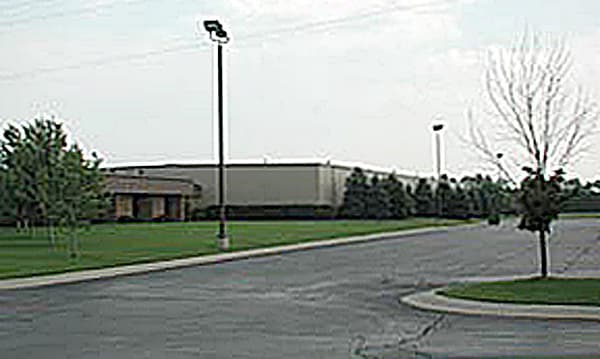
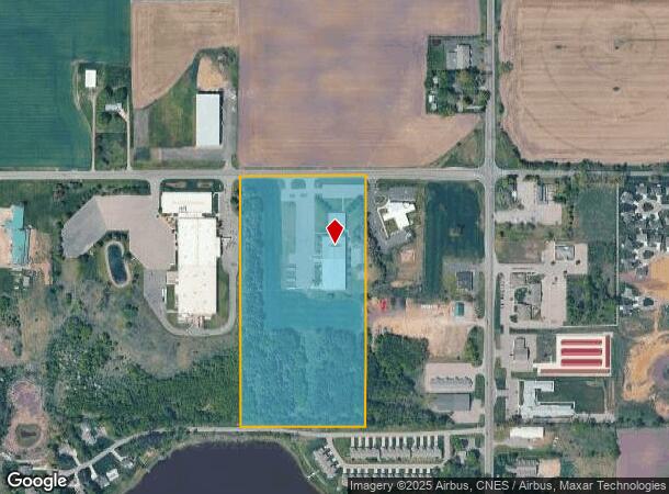
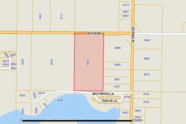
Property Record
8850 M 89, Richland, MI 49083
NEARBY LISTINGS FOR SALE OR LEASE
Property Detail
8850 M 89
03-15-230-011
SEC 15-1-10 W1/2 NE1/4 NE1/4
Industrialgeneral
Kalamazoo
X
Michigan
26077C0100E
20 AC
2025
NE Kalamazoo County
2025
West Michigan
002702
Kalamazoo-Portage, MI
42,006 SF
DEMOGRAPHICS near 8850 M 89
1 Mile
3 Mile
5 Mile
2024 Total Population
1,344
6,758
15,719
2029 Population
1,351
6,806
15,845
Pop Growth 2024-2029
+ 0.52%
+ 0.71%
+ 0.80%
Average Age
40
41
42
2024 Total Households
515
2,627
6,091
HH Growth 2024-2029
+ 0.39%
+ 0.72%
+ 0.85%
Median Household Inc
$92,021
$85,103
$88,601
Avg Household Size
2.60
2.60
2.60
2024 Avg HH Vehicles
2.00
2.00
2.00
Median Home Value
$244,834
$259,492
$267,871
Median Year Built
1987
1983
1982
Nearby Places
Map Layers
Map Styles
 Street
 Aerial
- Restaurants
- Banks
- Shops
- Fitness
- Groceries
PUBLIC TRANSPORTATION
AIRPORT
Kalamazoo/Battle Creek International
DRIVE
WALK
Distance
Kalamazoo/Battle Creek International
28 min
13.6 mi
Freight Ports
Port of Toledo
DRIVE
WALK
Distance
Port of Toledo
170 min
139.4 mi
SALE & LEASE HISTORY
LISTING DATE
SALE/LEASE

Sep 25, 2016
For Lease
Sep 24, 2016
For Sale
Nearby Properties
Address
Land Use
TOTAL SIZE
Lot Size
Zoning
Address
Land Use
TOTAL SIZE
Lot Size
Zoning
163.30 AC
A
Address
Land Use
TOTAL SIZE
Lot Size
Zoning
135,080 SF
30 AC
D
Address
Land Use
TOTAL SIZE
Lot Size
Zoning
37,027 SF
133.10 AC
R/OS
Address
Land Use
TOTAL SIZE
Lot Size
Zoning
1,757 SF
509.49 AC
A-1
Address
Land Use
TOTAL SIZE
Lot Size
Zoning
17,662 SF
3.72 AC
D
Address
Land Use
TOTAL SIZE
Lot Size
Zoning
183.43 AC
A-1
Address
Land Use
TOTAL SIZE
Lot Size
Zoning
0.94 AC
R-1
Address
Land Use
TOTAL SIZE
Lot Size
Zoning
38.66 AC
A-1
Address
Land Use
TOTAL SIZE
Lot Size
Zoning
1.15 AC
R-1
Address
Land Use
TOTAL SIZE
Lot Size
Zoning
26,398 SF
5.75 AC
Address
Land Use
TOTAL SIZE
Lot Size
Zoning
26,576 SF
13.80 AC
B-1
Address
Land Use
TOTAL SIZE
Lot Size
Zoning
1,435 SF
326.34 AC
A-1
Address
Land Use
TOTAL SIZE
Lot Size
Zoning
18,588 SF
7.67 AC
D
Address
Land Use
TOTAL SIZE
Lot Size
Zoning
277.46 AC
AB
Address
Land Use
TOTAL SIZE
Lot Size
Zoning
1.95 AC
D
Address
Land Use
TOTAL SIZE
Lot Size
Zoning
3.61 AC
P1
Address
Land Use
TOTAL SIZE
Lot Size
Zoning
54,576 SF
6.06 AC
D-1
Address
Land Use
TOTAL SIZE
Lot Size
Zoning
61,620 SF
7.39 AC
D
Address
Land Use
TOTAL SIZE
Lot Size
Zoning
29,280 SF
6.40 AC
B-1
Address
Land Use
TOTAL SIZE
Lot Size
Zoning
21,560 SF
3.37 AC
D
Address
Land Use
TOTAL SIZE
Lot Size
Zoning
7,200 SF
1.48 AC
D-1
Address
Land Use
TOTAL SIZE
Lot Size
Zoning
1,350 SF
188.63 AC
A-1
Address
Land Use
TOTAL SIZE
Lot Size
Zoning
Address
Land Use
TOTAL SIZE
Lot Size
Zoning
31,380 SF
5 AC
D
Address
Land Use
TOTAL SIZE
Lot Size
Zoning
Address
Land Use
TOTAL SIZE
Lot Size
Zoning
2,436 SF
80 AC
A-1
Address
Land Use
TOTAL SIZE
Lot Size
Zoning
19,296 SF
3.10 AC
B-1
Address
Land Use
TOTAL SIZE
Lot Size
Zoning
19,296 SF
3.10 AC
B-1
Address
Land Use
TOTAL SIZE
Lot Size
Zoning
1,120 SF
45.62 AC
C-2
The World's #1 Commercial Real Estate Marketplace
Connect with us
© 2025 CoStar Group
The information above has been obtained from sources believed reliable. While we do not doubt its accuracy we have not verified it and make no guarantee, warranty or representation about it. It is your responsibility to independently confirm its accuracy and completeness. Any projections, opinions, assumptions, or estimates used are for example only and do not represent the current or future performance of the property. The value of this transaction to you depends on tax and other factors which should be evaluated by your tax, financial, and legal advisors. You and your advisors should conduct a careful, independent investigation of the property to determine to your satisfaction the suitability of the property for your needs.