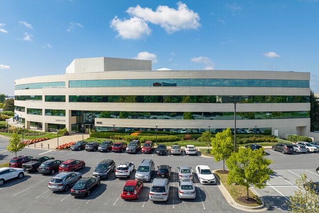
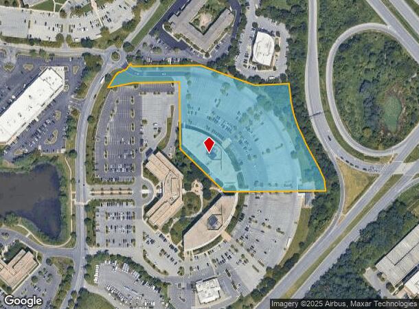
Property Record
8850 Stanford Blvd, Columbia, MD 21045

Current Lease Availabilities
NEARBY LISTINGS FOR SALE OR LEASE
Property Detail
8850 Stanford Blvd
Baltimore-Columbia-Towson, MD
Seiling Indust Center Sec 01
16-191140
PAR A 3 6.564 A 8850 STANFORD BLVD REAR SEILING IND CT S 1 AR 1
Officebuilding
Howard
X
Maryland
24027C0155D
a 3
2024
6.56 AC
2025
Columbia South
606708
Baltimore
103,203 SF
DEMOGRAPHICS near 8850 Stanford Blvd
1 Mile
3 Mile
5 Mile
2024 Total Population
6,120
92,747
212,620
2029 Population
6,243
95,327
218,561
Pop Growth 2024-2029
+ 2.01%
+ 2.78%
+ 2.79%
Average Age
43
38
39
2024 Total Households
2,431
34,423
79,683
HH Growth 2024-2029
+ 2.02%
+ 2.84%
+ 2.84%
Median Household Inc
$128,125
$121,274
$123,548
Avg Household Size
2.50
2.60
2.60
2024 Avg HH Vehicles
2.00
2.00
2.00
Median Home Value
$446,931
$406,167
$450,021
Median Year Built
1992
1986
1987
Nearby Places
- Restaurants
- Banks
- Shops
- Fitness
- Groceries
PUBLIC TRANSPORTATION
COMMUTER RAIL
Jessup (Camden Line - Maryland Area Regional Commuter Trains (The MARC))
DRIVE
WALK
Distance
Jessup (Camden Line - Maryland Area Regional Commuter Trains (The MARC))
11 min
5.3 mi
DRIVE
WALK
Distance
13 min
6.4 mi
AIRPORT
Baltimore/Washington International Thurgood Marshall
DRIVE
WALK
Distance
Baltimore/Washington International Thurgood Marshall
22 min
13.9 mi
Ronald Reagan Washington Ntl
DRIVE
WALK
Distance
Ronald Reagan Washington Ntl
54 min
33.2 mi
Freight Ports
Port of Baltimore
DRIVE
WALK
Distance
Port of Baltimore
25 min
16.5 mi
Nearby Properties
Address
Land Use
TOTAL SIZE
Lot Size
Zoning
Address
Land Use
TOTAL SIZE
Lot Size
Zoning
454,000 SF
62.33 AC
NT
Address
Land Use
TOTAL SIZE
Lot Size
Zoning
1,007,900 SF
88.77 AC
M2
Address
Land Use
TOTAL SIZE
Lot Size
Zoning
853,520 SF
47.33 AC
M2
Address
Land Use
TOTAL SIZE
Lot Size
Zoning
31,730 SF
43.99 AC
RA15
Address
Land Use
TOTAL SIZE
Lot Size
Zoning
47,815 SF
11.76 AC
NT
Address
Land Use
TOTAL SIZE
Lot Size
Zoning
172,360 SF
2.79 AC
NT
Address
Land Use
TOTAL SIZE
Lot Size
Zoning
514,261 SF
3.36 AC
NT
Address
Land Use
TOTAL SIZE
Lot Size
Zoning
218,688 SF
1.11 AC
NT
Address
Land Use
TOTAL SIZE
Lot Size
Zoning
154,666 SF
27.65 AC
M1
Address
Land Use
TOTAL SIZE
Lot Size
Zoning
77,028 SF
18.68 AC
NT
Address
Land Use
TOTAL SIZE
Lot Size
Zoning
87,344 SF
5.46 AC
CECLI
Address
Land Use
TOTAL SIZE
Lot Size
Zoning
307,626 SF
5.46 AC
CACLI
Address
Land Use
TOTAL SIZE
Lot Size
Zoning
357,008 SF
1.57 AC
NT
Address
Land Use
TOTAL SIZE
Lot Size
Zoning
988,378 SF
115.55 AC
M1
Address
Land Use
TOTAL SIZE
Lot Size
Zoning
256,156 SF
14.56 AC
M1
Address
Land Use
TOTAL SIZE
Lot Size
Zoning
309,703 SF
39.71 AC
R20
Address
Land Use
TOTAL SIZE
Lot Size
Zoning
370,240 SF
4.18 AC
CACLI
Address
Land Use
TOTAL SIZE
Lot Size
Zoning
55,400 SF
10.19 AC
CACLI
Address
Land Use
TOTAL SIZE
Lot Size
Zoning
56,584 SF
12.03 AC
RA15
Address
Land Use
TOTAL SIZE
Lot Size
Zoning
195,996 SF
48.91 AC
NT
Address
Land Use
TOTAL SIZE
Lot Size
Zoning
191,036 SF
4.25 AC
2R0
Address
Land Use
TOTAL SIZE
Lot Size
Zoning
236,935 SF
37.08 AC
M1
Address
Land Use
TOTAL SIZE
Lot Size
Zoning
21.07 AC
MXD-E
Address
Land Use
TOTAL SIZE
Lot Size
Zoning
214,009 SF
8.99 AC
NT
Address
Land Use
TOTAL SIZE
Lot Size
Zoning
242,910 SF
32.60 AC
NT
Address
Land Use
TOTAL SIZE
Lot Size
Zoning
133,600 SF
11.75 AC
NT
Address
Land Use
TOTAL SIZE
Lot Size
Zoning
234,007 SF
49.96 AC
NT
Address
Land Use
TOTAL SIZE
Lot Size
Zoning
208,800 SF
6.58 AC
CACLI
Address
Land Use
TOTAL SIZE
Lot Size
Zoning
151,844 SF
5.77 AC
CACLI
Address
Land Use
TOTAL SIZE
Lot Size
Zoning
157,672 SF
14.16 AC
B2
The World's #1 Commercial Real Estate Marketplace
Connect with us
© 2025 CoStar Group
The information above has been obtained from sources believed reliable. While we do not doubt its accuracy we have not verified it and make no guarantee, warranty or representation about it. It is your responsibility to independently confirm its accuracy and completeness. Any projections, opinions, assumptions, or estimates used are for example only and do not represent the current or future performance of the property. The value of this transaction to you depends on tax and other factors which should be evaluated by your tax, financial, and legal advisors. You and your advisors should conduct a careful, independent investigation of the property to determine to your satisfaction the suitability of the property for your needs.