Property Record
8851 Ellstree Ln, Raleigh, NC 27617
Current Lease Availabilities
NEARBY LISTINGS FOR SALE OR LEASE
Property Detail
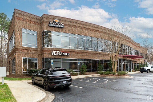
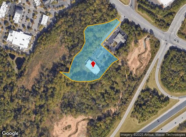
8851 Ellstree Ln
Raleigh-Cary, NC
Brier Creek Parcel H-8 Sub
0768.03-22-2237-000
LO2 BRIER CREEK PARCEL H-8 SUB BM2005-15
Medicalbuilding
Wake
AE
North Carolina
3720076800K
2
2025
4.54 AC
2025
RTP/RDU
053615
Raleigh/Durham
25,012 SF
DEMOGRAPHICS near 8851 Ellstree Ln
1 Mile
3 Mile
5 Mile
2024 Total Population
7,351
37,652
98,077
2029 Population
7,973
40,538
105,597
Pop Growth 2024-2029
+ 8.46%
+ 7.66%
+ 7.67%
Average Age
37
40
39
2024 Total Households
3,797
17,958
43,462
HH Growth 2024-2029
+ 8.45%
+ 7.71%
+ 7.82%
Median Household Inc
$97,070
$96,146
$104,728
Avg Household Size
1.90
2.10
2.20
2024 Avg HH Vehicles
2.00
2.00
2.00
Median Home Value
$453,086
$401,051
$386,008
Median Year Built
2004
2008
2006
Nearby Places
Map Layers
Map Styles
 Street
 Aerial
- Restaurants
- Banks
- Shops
- Fitness
- Groceries
PUBLIC TRANSPORTATION
AIRPORT
Raleigh-Durham International
DRIVE
WALK
Distance
Raleigh-Durham International
7 min
3.3 mi
Nearby Properties
Address
Land Use
TOTAL SIZE
Lot Size
Zoning
Address
Land Use
TOTAL SIZE
Lot Size
Zoning
3,672,648 SF
4,584.26 AC
AD-2
Address
Land Use
TOTAL SIZE
Lot Size
Zoning
24,907 SF
5,245.45 AC
R-4
Address
Land Use
TOTAL SIZE
Lot Size
Zoning
8,418 SF
22.17 AC
MU(D)
Address
Land Use
TOTAL SIZE
Lot Size
Zoning
11,670 SF
41.27 AC
RS-M(D)
Address
Land Use
TOTAL SIZE
Lot Size
Zoning
15,252 SF
29.36 AC
RS-M
Address
Land Use
TOTAL SIZE
Lot Size
Zoning
543,777 SF
28.13 AC
RX-4
Address
Land Use
TOTAL SIZE
Lot Size
Zoning
385,640 SF
36.45 AC
RX-4
Address
Land Use
TOTAL SIZE
Lot Size
Zoning
441,283 SF
23.76 AC
PD
Address
Land Use
TOTAL SIZE
Lot Size
Zoning
529,439 SF
29.84 AC
IL
Address
Land Use
TOTAL SIZE
Lot Size
Zoning
431,534 SF
23.20 AC
RX-4
Address
Land Use
TOTAL SIZE
Lot Size
Zoning
370,540 SF
20.79 AC
PD
Address
Land Use
TOTAL SIZE
Lot Size
Zoning
287,656 SF
20.62 AC
PDR-H
Address
Land Use
TOTAL SIZE
Lot Size
Zoning
21.83 AC
OI
Address
Land Use
TOTAL SIZE
Lot Size
Zoning
303,191 SF
19.18 AC
PD
Address
Land Use
TOTAL SIZE
Lot Size
Zoning
407,178 SF
22.57 AC
PD
Address
Land Use
TOTAL SIZE
Lot Size
Zoning
262,391 SF
8 AC
PD
Address
Land Use
TOTAL SIZE
Lot Size
Zoning
278,044 SF
17.79 AC
RX-3
Address
Land Use
TOTAL SIZE
Lot Size
Zoning
267,757 SF
35.89 AC
CX-5
Address
Land Use
TOTAL SIZE
Lot Size
Zoning
456,072 SF
35.73 AC
IP
Address
Land Use
TOTAL SIZE
Lot Size
Zoning
303,290 SF
14.48 AC
RX-3
Address
Land Use
TOTAL SIZE
Lot Size
Zoning
386,506 SF
55.21 AC
IH
Address
Land Use
TOTAL SIZE
Lot Size
Zoning
24,012 SF
19.61 AC
RS-M(D)
Address
Land Use
TOTAL SIZE
Lot Size
Zoning
12,468 SF
20.97 AC
MU(D)
Address
Land Use
TOTAL SIZE
Lot Size
Zoning
4,850 SF
14.59 AC
PDR 4.733
Address
Land Use
TOTAL SIZE
Lot Size
Zoning
296,141 SF
14.38 AC
PD
Address
Land Use
TOTAL SIZE
Lot Size
Zoning
451,553 SF
422.05 AC
IL
Address
Land Use
TOTAL SIZE
Lot Size
Zoning
318,216 SF
6.36 AC
OX-7
Address
Land Use
TOTAL SIZE
Lot Size
Zoning
281,616 SF
18.69 AC
PD
Address
Land Use
TOTAL SIZE
Lot Size
Zoning
459,640 SF
10.31 AC
MU(D)
Address
Land Use
TOTAL SIZE
Lot Size
Zoning
197,578 SF
9.33 AC
CX-5
The World's #1 Commercial Real Estate Marketplace
Connect with us
© 2026 CoStar Group
The information above has been obtained from sources believed reliable. While we do not doubt its accuracy we have not verified it and make no guarantee, warranty or representation about it. It is your responsibility to independently confirm its accuracy and completeness. Any projections, opinions, assumptions, or estimates used are for example only and do not represent the current or future performance of the property. The value of this transaction to you depends on tax and other factors which should be evaluated by your tax, financial, and legal advisors. You and your advisors should conduct a careful, independent investigation of the property to determine to your satisfaction the suitability of the property for your needs.