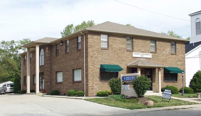
Property Record
8857 Cincinnati Dayton Rd, West Chester, OH 45069

NEARBY LISTINGS FOR SALE OR LEASE
Property Detail
8857 Cincinnati Dayton Rd
Cincinnati, OH-KY-IN
Village/West Chester
M5670-036-000-020
9 N 64 FT SEE TIF PCL 020T - CINTI DAYTON RD TIF
Officebuilding
Butler
X
Ohio
39017C0333F
9
2024
0.31 AC
2025
Butler County
011109
Cincinnati/Dayton
8,232 SF
DEMOGRAPHICS near 8857 Cincinnati Dayton Rd
1 Mile
3 Mile
5 Mile
2024 Total Population
3,989
52,545
135,622
2029 Population
4,032
53,157
139,087
Pop Growth 2024-2029
+ 1.08%
+ 1.16%
+ 2.55%
Average Age
39
40
40
2024 Total Households
1,513
19,765
50,427
HH Growth 2024-2029
+ 0.99%
+ 1.08%
+ 2.46%
Median Household Inc
$102,461
$102,455
$104,121
Avg Household Size
2.60
2.60
2.60
2024 Avg HH Vehicles
2.00
2.00
2.00
Median Home Value
$318,061
$270,883
$279,450
Median Year Built
1988
1986
1990
Nearby Places
Map Layers
Map Styles
 Street
 Aerial
- Restaurants
- Banks
- Shops
- Fitness
- Groceries
PUBLIC TRANSPORTATION
AIRPORT
Cincinnati/Northern Kentucky International
DRIVE
WALK
Distance
Cincinnati/Northern Kentucky International
53 min
33.7 mi
Freight Ports
Port of Toledo
DRIVE
WALK
Distance
Port of Toledo
216 min
186.3 mi
SALE & LEASE HISTORY
LISTING DATE
SALE/LEASE

Nov 22, 2016
For Lease
Nov 02, 2023
For Lease
Nearby Properties
Address
Land Use
TOTAL SIZE
Lot Size
Zoning
Address
Land Use
TOTAL SIZE
Lot Size
Zoning
21,549 SF
30.60 AC
Address
Land Use
TOTAL SIZE
Lot Size
Zoning
10.76 AC
Address
Land Use
TOTAL SIZE
Lot Size
Zoning
11.19 AC
Address
Land Use
TOTAL SIZE
Lot Size
Zoning
987,717 SF
57.32 AC
Address
Land Use
TOTAL SIZE
Lot Size
Zoning
1,398,190 SF
54.91 AC
Address
Land Use
TOTAL SIZE
Lot Size
Zoning
136,681 SF
22.56 AC
Address
Land Use
TOTAL SIZE
Lot Size
Zoning
54,055 SF
18.17 AC
Address
Land Use
TOTAL SIZE
Lot Size
Zoning
300,943 SF
23.01 AC
Address
Land Use
TOTAL SIZE
Lot Size
Zoning
914,426 SF
41.39 AC
Address
Land Use
TOTAL SIZE
Lot Size
Zoning
782,765 SF
33.15 AC
Address
Land Use
TOTAL SIZE
Lot Size
Zoning
287,883 SF
10.90 AC
Address
Land Use
TOTAL SIZE
Lot Size
Zoning
4,620 SF
85.80 AC
Address
Land Use
TOTAL SIZE
Lot Size
Zoning
84,133 SF
4.28 AC
Address
Land Use
TOTAL SIZE
Lot Size
Zoning
176,055 SF
31.46 AC
Address
Land Use
TOTAL SIZE
Lot Size
Zoning
498,300 SF
14.86 AC
Address
Land Use
TOTAL SIZE
Lot Size
Zoning
342,284 SF
36.35 AC
Address
Land Use
TOTAL SIZE
Lot Size
Zoning
179,048 SF
12.32 AC
Address
Land Use
TOTAL SIZE
Lot Size
Zoning
105,280 SF
10.76 AC
Address
Land Use
TOTAL SIZE
Lot Size
Zoning
105,280 SF
11.19 AC
Address
Land Use
TOTAL SIZE
Lot Size
Zoning
Address
Land Use
TOTAL SIZE
Lot Size
Zoning
536,648 SF
22.28 AC
Address
Land Use
TOTAL SIZE
Lot Size
Zoning
434,916 SF
19.98 AC
Address
Land Use
TOTAL SIZE
Lot Size
Zoning
417,137 SF
47.57 AC
Address
Land Use
TOTAL SIZE
Lot Size
Zoning
433,277 SF
25.66 AC
Address
Land Use
TOTAL SIZE
Lot Size
Zoning
Address
Land Use
TOTAL SIZE
Lot Size
Zoning
54.92 AC
Address
Land Use
TOTAL SIZE
Lot Size
Zoning
433,309 SF
21.87 AC
Address
Land Use
TOTAL SIZE
Lot Size
Zoning
133,851 SF
17.47 AC
Address
Land Use
TOTAL SIZE
Lot Size
Zoning
158,680 SF
22.49 AC
Address
Land Use
TOTAL SIZE
Lot Size
Zoning
3,202 SF
3.34 AC
The World's #1 Commercial Real Estate Marketplace
Connect with us
© 2026 CoStar Group
The information above has been obtained from sources believed reliable. While we do not doubt its accuracy we have not verified it and make no guarantee, warranty or representation about it. It is your responsibility to independently confirm its accuracy and completeness. Any projections, opinions, assumptions, or estimates used are for example only and do not represent the current or future performance of the property. The value of this transaction to you depends on tax and other factors which should be evaluated by your tax, financial, and legal advisors. You and your advisors should conduct a careful, independent investigation of the property to determine to your satisfaction the suitability of the property for your needs.