Property Record
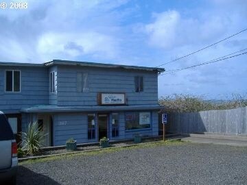
887 Highway 101 N, Yachats, OR 97498

Property Detail
887 Highway 101 N
Commercialnec
TWNSHP 14, RNG 12, ACRES 0.38, DOC201710488
C-1
Lincoln
B and X Area of moderate flood hazard, usually the area between the limits of the 100-year and 500-year floods.
Oregon
2025
0.38 AC
2025
Other Market Areas
951700
Newport, OR
3,682 SF
R235993
NEARBY LISTINGS FOR SALE OR LEASE
-
-
View all Yachats listings for sale on LoopNet.com
DEMOGRAPHICS near 887 Highway 101 N
1 mile
3 mile
5 mile
2024 Total Population
1,454
2,562
2,817
2029 Population
1,516
2,677
2,938
Pop Growth 2024-2029
+ 4.26%
+ 4.49%
+ 4.30%
Average Age
50
50
50
2024 Total Households
652
1,135
1,246
HH Growth 2024-2029
+ 3.68%
+ 3.88%
+ 3.69%
Median Household Inc
$75,312
$76,002
$76,111
Avg Household Size
1.90
1.90
1.90
2024 Avg HH Vehicles
2.00
2.00
2.00
Median Home Value
$619,198
$617,718
$604,072
Median Year Built
1978
1978
1978
Nearby Places
Map Layers
Map Styles
 Street
 Aerial
Transit
 Traffic
 Biking
Places
Listings with unknown addresses are not visible on the map
- Restaurants
- Banks
- Shops
- Fitness
- Groceries
Nearby Properties
Address
Land Use
TOTAL SIZE
Lot Size
Zoning
Address
Land Use
TOTAL SIZE
Lot Size
Zoning
50,252 SF
3.55 AC
R-4
Address
Land Use
TOTAL SIZE
Lot Size
Zoning
12,023 SF
1.60 AC
R-3
Address
Land Use
TOTAL SIZE
Lot Size
Zoning
4,780 SF
1.26 AC
PF
Address
Land Use
TOTAL SIZE
Lot Size
Zoning
23,583 SF
0.48 AC
R-3
Address
Land Use
TOTAL SIZE
Lot Size
Zoning
19,870 SF
3.47 AC
R-4
Address
Land Use
TOTAL SIZE
Lot Size
Zoning
1,800 SF
3,556.28 AC
T-C
Address
Land Use
TOTAL SIZE
Lot Size
Zoning
14,478 SF
3.04 AC
RR-2,DR
Address
Land Use
TOTAL SIZE
Lot Size
Zoning
0.92 AC
R-2
Address
Land Use
TOTAL SIZE
Lot Size
Zoning
28,902 SF
1.35 AC
R-3
Address
Land Use
TOTAL SIZE
Lot Size
Zoning
9,939 SF
0.65 AC
R-4
Address
Land Use
TOTAL SIZE
Lot Size
Zoning
14,604 SF
1.85 AC
PF
Address
Land Use
TOTAL SIZE
Lot Size
Zoning
28,902 SF
0.89 AC
R-3
Address
Land Use
TOTAL SIZE
Lot Size
Zoning
7,556 SF
0.55 AC
C-1
Address
Land Use
TOTAL SIZE
Lot Size
Zoning
6,400 SF
T-C
Address
Land Use
TOTAL SIZE
Lot Size
Zoning
5,154 SF
0.39 AC
C-1
Address
Land Use
TOTAL SIZE
Lot Size
Zoning
4,255 SF
0.23 AC
C-1
Address
Land Use
TOTAL SIZE
Lot Size
Zoning
8,722 SF
0.75 AC
C-1
Address
Land Use
TOTAL SIZE
Lot Size
Zoning
3,784 SF
6.16 AC
R-4
Address
Land Use
TOTAL SIZE
Lot Size
Zoning
3,312 SF
0.31 AC
C-1
Address
Land Use
TOTAL SIZE
Lot Size
Zoning
7,360 SF
0.25 AC
C-1
Address
Land Use
TOTAL SIZE
Lot Size
Zoning
2,656 SF
0.21 AC
C-1
Address
Land Use
TOTAL SIZE
Lot Size
Zoning
1,792 SF
0.11 AC
R-1
Address
Land Use
TOTAL SIZE
Lot Size
Zoning
4,235 SF
0.46 AC
C-1
Address
Land Use
TOTAL SIZE
Lot Size
Zoning
2,006 SF
0.15 AC
C-1
Address
Land Use
TOTAL SIZE
Lot Size
Zoning
0.83 AC
R-2
Address
Land Use
TOTAL SIZE
Lot Size
Zoning
2,864 SF
0.28 AC
C-1
Address
Land Use
TOTAL SIZE
Lot Size
Zoning
4,622 SF
1.99 AC
C-T
Address
Land Use
TOTAL SIZE
Lot Size
Zoning
27.91 AC
RR-2,DR
Address
Land Use
TOTAL SIZE
Lot Size
Zoning
2,350 SF
0.07 AC
R-3
The World's #1 Commercial Real Estate Marketplace
Connect with us
© 2026 CoStar Group
The information above has been obtained from sources believed reliable. While we do not doubt its accuracy we have not verified it and make no guarantee, warranty or representation about it. It is your responsibility to independently confirm its accuracy and completeness. Any projections, opinions, assumptions, or estimates used are for example only and do not represent the current or future performance of the property. The value of this transaction to you depends on tax and other factors which should be evaluated by your tax, financial, and legal advisors. You and your advisors should conduct a careful, independent investigation of the property to determine to your satisfaction the suitability of the property for your needs.