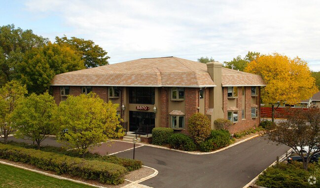
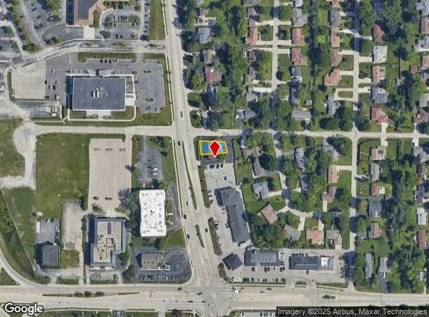
Property Record
8870 N Port Washington Rd, Milwaukee, WI 53217
NEARBY LISTINGS FOR SALE OR LEASE
Property Detail
8870 N Port Washington Rd
Milwaukee-Waukesha-West Allis, WI
Northway
022-0210-000
NORTHWAY LOT 1 BLK 10
Commercialnec
Milwaukee
X
Wisconsin
55089C0270G
1
0
0.12 AC
2024
North Shore
030100
Milwaukee/Madison
DEMOGRAPHICS near 8870 N Port Washington Rd
1 Mile
3 Mile
5 Mile
2024 Total Population
7,022
30,361
92,093
2029 Population
6,843
30,209
91,194
Pop Growth 2024-2029
(2.55%)
(0.50%)
(0.98%)
Average Age
44
45
42
2024 Total Households
2,904
12,722
38,142
HH Growth 2024-2029
(2.62%)
(0.59%)
(1.04%)
Median Household Inc
$121,078
$110,061
$77,555
Avg Household Size
2.40
2.30
2.40
2024 Avg HH Vehicles
2.00
2.00
2.00
Median Home Value
$370,680
$363,061
$299,910
Median Year Built
1962
1967
1964
Nearby Places
Map Layers
Map Styles
 Street
 Aerial
- Restaurants
- Banks
- Shops
- Fitness
- Groceries
PUBLIC TRANSPORTATION
AIRPORT
General Mitchell International
DRIVE
WALK
Distance
General Mitchell International
29 min
17.7 mi
Freight Ports
Port Milwaukee
DRIVE
WALK
Distance
Port Milwaukee
21 min
13.6 mi
Nearby Properties
Address
Land Use
TOTAL SIZE
Lot Size
Zoning
Address
Land Use
TOTAL SIZE
Lot Size
Zoning
Address
Land Use
TOTAL SIZE
Lot Size
Zoning
Address
Land Use
TOTAL SIZE
Lot Size
Zoning
Address
Land Use
TOTAL SIZE
Lot Size
Zoning
19.64 AC
Address
Land Use
TOTAL SIZE
Lot Size
Zoning
Address
Land Use
TOTAL SIZE
Lot Size
Zoning
Address
Land Use
TOTAL SIZE
Lot Size
Zoning
145,218 SF
10.23 AC
Address
Land Use
TOTAL SIZE
Lot Size
Zoning
72,824 SF
11.57 AC
Address
Land Use
TOTAL SIZE
Lot Size
Zoning
21.58 AC
RESIDENTIA
Address
Land Use
TOTAL SIZE
Lot Size
Zoning
Address
Land Use
TOTAL SIZE
Lot Size
Zoning
Address
Land Use
TOTAL SIZE
Lot Size
Zoning
235,364 SF
7.20 AC
Address
Land Use
TOTAL SIZE
Lot Size
Zoning
Address
Land Use
TOTAL SIZE
Lot Size
Zoning
12.70 AC
RESIDENTIA
Address
Land Use
TOTAL SIZE
Lot Size
Zoning
19.40 AC
Address
Land Use
TOTAL SIZE
Lot Size
Zoning
4.26 AC
Address
Land Use
TOTAL SIZE
Lot Size
Zoning
74,526 SF
5.42 AC
Address
Land Use
TOTAL SIZE
Lot Size
Zoning
Address
Land Use
TOTAL SIZE
Lot Size
Zoning
Address
Land Use
TOTAL SIZE
Lot Size
Zoning
13.08 AC
Address
Land Use
TOTAL SIZE
Lot Size
Zoning
34,949 SF
6.01 AC
Address
Land Use
TOTAL SIZE
Lot Size
Zoning
Address
Land Use
TOTAL SIZE
Lot Size
Zoning
20.40 AC
Address
Land Use
TOTAL SIZE
Lot Size
Zoning
7.84 AC
Address
Land Use
TOTAL SIZE
Lot Size
Zoning
15.58 AC
Address
Land Use
TOTAL SIZE
Lot Size
Zoning
Address
Land Use
TOTAL SIZE
Lot Size
Zoning
21.20 AC
Address
Land Use
TOTAL SIZE
Lot Size
Zoning
26.71 AC
Address
Land Use
TOTAL SIZE
Lot Size
Zoning
54,000 SF
2.28 AC
Address
Land Use
TOTAL SIZE
Lot Size
Zoning
102,876 SF
8.75 AC
The World's #1 Commercial Real Estate Marketplace
Connect with us
© 2025 CoStar Group
The information above has been obtained from sources believed reliable. While we do not doubt its accuracy we have not verified it and make no guarantee, warranty or representation about it. It is your responsibility to independently confirm its accuracy and completeness. Any projections, opinions, assumptions, or estimates used are for example only and do not represent the current or future performance of the property. The value of this transaction to you depends on tax and other factors which should be evaluated by your tax, financial, and legal advisors. You and your advisors should conduct a careful, independent investigation of the property to determine to your satisfaction the suitability of the property for your needs.