Property Record
888 W Michigan St, New Carlisle, IN 46552


NEARBY LISTINGS FOR SALE OR LEASE
-
-
View all New Carlisle listings for sale on LoopNet.com
Property Detail
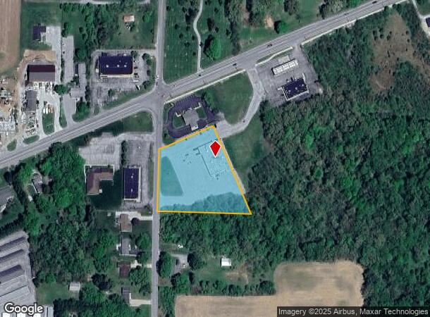
888 W Michigan St
71-01-34-151-007.000-018
IRR TR 2.352 AC BEG 160N OF SW COR NW 1/4 SEC 34-38-1W
Storebuilding
St Joseph
X
Indiana
18091C0185D
2.35 AC
2023
Outlying St Joseph County
2024
South Bend/Mishawaka
010800
South Bend-Mishawaka, IN-MI
12,580 SF
DEMOGRAPHICS near 888 W Michigan St
1 Mile
3 Mile
5 Mile
2024 Total Population
1,547
4,766
7,490
2029 Population
1,465
4,617
7,281
Pop Growth 2024-2029
(5.30%)
(3.13%)
(2.79%)
Average Age
40
42
42
2024 Total Households
596
1,929
3,004
HH Growth 2024-2029
(5.54%)
(3.21%)
(2.86%)
Median Household Inc
$70,637
$72,960
$76,037
Avg Household Size
2.50
2.40
2.40
2024 Avg HH Vehicles
2.00
2.00
2.00
Median Home Value
$189,949
$187,818
$193,569
Median Year Built
1982
1973
1973
Nearby Places
- Restaurants
- Banks
- Shops
- Fitness
- Groceries
PUBLIC TRANSPORTATION
COMMUTER RAIL
Hudson Lake (Laporte County) Station (South Shore Line - Northern Indiana Commuter Transportation District (South Shore Line))
DRIVE
WALK
Distance
Hudson Lake (Laporte County) Station (South Shore Line - Northern Indiana Commuter Transportation District (South Shore Line))
4 min
1.1 mi
AIRPORT
South Bend International
DRIVE
WALK
Distance
South Bend International
27 min
12.8 mi
Freight Ports
Port Milwaukee
DRIVE
WALK
Distance
Port Milwaukee
201 min
162.0 mi
Nearby Properties
Address
Land Use
TOTAL SIZE
Lot Size
Zoning
Address
Land Use
TOTAL SIZE
Lot Size
Zoning
219,230 SF
0.02 AC
Address
Land Use
TOTAL SIZE
Lot Size
Zoning
111,158 SF
0.01 AC
Address
Land Use
TOTAL SIZE
Lot Size
Zoning
103,554 SF
44 SF
Address
Land Use
TOTAL SIZE
Lot Size
Zoning
2,128 SF
0.02 AC
Address
Land Use
TOTAL SIZE
Lot Size
Zoning
7,656 SF
87 SF
Address
Land Use
TOTAL SIZE
Lot Size
Zoning
74,124 SF
7.54 AC
Address
Land Use
TOTAL SIZE
Lot Size
Zoning
70,841 SF
87 SF
Address
Land Use
TOTAL SIZE
Lot Size
Zoning
7,197 SF
174 SF
Address
Land Use
TOTAL SIZE
Lot Size
Zoning
18,433 SF
87 SF
Address
Land Use
TOTAL SIZE
Lot Size
Zoning
26,232 SF
7.35 AC
Address
Land Use
TOTAL SIZE
Lot Size
Zoning
58,400 SF
20 AC
Address
Land Use
TOTAL SIZE
Lot Size
Zoning
17,102 SF
0.01 AC
Address
Land Use
TOTAL SIZE
Lot Size
Zoning
22,720 SF
44 SF
Address
Land Use
TOTAL SIZE
Lot Size
Zoning
Address
Land Use
TOTAL SIZE
Lot Size
Zoning
26,752 SF
0.01 AC
Address
Land Use
TOTAL SIZE
Lot Size
Zoning
4,293 SF
0.03 AC
Address
Land Use
TOTAL SIZE
Lot Size
Zoning
7,727 SF
2.42 AC
Address
Land Use
TOTAL SIZE
Lot Size
Zoning
10,120 SF
3 AC
Address
Land Use
TOTAL SIZE
Lot Size
Zoning
10,296 SF
1.30 AC
Address
Land Use
TOTAL SIZE
Lot Size
Zoning
12,464 SF
4.24 AC
Address
Land Use
TOTAL SIZE
Lot Size
Zoning
4,704 SF
87 SF
Address
Land Use
TOTAL SIZE
Lot Size
Zoning
4,762 SF
0.02 AC
Address
Land Use
TOTAL SIZE
Lot Size
Zoning
6,408 SF
44 SF
Address
Land Use
TOTAL SIZE
Lot Size
Zoning
31,500 SF
3.52 AC
Address
Land Use
TOTAL SIZE
Lot Size
Zoning
4,276 SF
68.50 AC
Address
Land Use
TOTAL SIZE
Lot Size
Zoning
2,820 SF
44 SF
Address
Land Use
TOTAL SIZE
Lot Size
Zoning
331.14 AC
Address
Land Use
TOTAL SIZE
Lot Size
Zoning
5,476 SF
120.64 AC
Address
Land Use
TOTAL SIZE
Lot Size
Zoning
2,465 SF
0.01 AC
Address
Land Use
TOTAL SIZE
Lot Size
Zoning
3,788 SF
82.39 AC
The World's #1 Commercial Real Estate Marketplace
Connect with us
© 2025 CoStar Group
The information above has been obtained from sources believed reliable. While we do not doubt its accuracy we have not verified it and make no guarantee, warranty or representation about it. It is your responsibility to independently confirm its accuracy and completeness. Any projections, opinions, assumptions, or estimates used are for example only and do not represent the current or future performance of the property. The value of this transaction to you depends on tax and other factors which should be evaluated by your tax, financial, and legal advisors. You and your advisors should conduct a careful, independent investigation of the property to determine to your satisfaction the suitability of the property for your needs.