Property Record
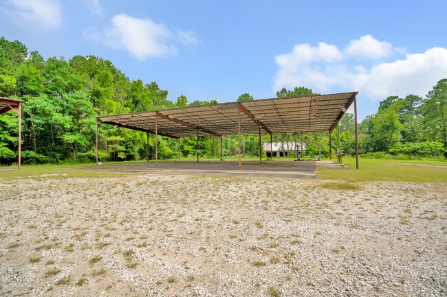
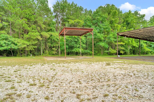
889 Interstate 45 Dr S, Huntsville, TX 77340

Property Detail
889 Interstate 45 Dr S
21164
WALKER R T (A-589), TRACT 5.1, ACRES 5.61
Commercialnec
Walker
B and X Area of moderate flood hazard, usually the area between the limits of the 100-year and 500-year floods.
Texas
2024
5.61 AC
2025
Texas East Area
790700
Other Market Areas
12,536 SF
Huntsville, TX
NEARBY LISTINGS FOR SALE OR LEASE
DEMOGRAPHICS near 889 Interstate 45 Dr S
1 mile
3 mile
5 mile
2025 Total Population
3,988
29,491
42,054
2030 Population
4,352
31,222
44,390
Pop Growth 2025-2030
+ 9.13%
+ 5.87%
+ 5.55%
Average Age
41
33
34
2025 Total Households
1,641
10,450
15,592
HH Growth 2025-2030
+ 10.54%
+ 7.18%
+ 6.64%
Median Household Inc
$64,745
$45,401
$46,051
Avg Household Size
2.20
2.20
2.20
2025 Avg HH Vehicles
2.00
2.00
2.00
Median Home Value
$290,624
$251,012
$241,046
Median Year Built
1988
1991
1988
Nearby Places
Map Layers
Map Styles
 Street
 Aerial
Layers
 Traffic
 Biking
Places
Listings with unknown addresses are not visible on the map
- Restaurants
- Banks
- Shops
- Fitness
- Groceries
SALE & LEASE HISTORY
LISTING DATE
SALE/LEASE

Nov 30, 2022
For Lease
Jun 28, 2021
For Lease
Nearby Properties
Address
Land Use
TOTAL SIZE
Lot Size
Zoning
Address
Land Use
TOTAL SIZE
Lot Size
Zoning
72,835 SF
9.81 AC
Address
Land Use
TOTAL SIZE
Lot Size
Zoning
20,996 SF
8.70 AC
Address
Land Use
TOTAL SIZE
Lot Size
Zoning
147,014 SF
775.19 AC
Address
Land Use
TOTAL SIZE
Lot Size
Zoning
471,882 SF
15.44 AC
Address
Land Use
TOTAL SIZE
Lot Size
Zoning
130,891 SF
23.14 AC
Address
Land Use
TOTAL SIZE
Lot Size
Zoning
142,792 SF
13.76 AC
Address
Land Use
TOTAL SIZE
Lot Size
Zoning
290,351 SF
10.32 AC
Address
Land Use
TOTAL SIZE
Lot Size
Zoning
40,221 SF
2.02 AC
Address
Land Use
TOTAL SIZE
Lot Size
Zoning
414,878 SF
9.50 AC
Address
Land Use
TOTAL SIZE
Lot Size
Zoning
81,707 SF
4.59 AC
Address
Land Use
TOTAL SIZE
Lot Size
Zoning
43,752 SF
1.96 AC
Address
Land Use
TOTAL SIZE
Lot Size
Zoning
296,084 SF
7.44 AC
Address
Land Use
TOTAL SIZE
Lot Size
Zoning
134,276 SF
15.74 AC
Address
Land Use
TOTAL SIZE
Lot Size
Zoning
Address
Land Use
TOTAL SIZE
Lot Size
Zoning
74,188 SF
20.71 AC
Address
Land Use
TOTAL SIZE
Lot Size
Zoning
129,902 SF
5.19 AC
Address
Land Use
TOTAL SIZE
Lot Size
Zoning
41,154 SF
2.09 AC
Address
Land Use
TOTAL SIZE
Lot Size
Zoning
28,142 SF
5.39 AC
Address
Land Use
TOTAL SIZE
Lot Size
Zoning
69,786 SF
12.79 AC
Address
Land Use
TOTAL SIZE
Lot Size
Zoning
297,851 SF
20 AC
Address
Land Use
TOTAL SIZE
Lot Size
Zoning
31,584 SF
2 AC
Address
Land Use
TOTAL SIZE
Lot Size
Zoning
48,000 SF
10.40 AC
Address
Land Use
TOTAL SIZE
Lot Size
Zoning
176,432 SF
4.59 AC
Address
Land Use
TOTAL SIZE
Lot Size
Zoning
10,178 SF
8.51 AC
Address
Land Use
TOTAL SIZE
Lot Size
Zoning
239,530 SF
5.50 AC
Address
Land Use
TOTAL SIZE
Lot Size
Zoning
15,050 SF
10 AC
Address
Land Use
TOTAL SIZE
Lot Size
Zoning
323,197 SF
11.51 AC
Address
Land Use
TOTAL SIZE
Lot Size
Zoning
215,056 SF
4.94 AC
Address
Land Use
TOTAL SIZE
Lot Size
Zoning
6,000 SF
8.40 AC
Address
Land Use
TOTAL SIZE
Lot Size
Zoning
50,570 SF
5.50 AC
The World's #1 Commercial Real Estate Marketplace
Connect with us
© 2026 CoStar Group
The information above has been obtained from sources believed reliable. While we do not doubt its accuracy we have not verified it and make no guarantee, warranty or representation about it. It is your responsibility to independently confirm its accuracy and completeness. Any projections, opinions, assumptions, or estimates used are for example only and do not represent the current or future performance of the property. The value of this transaction to you depends on tax and other factors which should be evaluated by your tax, financial, and legal advisors. You and your advisors should conduct a careful, independent investigation of the property to determine to your satisfaction the suitability of the property for your needs.