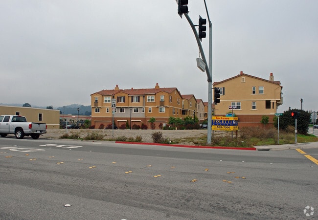
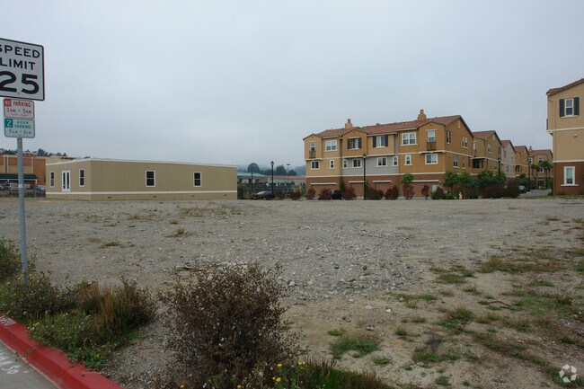
Property Record
889 Mc Lellan Dr, South San Francisco, CA 94080


NEARBY LISTINGS FOR SALE OR LEASE
-
-
-
-
No Photo
-
-
-
-
View all South San Francisco listings for sale on LoopNet.com
Property Detail
889 Mc Lellan Dr
010-213-070
ON SLY LN OF MISSION RD ADJ TO PAR 2 OF PM VOL 67/19-21
Multifamilydwelling
San Mateo
X
California
06081C0037E
0.40 AC
2024
South San Francisco
2025
San Francisco
601902
San Francisco-Redwood City-South San Francisco, CA
DEMOGRAPHICS near 889 Mc Lellan Dr
1 Mile
3 Mile
5 Mile
2024 Total Population
19,659
184,440
384,089
2029 Population
18,684
174,783
358,168
Pop Growth 2024-2029
(4.96%)
(5.24%)
(6.75%)
Average Age
43
42
43
2024 Total Households
6,806
59,122
123,382
HH Growth 2024-2029
(5.11%)
(5.43%)
(6.93%)
Median Household Inc
$120,063
$112,393
$110,869
Avg Household Size
2.80
3.00
3.00
2024 Avg HH Vehicles
2.00
2.00
2.00
Median Home Value
$1,061,947
$1,036,087
$1,054,709
Median Year Built
1959
1966
1959
Nearby Places
Map Layers
Map Styles
 Street
 Aerial
- Restaurants
- Banks
- Shops
- Fitness
- Groceries
PUBLIC TRANSPORTATION
TRANSIT/SUBWAY
South San Francisco Station (Dublin/Pleasanton - Millbrae - Bay Area Rapid Transit (BART), Pittsburg/Bay Point - San Francisco International - Bay Area Rapid Transit (BART), Richmond - Millbrae - Bay Area Rapid Transit (BART))
DRIVE
WALK
Distance
South San Francisco Station (Dublin/Pleasanton - Millbrae - Bay Area Rapid Transit (BART), Pittsburg/Bay Point - San Francisco International - Bay Area Rapid Transit (BART), Richmond - Millbrae - Bay Area Rapid Transit (BART))
1 min
3 min
0.1 mi
COMMUTER RAIL
South San Francisco (Caltrain - Caltrain (Caltrain))
DRIVE
WALK
Distance
South San Francisco (Caltrain - Caltrain (Caltrain))
7 min
3.0 mi
DRIVE
WALK
Distance
6 min
3.4 mi
AIRPORT
San Francisco International
DRIVE
WALK
Distance
San Francisco International
12 min
5.9 mi
Metro Oakland International
DRIVE
WALK
Distance
Metro Oakland International
45 min
30.9 mi
Norman Y Mineta San Jose International
DRIVE
WALK
Distance
Norman Y Mineta San Jose International
49 min
37.7 mi
Freight Ports
Port of San Francisco
DRIVE
WALK
Distance
Port of San Francisco
21 min
14.3 mi
Nearby Properties
Address
Land Use
TOTAL SIZE
Lot Size
Zoning
Address
Land Use
TOTAL SIZE
Lot Size
Zoning
Address
Land Use
TOTAL SIZE
Lot Size
Zoning
6.67 AC
PD0000
Address
Land Use
TOTAL SIZE
Lot Size
Zoning
350,036 SF
2.91 AC
Address
Land Use
TOTAL SIZE
Lot Size
Zoning
323,091 SF
14.83 AC
Address
Land Use
TOTAL SIZE
Lot Size
Zoning
Address
Land Use
TOTAL SIZE
Lot Size
Zoning
529,342 SF
5.28 AC
Address
Land Use
TOTAL SIZE
Lot Size
Zoning
4,047 SF
4.25 AC
Address
Land Use
TOTAL SIZE
Lot Size
Zoning
293,445 SF
6.70 AC
MH00M2
Address
Land Use
TOTAL SIZE
Lot Size
Zoning
53.85 AC
Address
Land Use
TOTAL SIZE
Lot Size
Zoning
152,145 SF
6.10 AC
MH00M2
Address
Land Use
TOTAL SIZE
Lot Size
Zoning
176,096 SF
2.74 AC
Address
Land Use
TOTAL SIZE
Lot Size
Zoning
2,016 SF
3.61 AC
Address
Land Use
TOTAL SIZE
Lot Size
Zoning
2,007 SF
7.66 AC
Address
Land Use
TOTAL SIZE
Lot Size
Zoning
112,912 SF
5.96 AC
MH00M2
Address
Land Use
TOTAL SIZE
Lot Size
Zoning
198,375 SF
5.52 AC
PD0000
Address
Land Use
TOTAL SIZE
Lot Size
Zoning
126,971 SF
3.04 AC
Address
Land Use
TOTAL SIZE
Lot Size
Zoning
Address
Land Use
TOTAL SIZE
Lot Size
Zoning
312,191 SF
2.74 AC
Address
Land Use
TOTAL SIZE
Lot Size
Zoning
141,677 SF
8.57 AC
Address
Land Use
TOTAL SIZE
Lot Size
Zoning
210,895 SF
2.89 AC
Address
Land Use
TOTAL SIZE
Lot Size
Zoning
2,003 SF
4.88 AC
Address
Land Use
TOTAL SIZE
Lot Size
Zoning
321,315 SF
6.18 AC
Address
Land Use
TOTAL SIZE
Lot Size
Zoning
2,023 SF
2.98 AC
MH00M2
Address
Land Use
TOTAL SIZE
Lot Size
Zoning
202,006 SF
3.16 AC
Address
Land Use
TOTAL SIZE
Lot Size
Zoning
Address
Land Use
TOTAL SIZE
Lot Size
Zoning
167,105 SF
2.07 AC
C10000
Address
Land Use
TOTAL SIZE
Lot Size
Zoning
270,980 SF
3.33 AC
Address
Land Use
TOTAL SIZE
Lot Size
Zoning
453,076 SF
25.10 AC
Address
Land Use
TOTAL SIZE
Lot Size
Zoning
42.95 AC
Address
Land Use
TOTAL SIZE
Lot Size
Zoning
86,000 SF
4.90 AC
PD0000
The World's #1 Commercial Real Estate Marketplace
Connect with us
© 2026 CoStar Group
The information above has been obtained from sources believed reliable. While we do not doubt its accuracy we have not verified it and make no guarantee, warranty or representation about it. It is your responsibility to independently confirm its accuracy and completeness. Any projections, opinions, assumptions, or estimates used are for example only and do not represent the current or future performance of the property. The value of this transaction to you depends on tax and other factors which should be evaluated by your tax, financial, and legal advisors. You and your advisors should conduct a careful, independent investigation of the property to determine to your satisfaction the suitability of the property for your needs.