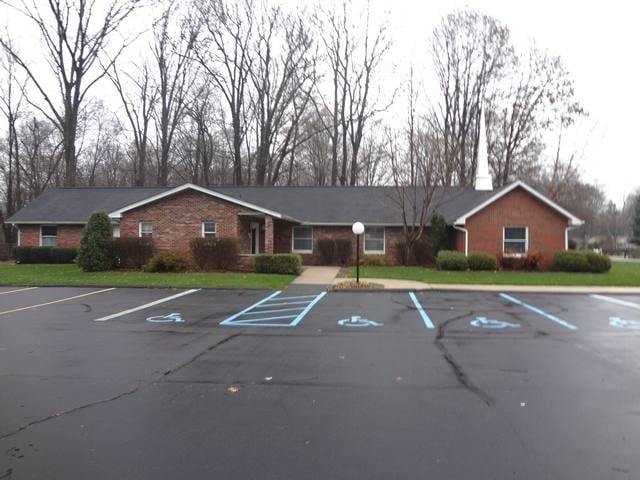
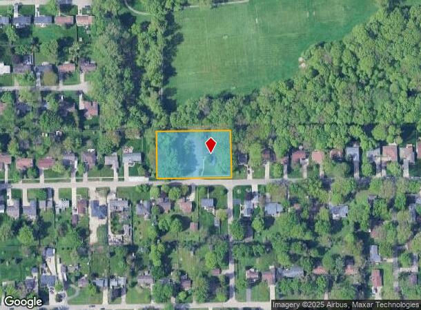
Property Record
8891 Messmore Rd, Shelby Township, MI 48317
Current Lease Availabilities
NEARBY LISTINGS FOR SALE OR LEASE
Property Detail
8891 Messmore Rd
23-07-34-104-019
L 626B1 T3N R12E SEC 34 COMM AT W 1/4 POST SEC 34, TH N 1 DEG 4' 30" W 1222.51 FT, TH N 89 DEG 17' E 2338.16 FT TO PT BEG, TH
Commercialnec
Macomb
X
Michigan
26099C0219G
1.38 AC
0
Macomb West
2025
Detroit
225900
Detroit-Warren-Dearborn, MI
900 SF
DEMOGRAPHICS near 8891 Messmore Rd
1 Mile
3 Mile
5 Mile
2024 Total Population
8,640
78,291
231,863
2029 Population
8,502
77,153
228,876
Pop Growth 2024-2029
(1.60%)
(1.45%)
(1.29%)
Average Age
43
43
42
2024 Total Households
3,594
32,620
92,315
HH Growth 2024-2029
(1.73%)
(1.59%)
(1.32%)
Median Household Inc
$71,511
$71,564
$80,421
Avg Household Size
2.40
2.30
2.50
2024 Avg HH Vehicles
2.00
2.00
2.00
Median Home Value
$242,661
$244,984
$264,584
Median Year Built
1972
1982
1985
Nearby Places
Map Layers
Map Styles
 Street
 Aerial
- Restaurants
- Banks
- Shops
- Fitness
- Groceries
PUBLIC TRANSPORTATION
AIRPORT
Windsor International
DRIVE
WALK
Distance
Windsor International
62 min
36.1 mi
Freight Ports
Port of Toledo
DRIVE
WALK
Distance
Port of Toledo
113 min
86.7 mi
Nearby Properties
Address
Land Use
TOTAL SIZE
Lot Size
Zoning
Address
Land Use
TOTAL SIZE
Lot Size
Zoning
998,316 SF
85.99 AC
CK MAP
Address
Land Use
TOTAL SIZE
Lot Size
Zoning
447,434 SF
23.29 AC
LM
Address
Land Use
TOTAL SIZE
Lot Size
Zoning
92.30 AC
MHP
Address
Land Use
TOTAL SIZE
Lot Size
Zoning
2,058,062 SF
141.65 AC
M-2
Address
Land Use
TOTAL SIZE
Lot Size
Zoning
366,656 SF
30.08 AC
RM-2
Address
Land Use
TOTAL SIZE
Lot Size
Zoning
332,286 SF
CK MAP
Address
Land Use
TOTAL SIZE
Lot Size
Zoning
46.56 AC
CK MAP
Address
Land Use
TOTAL SIZE
Lot Size
Zoning
283,249 SF
M-2
Address
Land Use
TOTAL SIZE
Lot Size
Zoning
1,150 SF
25.68 AC
CK MAP
Address
Land Use
TOTAL SIZE
Lot Size
Zoning
242,857 SF
9.61 AC
RM-3
Address
Land Use
TOTAL SIZE
Lot Size
Zoning
34.43 AC
CK MAP
Address
Land Use
TOTAL SIZE
Lot Size
Zoning
438,578 SF
36.60 AC
MXD
Address
Land Use
TOTAL SIZE
Lot Size
Zoning
25.18 AC
RM-2
Address
Land Use
TOTAL SIZE
Lot Size
Zoning
41.09 AC
R-7
Address
Land Use
TOTAL SIZE
Lot Size
Zoning
190,996 SF
33.80 AC
LM
Address
Land Use
TOTAL SIZE
Lot Size
Zoning
255,070 SF
20.33 AC
RM-2
Address
Land Use
TOTAL SIZE
Lot Size
Zoning
237,108 SF
10.30 AC
R-12
Address
Land Use
TOTAL SIZE
Lot Size
Zoning
29.93 AC
RM-2
Address
Land Use
TOTAL SIZE
Lot Size
Zoning
181,725 SF
CK MAP
Address
Land Use
TOTAL SIZE
Lot Size
Zoning
29.39 AC
CK MAP
Address
Land Use
TOTAL SIZE
Lot Size
Zoning
224,323 SF
22.15 AC
C-3
Address
Land Use
TOTAL SIZE
Lot Size
Zoning
1,350 SF
21.90 AC
CK MAP
Address
Land Use
TOTAL SIZE
Lot Size
Zoning
167,747 SF
CK MAP
Address
Land Use
TOTAL SIZE
Lot Size
Zoning
17.40 AC
CK MAP
Address
Land Use
TOTAL SIZE
Lot Size
Zoning
554,374 SF
22.15 AC
M-2
Address
Land Use
TOTAL SIZE
Lot Size
Zoning
73.49 AC
CK MAP
Address
Land Use
TOTAL SIZE
Lot Size
Zoning
210,080 SF
14.35 AC
RM-2
Address
Land Use
TOTAL SIZE
Lot Size
Zoning
50,577 SF
21.43 AC
C-2
Address
Land Use
TOTAL SIZE
Lot Size
Zoning
128,364 SF
40.11 AC
C-4
Address
Land Use
TOTAL SIZE
Lot Size
Zoning
176,212 SF
16.46 AC
MXD
The World's #1 Commercial Real Estate Marketplace
Connect with us
© 2025 CoStar Group
The information above has been obtained from sources believed reliable. While we do not doubt its accuracy we have not verified it and make no guarantee, warranty or representation about it. It is your responsibility to independently confirm its accuracy and completeness. Any projections, opinions, assumptions, or estimates used are for example only and do not represent the current or future performance of the property. The value of this transaction to you depends on tax and other factors which should be evaluated by your tax, financial, and legal advisors. You and your advisors should conduct a careful, independent investigation of the property to determine to your satisfaction the suitability of the property for your needs.