Property Record
8773 Boynton Beach Blvd, Boynton Beach, FL 33472

NEARBY LISTINGS FOR SALE OR LEASE
Property Detail
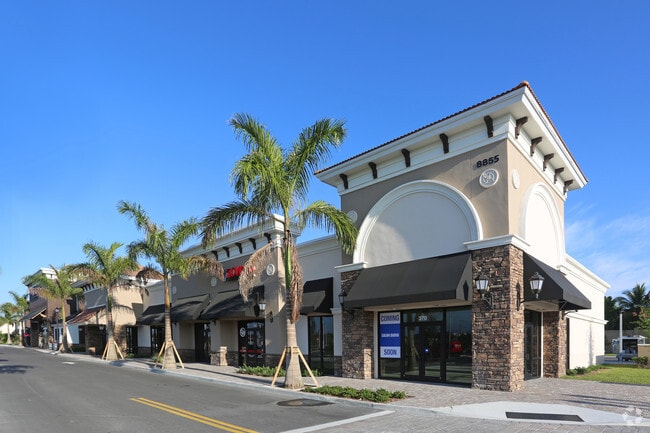
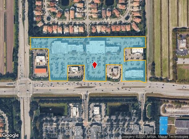
8773 Boynton Beach Blvd
00-42-45-20-07-001-0010
Cobblestone Plaza Par A
Regionalshoppingcenterormallwithanchorstore
PORITON LOT A
X
Palm Beach
12099C0770F
Florida
2024
10.85 AC
2025
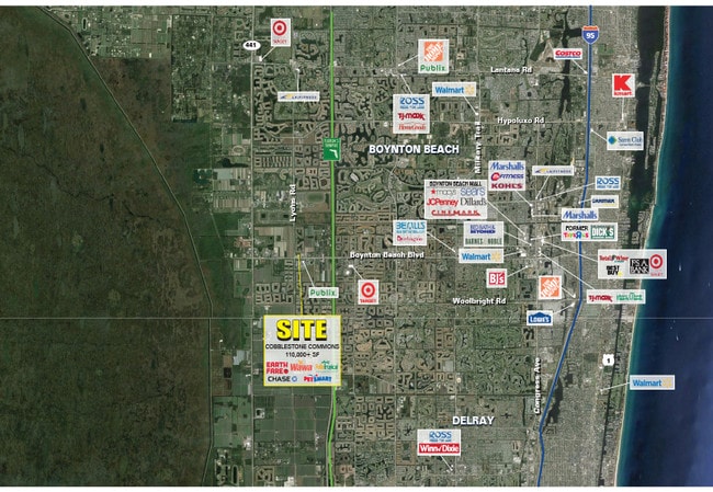
Boynton/Lantana
007772
South Florida
88,456 SF
West Palm Beach-Boca Raton-Delray Beach, FL
DEMOGRAPHICS near 8773 Boynton Beach Blvd
1 Mile
3 Mile
5 Mile
2024 Total Population
3,963
48,232
130,652
2029 Population
4,023
49,404
134,606
Pop Growth 2024-2029
+ 1.51%
+ 2.43%
+ 3.03%
Average Age
44
53
52
2024 Total Households
1,240
20,110
56,505
HH Growth 2024-2029
+ 0.56%
+ 1.91%
+ 2.74%
Median Household Inc
$120,937
$94,386
$81,496
Avg Household Size
2.80
2.30
2.20
2024 Avg HH Vehicles
2.00
2.00
2.00
Median Home Value
$677,680
$434,462
$377,261
Median Year Built
2010
2002
1996
Nearby Places
Map Layers
Map Styles
 Street
 Aerial
- Restaurants
- Banks
- Shops
- Fitness
- Groceries
PUBLIC TRANSPORTATION
COMMUTER RAIL
Boynton Beach (Mangonia Park - Miami Airport - Tri-Rail, Tri-County Commuter - Tri-Rail)
DRIVE
WALK
Distance
Boynton Beach (Mangonia Park - Miami Airport - Tri-Rail, Tri-County Commuter - Tri-Rail)
19 min
9.1 mi
AIRPORT
Palm Beach International
DRIVE
WALK
Distance
Palm Beach International
24 min
17.1 mi
Freight Ports
Port of Palm Beach
DRIVE
WALK
Distance
Port of Palm Beach
37 min
24.3 mi
SALE & LEASE HISTORY
LISTING DATE
SALE/LEASE

Jan 29, 2021
For Lease
Aug 21, 2018
For Lease
Nearby Properties
Address
Land Use
TOTAL SIZE
Lot Size
Zoning
Address
Land Use
TOTAL SIZE
Lot Size
Zoning
259,086 SF
44.59 AC
MUPD
Address
Land Use
TOTAL SIZE
Lot Size
Zoning
410,663 SF
22.50 AC
PUD
Address
Land Use
TOTAL SIZE
Lot Size
Zoning
298,137 SF
17.93 AC
PUD
Address
Land Use
TOTAL SIZE
Lot Size
Zoning
342,500 SF
33.52 AC
PUD
Address
Land Use
TOTAL SIZE
Lot Size
Zoning
149,268 SF
16.85 AC
MUPD
Address
Land Use
TOTAL SIZE
Lot Size
Zoning
271,613 SF
33 AC
MUPD/P
Address
Land Use
TOTAL SIZE
Lot Size
Zoning
145,825 SF
33.59 AC
MUPD
Address
Land Use
TOTAL SIZE
Lot Size
Zoning
161,858 SF
19.49 AC
MUPD
Address
Land Use
TOTAL SIZE
Lot Size
Zoning
671,429 SF
245.66 AC
AGRPUD/P
Address
Land Use
TOTAL SIZE
Lot Size
Zoning
69,092 SF
7.75 AC
MUPD
Address
Land Use
TOTAL SIZE
Lot Size
Zoning
208,268 SF
27.30 AC
AR
Address
Land Use
TOTAL SIZE
Lot Size
Zoning
91,115 SF
13.27 AC
CG
Address
Land Use
TOTAL SIZE
Lot Size
Zoning
146,573 SF
7.50 AC
MUPD
Address
Land Use
TOTAL SIZE
Lot Size
Zoning
113,918 SF
5.30 AC
CG
Address
Land Use
TOTAL SIZE
Lot Size
Zoning
160,199 SF
30 AC
RS
Address
Land Use
TOTAL SIZE
Lot Size
Zoning
51,988 SF
6.26 AC
CG
Address
Land Use
TOTAL SIZE
Lot Size
Zoning
89,511 SF
14.73 AC
MUPD
Address
Land Use
TOTAL SIZE
Lot Size
Zoning
88,125 SF
13.92 AC
AGR
Address
Land Use
TOTAL SIZE
Lot Size
Zoning
4,488 SF
52.12 AC
MUPD/P
Address
Land Use
TOTAL SIZE
Lot Size
Zoning
4,800 SF
39.40 AC
MUPD/P
Address
Land Use
TOTAL SIZE
Lot Size
Zoning
134,643 SF
12.92 AC
PUD
Address
Land Use
TOTAL SIZE
Lot Size
Zoning
179,196 SF
23.87 AC
MUPD
Address
Land Use
TOTAL SIZE
Lot Size
Zoning
97,182 SF
77.58 AC
IPF
Address
Land Use
TOTAL SIZE
Lot Size
Zoning
67,907 SF
0.68 AC
MUPD
Address
Land Use
TOTAL SIZE
Lot Size
Zoning
72,299 SF
10.76 AC
MUPD
Address
Land Use
TOTAL SIZE
Lot Size
Zoning
70,086 SF
5.31 AC
PUD
Address
Land Use
TOTAL SIZE
Lot Size
Zoning
55.61 AC
AR
Address
Land Use
TOTAL SIZE
Lot Size
Zoning
49,884 SF
4.94 AC
CHO
Address
Land Use
TOTAL SIZE
Lot Size
Zoning
49,708 SF
4.24 AC
MUPD
The World's #1 Commercial Real Estate Marketplace
Connect with us
© 2026 CoStar Group
The information above has been obtained from sources believed reliable. While we do not doubt its accuracy we have not verified it and make no guarantee, warranty or representation about it. It is your responsibility to independently confirm its accuracy and completeness. Any projections, opinions, assumptions, or estimates used are for example only and do not represent the current or future performance of the property. The value of this transaction to you depends on tax and other factors which should be evaluated by your tax, financial, and legal advisors. You and your advisors should conduct a careful, independent investigation of the property to determine to your satisfaction the suitability of the property for your needs.