Property Record
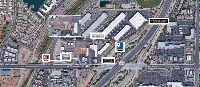
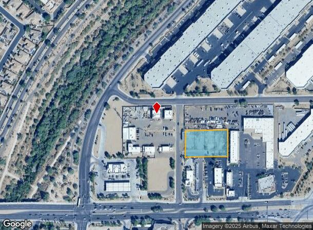
14128 N 88Th Ave, Peoria, AZ 85381
NEARBY LISTINGS FOR SALE OR LEASE
Property Detail
14128 N 88Th Ave
Phoenix-Mesa-Chandler, AZ
88Th Avenue & Thunderbird Commercial
200-63-694
88TH AVENUE & THUNDERBIRD COMMERCIAL MCR 1311-22
Commercialacreage
Maricopa
X
Arizona
04013C1705M
2
2025
1.05 AC
2025
Arrowhead
071515
Phoenix
DEMOGRAPHICS near 14128 N 88Th Ave
1 mile
3 mile
5 mile
2024 Total Population
14,079
114,694
318,440
2029 Population
15,206
124,233
344,388
Pop Growth 2024-2029
+ 8.00%
+ 8.32%
+ 8.15%
Average Age
43
48
44
2024 Total Households
6,071
49,739
127,939
HH Growth 2024-2029
+ 8.04%
+ 8.54%
+ 8.36%
Median Household Inc
$68,259
$60,641
$64,409
Avg Household Size
2.20
2.20
2.40
2024 Avg HH Vehicles
2.00
2.00
2.00
Median Home Value
$341,860
$281,669
$301,919
Median Year Built
1993
1984
1987
Nearby Places
Map Layers
Map Styles
 Street
 Aerial
Transit
 Traffic
 Biking
Places
Listings with unknown addresses are not visible on the map
- Restaurants
- Banks
- Shops
- Fitness
- Groceries
PUBLIC TRANSPORTATION
AIRPORT
Phoenix Sky Harbor International
Drive
Walk
Distance
Phoenix Sky Harbor International
37 min
28.7 mi
Freight Ports
Port of San Diego
Drive
Walk
Distance
Port of San Diego
394 min
354.6 mi
SALE & LEASE HISTORY
LISTING DATE
SALE/LEASE

Jan 08, 2018
For Sale
Nearby Properties
Address
Land Use
TOTAL SIZE
Lot Size
Zoning
Address
Land Use
TOTAL SIZE
Lot Size
Zoning
81,100 SF
9.48 AC
PAD
Address
Land Use
TOTAL SIZE
Lot Size
Zoning
45,900 SF
11.09 AC
PAD
Address
Land Use
TOTAL SIZE
Lot Size
Zoning
1,010,365 SF
29.94 AC
C2
Address
Land Use
TOTAL SIZE
Lot Size
Zoning
708,928 SF
44.86 AC
Address
Land Use
TOTAL SIZE
Lot Size
Zoning
238,942 SF
36.87 AC
R1-8
Address
Land Use
TOTAL SIZE
Lot Size
Zoning
1,113,127 SF
48.24 AC
C2
Address
Land Use
TOTAL SIZE
Lot Size
Zoning
19.95 AC
AG
Address
Land Use
TOTAL SIZE
Lot Size
Zoning
359,639 SF
16.29 AC
PAD
Address
Land Use
TOTAL SIZE
Lot Size
Zoning
303,051 SF
9.11 AC
AG
Address
Land Use
TOTAL SIZE
Lot Size
Zoning
348,803 SF
15.91 AC
PAD
Address
Land Use
TOTAL SIZE
Lot Size
Zoning
547,083 SF
10.94 AC
C-C
Address
Land Use
TOTAL SIZE
Lot Size
Zoning
353,859 SF
11.71 AC
PAD
Address
Land Use
TOTAL SIZE
Lot Size
Zoning
366,400 SF
19.99 AC
PAD
Address
Land Use
TOTAL SIZE
Lot Size
Zoning
318,282 SF
15.23 AC
PAD
Address
Land Use
TOTAL SIZE
Lot Size
Zoning
325,529 SF
10.85 AC
PAD
Address
Land Use
TOTAL SIZE
Lot Size
Zoning
440,494 SF
26.25 AC
PAD
Address
Land Use
TOTAL SIZE
Lot Size
Zoning
392,885 SF
17.67 AC
M-H
Address
Land Use
TOTAL SIZE
Lot Size
Zoning
375,604 SF
6.31 AC
M-M
Address
Land Use
TOTAL SIZE
Lot Size
Zoning
284,715 SF
7.15 AC
M-M
Address
Land Use
TOTAL SIZE
Lot Size
Zoning
245,400 SF
22.90 AC
PAD
Address
Land Use
TOTAL SIZE
Lot Size
Zoning
115,027 SF
14.46 AC
R-8
Address
Land Use
TOTAL SIZE
Lot Size
Zoning
150,002 SF
10.91 AC
C-C
Address
Land Use
TOTAL SIZE
Lot Size
Zoning
283,107 SF
14.60 AC
M-M
Address
Land Use
TOTAL SIZE
Lot Size
Zoning
319,723 SF
10.79 AC
PAD
Address
Land Use
TOTAL SIZE
Lot Size
Zoning
86,343 SF
13.52 AC
M-M
Address
Land Use
TOTAL SIZE
Lot Size
Zoning
210,605 SF
6.76 AC
PAD
Address
Land Use
TOTAL SIZE
Lot Size
Zoning
82,688 SF
18.70 AC
PAD
Address
Land Use
TOTAL SIZE
Lot Size
Zoning
230,076 SF
14.03 AC
PAD
Address
Land Use
TOTAL SIZE
Lot Size
Zoning
301,213 SF
18.86 AC
PAD
Address
Land Use
TOTAL SIZE
Lot Size
Zoning
156,940 SF
20.76 AC
PAD
The World's #1 Commercial Real Estate Marketplace
Connect with us
© 2026 CoStar Group
The information above has been obtained from sources believed reliable. While we do not doubt its accuracy we have not verified it and make no guarantee, warranty or representation about it. It is your responsibility to independently confirm its accuracy and completeness. Any projections, opinions, assumptions, or estimates used are for example only and do not represent the current or future performance of the property. The value of this transaction to you depends on tax and other factors which should be evaluated by your tax, financial, and legal advisors. You and your advisors should conduct a careful, independent investigation of the property to determine to your satisfaction the suitability of the property for your needs.