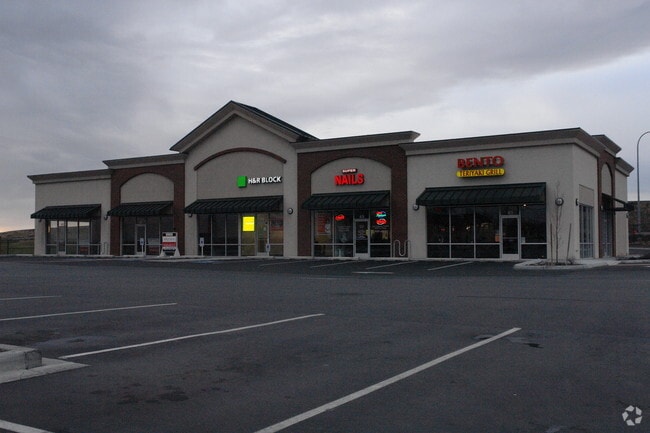
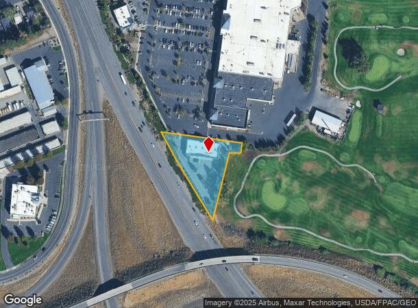
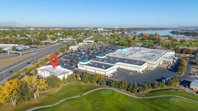
Property Record
89 Columbia Point Dr, Richland, WA 99352
NEARBY LISTINGS FOR SALE OR LEASE
Property Detail
89 Columbia Point Dr
Other Market Areas
Binding Site 2892
Kennewick-Richland, WA
SECTION 13 TOWNSHIP 9 RANGE 28 BINDING SITE PLAN #2892 LOT 4 AF#01-015336
113983BP2892004
Benton
Storebuilding
Washington
2024
4
2024
1.11 AC
010600
Yakima/Kennewick
7,830 SF
DEMOGRAPHICS near 89 Columbia Point Dr
1 Mile
3 Mile
5 Mile
2024 Total Population
4,723
58,966
136,933
2029 Population
5,095
63,490
147,734
Pop Growth 2024-2029
+ 7.88%
+ 7.67%
+ 7.89%
Average Age
37
38
38
2024 Total Households
1,956
22,921
50,757
HH Growth 2024-2029
+ 8.08%
+ 7.61%
+ 7.86%
Median Household Inc
$59,395
$86,549
$91,584
Avg Household Size
2.40
2.50
2.70
2024 Avg HH Vehicles
2.00
2.00
2.00
Median Home Value
$366,751
$356,561
$357,822
Median Year Built
1962
1991
1997
Nearby Places
Map Layers
Map Styles
 Street
 Aerial
- Restaurants
- Banks
- Shops
- Fitness
- Groceries
PUBLIC TRANSPORTATION
AIRPORT
Tri-Cities
DRIVE
WALK
Distance
Tri-Cities
17 min
9.7 mi
Freight Ports
Port of Tacoma
DRIVE
WALK
Distance
Port of Tacoma
264 min
229.4 mi
SALE & LEASE HISTORY
LISTING DATE
SALE/LEASE

Sep 06, 2018
For Lease
Oct 27, 2023
For Sale
Jun 05, 2018
For Sale
Nearby Properties
Address
Land Use
TOTAL SIZE
Lot Size
Zoning
Address
Land Use
TOTAL SIZE
Lot Size
Zoning
562,186 SF
7.61 AC
Address
Land Use
TOTAL SIZE
Lot Size
Zoning
277,530 SF
14.99 AC
Address
Land Use
TOTAL SIZE
Lot Size
Zoning
378,471 SF
16.21 AC
RICHLAND -
Address
Land Use
TOTAL SIZE
Lot Size
Zoning
183,204 SF
14.94 AC
Address
Land Use
TOTAL SIZE
Lot Size
Zoning
342,771 SF
11.59 AC
Address
Land Use
TOTAL SIZE
Lot Size
Zoning
143,592 SF
6.86 AC
RICHLAND -
Address
Land Use
TOTAL SIZE
Lot Size
Zoning
428,225 SF
12.60 AC
Address
Land Use
TOTAL SIZE
Lot Size
Zoning
238,088 SF
17.06 AC
Address
Land Use
TOTAL SIZE
Lot Size
Zoning
351,217 SF
60.86 AC
Address
Land Use
TOTAL SIZE
Lot Size
Zoning
236,556 SF
11.34 AC
Address
Land Use
TOTAL SIZE
Lot Size
Zoning
Address
Land Use
TOTAL SIZE
Lot Size
Zoning
185,302 SF
9.13 AC
Address
Land Use
TOTAL SIZE
Lot Size
Zoning
183,266 SF
10 AC
Address
Land Use
TOTAL SIZE
Lot Size
Zoning
220,970 SF
1.28 AC
Address
Land Use
TOTAL SIZE
Lot Size
Zoning
200,734 SF
12.38 AC
Address
Land Use
TOTAL SIZE
Lot Size
Zoning
216,270 SF
22.32 AC
Address
Land Use
TOTAL SIZE
Lot Size
Zoning
144,723 SF
6.88 AC
Address
Land Use
TOTAL SIZE
Lot Size
Zoning
113,052 SF
3.32 AC
Address
Land Use
TOTAL SIZE
Lot Size
Zoning
81,497 SF
16.69 AC
Address
Land Use
TOTAL SIZE
Lot Size
Zoning
69,488 SF
1.69 AC
Address
Land Use
TOTAL SIZE
Lot Size
Zoning
170,307 SF
14.15 AC
Address
Land Use
TOTAL SIZE
Lot Size
Zoning
109,517 SF
4.67 AC
Address
Land Use
TOTAL SIZE
Lot Size
Zoning
157,320 SF
3.80 AC
53
Address
Land Use
TOTAL SIZE
Lot Size
Zoning
116,283 SF
11.18 AC
RICHLAND -
Address
Land Use
TOTAL SIZE
Lot Size
Zoning
116,318 SF
2.74 AC
Address
Land Use
TOTAL SIZE
Lot Size
Zoning
74,089 SF
12.33 AC
Address
Land Use
TOTAL SIZE
Lot Size
Zoning
76,249 SF
13 AC
Address
Land Use
TOTAL SIZE
Lot Size
Zoning
96,486 SF
13.24 AC
Address
Land Use
TOTAL SIZE
Lot Size
Zoning
154,818 SF
16.84 AC
KENNEWICK
Address
Land Use
TOTAL SIZE
Lot Size
Zoning
76,234 SF
7.32 AC
58
The World's #1 Commercial Real Estate Marketplace
Connect with us
© 2025 CoStar Group
The information above has been obtained from sources believed reliable. While we do not doubt its accuracy we have not verified it and make no guarantee, warranty or representation about it. It is your responsibility to independently confirm its accuracy and completeness. Any projections, opinions, assumptions, or estimates used are for example only and do not represent the current or future performance of the property. The value of this transaction to you depends on tax and other factors which should be evaluated by your tax, financial, and legal advisors. You and your advisors should conduct a careful, independent investigation of the property to determine to your satisfaction the suitability of the property for your needs.