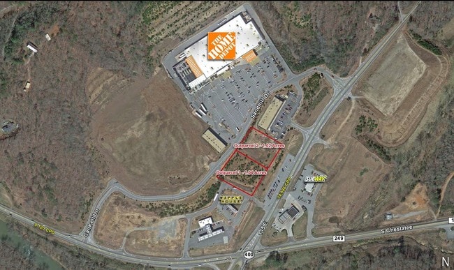
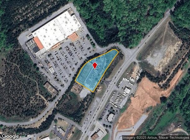
Property Record
89 Long Branch Rd, Dahlonega, GA 30533
NEARBY LISTINGS FOR SALE OR LEASE
Property Detail
89 Long Branch Rd
082-000-257-000
Commer Rural@200K A
Storesoffices
1.81 ACS SHOP 1 LL 162 LD 11
X
Lumpkin
13139C0075G
Georgia
2024
1.81 AC
2024
Alpharetta/North
960104
Other Market Areas
15,050 SF
Atlanta-Sandy Springs-Roswell, GA
DEMOGRAPHICS near 89 Long Branch Rd
1 Mile
3 Mile
5 Mile
2024 Total Population
419
5,929
20,605
2029 Population
467
6,611
23,258
Pop Growth 2024-2029
+ 11.46%
+ 11.50%
+ 12.88%
Average Age
44
41
39
2024 Total Households
165
2,134
6,818
HH Growth 2024-2029
+ 10.91%
+ 11.43%
+ 13.24%
Median Household Inc
$93,749
$81,440
$69,701
Avg Household Size
2.60
2.60
2.50
2024 Avg HH Vehicles
2.00
2.00
2.00
Median Home Value
$319,047
$243,614
$278,680
Median Year Built
2002
1999
1997
Nearby Places
Map Layers
Map Styles
 Street
 Aerial
- Restaurants
- Banks
- Shops
- Fitness
- Groceries
SALE & LEASE HISTORY
LISTING DATE
SALE/LEASE

Sep 24, 2016
For Sale
Feb 01, 2018
For Sale
Nearby Properties
Address
Land Use
TOTAL SIZE
Lot Size
Zoning
Address
Land Use
TOTAL SIZE
Lot Size
Zoning
65,477 SF
57.12 AC
GO
Address
Land Use
TOTAL SIZE
Lot Size
Zoning
104,692 SF
9.20 AC
GC
Address
Land Use
TOTAL SIZE
Lot Size
Zoning
1,230.70 AC
AP
Address
Land Use
TOTAL SIZE
Lot Size
Zoning
52,000 SF
4.46 AC
I
Address
Land Use
TOTAL SIZE
Lot Size
Zoning
89,315 SF
8.97 AC
I
Address
Land Use
TOTAL SIZE
Lot Size
Zoning
75.73 AC
GO
Address
Land Use
TOTAL SIZE
Lot Size
Zoning
513 AC
RG
Address
Land Use
TOTAL SIZE
Lot Size
Zoning
91.91 AC
GO
Address
Land Use
TOTAL SIZE
Lot Size
Zoning
253.58 AC
AR-1
Address
Land Use
TOTAL SIZE
Lot Size
Zoning
70,000 SF
9.66 AC
GO
Address
Land Use
TOTAL SIZE
Lot Size
Zoning
32,840 SF
6.15 AC
R1
Address
Land Use
TOTAL SIZE
Lot Size
Zoning
33,617 SF
3.06 AC
I
Address
Land Use
TOTAL SIZE
Lot Size
Zoning
19,806 SF
4.69 AC
I
Address
Land Use
TOTAL SIZE
Lot Size
Zoning
298.37 AC
GC
Address
Land Use
TOTAL SIZE
Lot Size
Zoning
75 AC
GO
Address
Land Use
TOTAL SIZE
Lot Size
Zoning
45,700 SF
4.73 AC
I
Address
Land Use
TOTAL SIZE
Lot Size
Zoning
2,000 SF
10.70 AC
I
Address
Land Use
TOTAL SIZE
Lot Size
Zoning
1,008 SF
404.11 AC
I
Address
Land Use
TOTAL SIZE
Lot Size
Zoning
44.65 AC
GO
Address
Land Use
TOTAL SIZE
Lot Size
Zoning
558 AC
AP
Address
Land Use
TOTAL SIZE
Lot Size
Zoning
18.23 AC
GO
Address
Land Use
TOTAL SIZE
Lot Size
Zoning
31,824 SF
9.28 AC
RG
Address
Land Use
TOTAL SIZE
Lot Size
Zoning
22,596 SF
10.65 AC
CC
Address
Land Use
TOTAL SIZE
Lot Size
Zoning
40,000 SF
3.21 AC
I
Address
Land Use
TOTAL SIZE
Lot Size
Zoning
458 AC
AP
Address
Land Use
TOTAL SIZE
Lot Size
Zoning
6,400 SF
182.10 AC
PUD
Address
Land Use
TOTAL SIZE
Lot Size
Zoning
60,000 SF
3.95 AC
I
Address
Land Use
TOTAL SIZE
Lot Size
Zoning
41,400 SF
2.97 AC
I
Address
Land Use
TOTAL SIZE
Lot Size
Zoning
204 AC
RG
The World's #1 Commercial Real Estate Marketplace
Connect with us
© 2026 CoStar Group
The information above has been obtained from sources believed reliable. While we do not doubt its accuracy we have not verified it and make no guarantee, warranty or representation about it. It is your responsibility to independently confirm its accuracy and completeness. Any projections, opinions, assumptions, or estimates used are for example only and do not represent the current or future performance of the property. The value of this transaction to you depends on tax and other factors which should be evaluated by your tax, financial, and legal advisors. You and your advisors should conduct a careful, independent investigation of the property to determine to your satisfaction the suitability of the property for your needs.