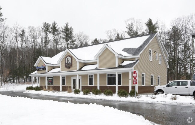
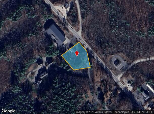
Property Record
89 Route 236, Kittery, ME 03904

NEARBY LISTINGS FOR SALE OR LEASE
Property Detail
89 Route 236
KITT-000028-000000-000014-000002
Peter J Paul
Officebuilding
York
X
Maine
23031C0707G
14-2
2024
1.38 AC
2024
York County
038002
Portland/South Portland
4,498 SF
Portland-South Portland, ME
DEMOGRAPHICS near 89 Route 236
1 Mile
3 Mile
5 Mile
2024 Total Population
1,582
18,640
41,448
2029 Population
1,663
19,595
43,434
Pop Growth 2024-2029
+ 5.12%
+ 5.12%
+ 4.79%
Average Age
45
44
45
2024 Total Households
663
8,470
18,559
HH Growth 2024-2029
+ 5.13%
+ 5.10%
+ 4.75%
Median Household Inc
$75,329
$85,702
$98,277
Avg Household Size
2.30
2.10
2.20
2024 Avg HH Vehicles
2.00
2.00
2.00
Median Home Value
$375,365
$418,522
$494,788
Median Year Built
1977
1976
1967
Nearby Places
Map Layers
Map Styles
 Street
 Aerial
- Restaurants
- Banks
- Shops
- Fitness
- Groceries
PUBLIC TRANSPORTATION
COMMUTER RAIL
Dover (Downeaster - Amtrak)
DRIVE
WALK
Distance
Dover (Downeaster - Amtrak)
18 min
9.3 mi
AIRPORT
Portsmouth International at Pease
DRIVE
WALK
Distance
Portsmouth International at Pease
12 min
6.0 mi
Freight Ports
Portland, ME
DRIVE
WALK
Distance
Portland, ME
60 min
50.1 mi
Nearby Properties
Address
Land Use
TOTAL SIZE
Lot Size
Zoning
Address
Land Use
TOTAL SIZE
Lot Size
Zoning
58.25 AC
COMM
Address
Land Use
TOTAL SIZE
Lot Size
Zoning
98.73 AC
C/I
Address
Land Use
TOTAL SIZE
Lot Size
Zoning
152,028 SF
CD5
Address
Land Use
TOTAL SIZE
Lot Size
Zoning
1,575 SF
52.95 AC
COMM
Address
Land Use
TOTAL SIZE
Lot Size
Zoning
22.33 AC
MU-N
Address
Land Use
TOTAL SIZE
Lot Size
Zoning
102,617 SF
1.27 AC
CD5
Address
Land Use
TOTAL SIZE
Lot Size
Zoning
136,711 SF
1.85 AC
CD5
Address
Land Use
TOTAL SIZE
Lot Size
Zoning
19.26 AC
G1
Address
Land Use
TOTAL SIZE
Lot Size
Zoning
11.30 AC
G1
Address
Land Use
TOTAL SIZE
Lot Size
Zoning
86,293 SF
0.64 AC
CD5
Address
Land Use
TOTAL SIZE
Lot Size
Zoning
15.94 AC
G1
Address
Land Use
TOTAL SIZE
Lot Size
Zoning
48.95 AC
WIND
Address
Land Use
TOTAL SIZE
Lot Size
Zoning
3.78 AC
COMM
Address
Land Use
TOTAL SIZE
Lot Size
Zoning
64.76 AC
WIND
Address
Land Use
TOTAL SIZE
Lot Size
Zoning
18.49 AC
GRB
Address
Land Use
TOTAL SIZE
Lot Size
Zoning
23.29 AC
G1
Address
Land Use
TOTAL SIZE
Lot Size
Zoning
77,523 SF
CD5
Address
Land Use
TOTAL SIZE
Lot Size
Zoning
69,457 SF
0.98 AC
CD5
Address
Land Use
TOTAL SIZE
Lot Size
Zoning
3.97 AC
SD
Address
Land Use
TOTAL SIZE
Lot Size
Zoning
58,070 SF
0.53 AC
CD4
Address
Land Use
TOTAL SIZE
Lot Size
Zoning
84,273 SF
13.61 AC
C-1
Address
Land Use
TOTAL SIZE
Lot Size
Zoning
9,060 SF
7.02 AC
IND
Address
Land Use
TOTAL SIZE
Lot Size
Zoning
39,780 SF
8.82 AC
OR
Address
Land Use
TOTAL SIZE
Lot Size
Zoning
5.45 AC
OFF
Address
Land Use
TOTAL SIZE
Lot Size
Zoning
117,028 SF
12.25 AC
G1
Address
Land Use
TOTAL SIZE
Lot Size
Zoning
238,513 SF
31.02 AC
COMM
Address
Land Use
TOTAL SIZE
Lot Size
Zoning
81,964 SF
6.99 AC
OR
Address
Land Use
TOTAL SIZE
Lot Size
Zoning
40,736 SF
14.82 AC
C-1
Address
Land Use
TOTAL SIZE
Lot Size
Zoning
101,643 SF
8.41 AC
OFF
Address
Land Use
TOTAL SIZE
Lot Size
Zoning
278,670 SF
1.86 AC
M
The World's #1 Commercial Real Estate Marketplace
Connect with us
© 2025 CoStar Group
The information above has been obtained from sources believed reliable. While we do not doubt its accuracy we have not verified it and make no guarantee, warranty or representation about it. It is your responsibility to independently confirm its accuracy and completeness. Any projections, opinions, assumptions, or estimates used are for example only and do not represent the current or future performance of the property. The value of this transaction to you depends on tax and other factors which should be evaluated by your tax, financial, and legal advisors. You and your advisors should conduct a careful, independent investigation of the property to determine to your satisfaction the suitability of the property for your needs.