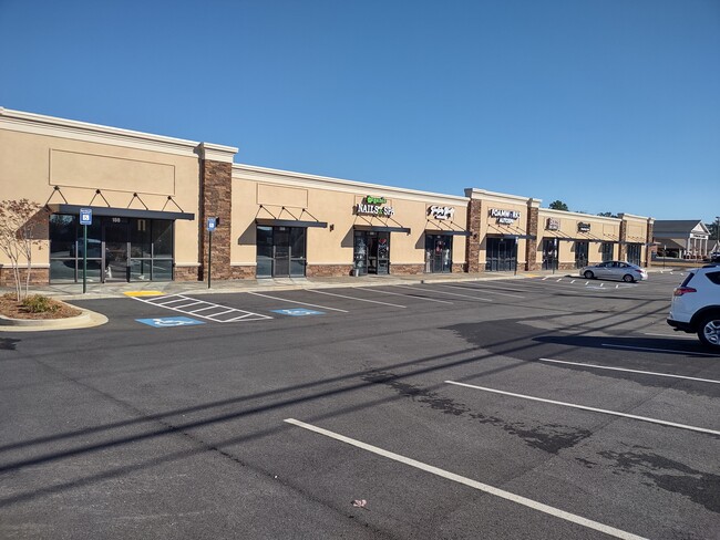
Property Record
89 Sandy Run Ln, Warner Robins, GA 31088
NEARBY LISTINGS FOR SALE OR LEASE
Property Detail
89 Sandy Run Ln
Warner Robins, GA
Sandy Pointe S/D
0W1490008000
LOT 8 SANDY POINTE S/D 47/11TH
Communitycenter
Houston
X
Georgia
13289C0200B
8
2024
1.41 AC
2024
Perry/Warner Robins
021119
Other Market Areas
2,016 SF
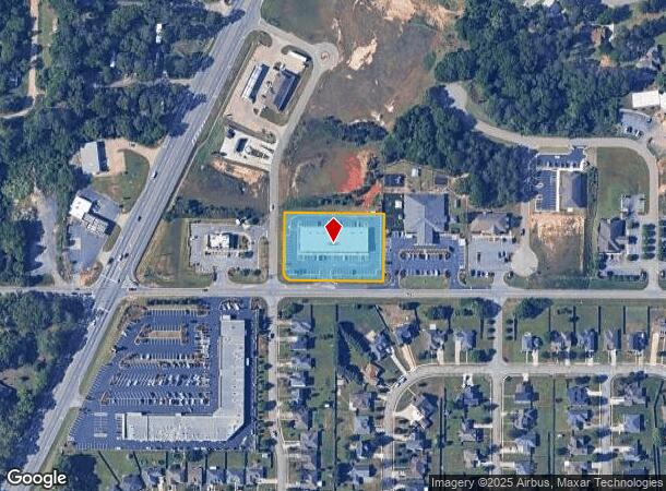
DEMOGRAPHICS near 89 Sandy Run Ln
1 Mile
3 Mile
5 Mile
2024 Total Population
2,505
28,582
77,984
2029 Population
2,757
31,486
85,727
Pop Growth 2024-2029
+ 10.06%
+ 10.16%
+ 9.93%
Average Age
41
37
37
2024 Total Households
969
10,716
29,425
HH Growth 2024-2029
+ 9.80%
+ 10.05%
+ 9.75%
Median Household Inc
$133,946
$85,020
$74,602
Avg Household Size
2.60
2.60
2.60
2024 Avg HH Vehicles
3.00
2.00
2.00
Median Home Value
$292,455
$202,625
$174,518
Median Year Built
2001
1992
1989
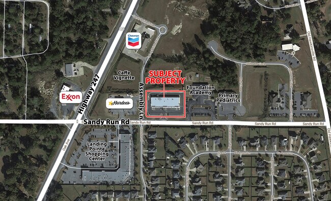
Nearby Places
Map Layers
Map Styles
 Street
 Aerial
- Restaurants
- Banks
- Shops
- Fitness
- Groceries
SALE & LEASE HISTORY
LISTING DATE
SALE/LEASE

May 04, 2021
For Lease
Nearby Properties
Address
Land Use
TOTAL SIZE
Lot Size
Zoning
Address
Land Use
TOTAL SIZE
Lot Size
Zoning
100,320 SF
26.91 AC
C2
Address
Land Use
TOTAL SIZE
Lot Size
Zoning
178,400 SF
49.03 AC
R2
Address
Land Use
TOTAL SIZE
Lot Size
Zoning
3,199 SF
41.42 AC
R4
Address
Land Use
TOTAL SIZE
Lot Size
Zoning
842,179 SF
101.75 AC
M2
Address
Land Use
TOTAL SIZE
Lot Size
Zoning
139,756 SF
34.14 AC
R1
Address
Land Use
TOTAL SIZE
Lot Size
Zoning
134,400 SF
22.43 AC
R1
Address
Land Use
TOTAL SIZE
Lot Size
Zoning
106,055 SF
35.17 AC
R1
Address
Land Use
TOTAL SIZE
Lot Size
Zoning
210,408 SF
47.18 AC
C2
Address
Land Use
TOTAL SIZE
Lot Size
Zoning
19,200 SF
14.70 AC
R4
Address
Land Use
TOTAL SIZE
Lot Size
Zoning
17,832 SF
13.60 AC
R4
Address
Land Use
TOTAL SIZE
Lot Size
Zoning
120,000 SF
19.03 AC
R3
Address
Land Use
TOTAL SIZE
Lot Size
Zoning
100,000 SF
12.12 AC
RAG
Address
Land Use
TOTAL SIZE
Lot Size
Zoning
48,462 SF
5.54 AC
C2
Address
Land Use
TOTAL SIZE
Lot Size
Zoning
25,062 SF
R4
Address
Land Use
TOTAL SIZE
Lot Size
Zoning
25,062 SF
R4
Address
Land Use
TOTAL SIZE
Lot Size
Zoning
71,434 SF
10.58 AC
R2
Address
Land Use
TOTAL SIZE
Lot Size
Zoning
5,412 SF
4.98 AC
R4
Address
Land Use
TOTAL SIZE
Lot Size
Zoning
102,400 SF
28.22 AC
M2
Address
Land Use
TOTAL SIZE
Lot Size
Zoning
6,988 SF
3.66 AC
R4
Address
Land Use
TOTAL SIZE
Lot Size
Zoning
60,126 SF
13.08 AC
C2
Address
Land Use
TOTAL SIZE
Lot Size
Zoning
40,050 SF
7.63 AC
M1
Address
Land Use
TOTAL SIZE
Lot Size
Zoning
94,091 SF
11.23 AC
C2
Address
Land Use
TOTAL SIZE
Lot Size
Zoning
31,198 SF
40.66 AC
R2
Address
Land Use
TOTAL SIZE
Lot Size
Zoning
19,200 SF
8.51 AC
R1
Address
Land Use
TOTAL SIZE
Lot Size
Zoning
26,928 SF
5.74 AC
R4
Address
Land Use
TOTAL SIZE
Lot Size
Zoning
29,950 SF
4.97 AC
R1
Address
Land Use
TOTAL SIZE
Lot Size
Zoning
34,337 SF
3.89 AC
M1
Address
Land Use
TOTAL SIZE
Lot Size
Zoning
12,791 SF
15.66 AC
C1
Address
Land Use
TOTAL SIZE
Lot Size
Zoning
40,520 SF
6.97 AC
M2
Address
Land Use
TOTAL SIZE
Lot Size
Zoning
4,830 SF
3.83 AC
M1
The World's #1 Commercial Real Estate Marketplace
Connect with us
© 2025 CoStar Group
The information above has been obtained from sources believed reliable. While we do not doubt its accuracy we have not verified it and make no guarantee, warranty or representation about it. It is your responsibility to independently confirm its accuracy and completeness. Any projections, opinions, assumptions, or estimates used are for example only and do not represent the current or future performance of the property. The value of this transaction to you depends on tax and other factors which should be evaluated by your tax, financial, and legal advisors. You and your advisors should conduct a careful, independent investigation of the property to determine to your satisfaction the suitability of the property for your needs.