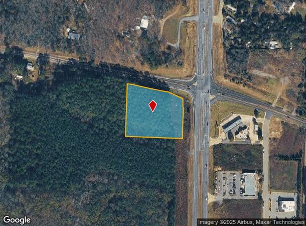
Property Record
89 W Highway N Hwy, Cabot, AR 72023

NEARBY LISTINGS FOR SALE OR LEASE
Property Detail
89 W Highway N Hwy
11R-016-00-001-01
PT NE NE MPDA COM NE COR NE NE TH S02*1849W 591.71FT N87*2344W 143.79 FT TO POB TH N87*2347W 369.15 FT N02*0851E 348.15 FT S72*5830E ALONG R/W 373.77 FT S02*2104E ALONG SAID R/W 85.89 FT S01*4517W ALONG SAID R/W 169.5 FT TO POB CON
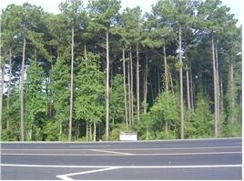
Commercialacreage
Pulaski
X
Arkansas
05119C0205G
2.54 AC
2025
Outlying Pulaski County
2025
Little Rock/N Little Rock
020204
Little Rock-North Little Rock-Conway, AR
DEMOGRAPHICS near 89 W Highway N Hwy
1 Mile
3 Mile
5 Mile
2024 Total Population
664
12,687
34,294
2029 Population
678
13,085
35,418
Pop Growth 2024-2029
+ 2.11%
+ 3.14%
+ 3.28%
Average Age
42
39
39
2024 Total Households
246
4,904
13,016
HH Growth 2024-2029
+ 2.03%
+ 3.10%
+ 3.20%
Median Household Inc
$85,087
$61,619
$65,489
Avg Household Size
2.70
2.50
2.60
2024 Avg HH Vehicles
2.00
2.00
2.00
Median Home Value
$176,922
$162,248
$173,403
Median Year Built
1993
1994
1997
Nearby Places
Map Layers
Map Styles
 Street
 Aerial
- Restaurants
- Banks
- Shops
- Fitness
- Groceries
PUBLIC TRANSPORTATION
AIRPORT
Bill and Hillary Clinton Ntl/Adams Field
DRIVE
WALK
Distance
Bill and Hillary Clinton Ntl/Adams Field
30 min
24.5 mi
Nearby Properties
Address
Land Use
TOTAL SIZE
Lot Size
Zoning
Address
Land Use
TOTAL SIZE
Lot Size
Zoning
150,958 SF
10.19 AC
Address
Land Use
TOTAL SIZE
Lot Size
Zoning
226,799 SF
21.73 AC
Address
Land Use
TOTAL SIZE
Lot Size
Zoning
199,090 SF
9.82 AC
Address
Land Use
TOTAL SIZE
Lot Size
Zoning
143,892 SF
8.65 AC
Address
Land Use
TOTAL SIZE
Lot Size
Zoning
44,675 SF
4.43 AC
Address
Land Use
TOTAL SIZE
Lot Size
Zoning
109,648 SF
9.05 AC
Address
Land Use
TOTAL SIZE
Lot Size
Zoning
134,045 SF
12.15 AC
Address
Land Use
TOTAL SIZE
Lot Size
Zoning
141,490 SF
9.97 AC
Address
Land Use
TOTAL SIZE
Lot Size
Zoning
184,011 SF
15 AC
Address
Land Use
TOTAL SIZE
Lot Size
Zoning
25,956 SF
3.22 AC
Address
Land Use
TOTAL SIZE
Lot Size
Zoning
62,250 SF
8.59 AC
Address
Land Use
TOTAL SIZE
Lot Size
Zoning
13,302 SF
0.71 AC
Address
Land Use
TOTAL SIZE
Lot Size
Zoning
50,550 SF
8.98 AC
Address
Land Use
TOTAL SIZE
Lot Size
Zoning
60,322 SF
10 AC
Address
Land Use
TOTAL SIZE
Lot Size
Zoning
104,795 SF
12.07 AC
Address
Land Use
TOTAL SIZE
Lot Size
Zoning
51,992 SF
2.82 AC
Address
Land Use
TOTAL SIZE
Lot Size
Zoning
10,408 SF
6.25 AC
Address
Land Use
TOTAL SIZE
Lot Size
Zoning
91,224 SF
8.39 AC
Address
Land Use
TOTAL SIZE
Lot Size
Zoning
9,750 SF
1.62 AC
Address
Land Use
TOTAL SIZE
Lot Size
Zoning
41,864 SF
5.22 AC
Address
Land Use
TOTAL SIZE
Lot Size
Zoning
41,826 SF
54.90 AC
Address
Land Use
TOTAL SIZE
Lot Size
Zoning
28,943 SF
3.39 AC
Address
Land Use
TOTAL SIZE
Lot Size
Zoning
18,550 SF
11.37 AC
Address
Land Use
TOTAL SIZE
Lot Size
Zoning
29,416 SF
3.15 AC
Address
Land Use
TOTAL SIZE
Lot Size
Zoning
99,270 SF
1.38 AC
Address
Land Use
TOTAL SIZE
Lot Size
Zoning
9,036 SF
4.68 AC
Address
Land Use
TOTAL SIZE
Lot Size
Zoning
8,450 SF
0.62 AC
Address
Land Use
TOTAL SIZE
Lot Size
Zoning
55,587 SF
3 AC
Address
Land Use
TOTAL SIZE
Lot Size
Zoning
46,936 SF
7.70 AC
Address
Land Use
TOTAL SIZE
Lot Size
Zoning
14,400 SF
3.66 AC
The World's #1 Commercial Real Estate Marketplace
Connect with us
© 2026 CoStar Group
The information above has been obtained from sources believed reliable. While we do not doubt its accuracy we have not verified it and make no guarantee, warranty or representation about it. It is your responsibility to independently confirm its accuracy and completeness. Any projections, opinions, assumptions, or estimates used are for example only and do not represent the current or future performance of the property. The value of this transaction to you depends on tax and other factors which should be evaluated by your tax, financial, and legal advisors. You and your advisors should conduct a careful, independent investigation of the property to determine to your satisfaction the suitability of the property for your needs.