Property Record
890 E Hobsonway, Blythe, CA 92225
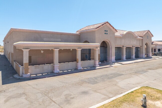

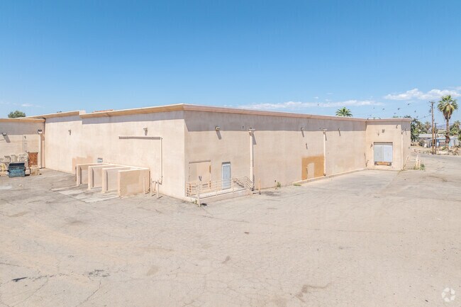
Property Detail
890 E Hobsonway
Riverside-San Bernardino-Ontario, CA
2.84 ACRES IN PAR 3 PM 163/074 PM 25790
854-020-017
Riverside
Storebuilding
California
D Areas with possible but undetermined flood hazards.
3
2024
2.84 AC
2025
Riverside Outlying
046200
Inland Empire (California)
31,167 SF
NEARBY LISTINGS FOR SALE OR LEASE
DEMOGRAPHICS near 890 E Hobsonway
1 mile
3 mile
5 mile
2025 Total Population
8,286
14,296
16,573
2030 Population
8,724
15,152
17,560
Pop Growth 2025-2030
+ 5.29%
+ 5.99%
+ 5.96%
Average Age
36
37
38
2025 Total Households
2,942
5,051
5,961
HH Growth 2025-2030
+ 4.89%
+ 5.62%
+ 5.60%
Median Household Inc
$49,236
$53,333
$53,341
Avg Household Size
2.80
2.80
2.70
2025 Avg HH Vehicles
2.00
2.00
2.00
Median Home Value
$158,702
$190,054
$191,640
Median Year Built
1977
1979
1981
Nearby Places
Map Layers
Map Styles
 Street
 Aerial
Transit
 Traffic
 Biking
Places
Listings with unknown addresses are not visible on the map
- Restaurants
- Banks
- Shops
- Fitness
- Groceries
SALE & LEASE HISTORY
LISTING DATE
SALE/LEASE

Nov 26, 2018
For Lease
May 04, 2017
For Lease
Jun 25, 2021
For Sale
Apr 30, 2024
For Sale
Nearby Properties
Address
Land Use
TOTAL SIZE
Lot Size
Zoning
Address
Land Use
TOTAL SIZE
Lot Size
Zoning
93,469 SF
18.22 AC
Address
Land Use
TOTAL SIZE
Lot Size
Zoning
47,704 SF
3.01 AC
I-G
Address
Land Use
TOTAL SIZE
Lot Size
Zoning
95,108 SF
3.33 AC
Address
Land Use
TOTAL SIZE
Lot Size
Zoning
28,146 SF
1.44 AC
C2
Address
Land Use
TOTAL SIZE
Lot Size
Zoning
17,340 SF
1.76 AC
C2
Address
Land Use
TOTAL SIZE
Lot Size
Zoning
52,386 SF
2.48 AC
Address
Land Use
TOTAL SIZE
Lot Size
Zoning
47,352 SF
3.99 AC
C2
Address
Land Use
TOTAL SIZE
Lot Size
Zoning
16,868 SF
4.07 AC
Address
Land Use
TOTAL SIZE
Lot Size
Zoning
90,912 SF
10.83 AC
C-G
Address
Land Use
TOTAL SIZE
Lot Size
Zoning
32,011 SF
4.61 AC
R3
Address
Land Use
TOTAL SIZE
Lot Size
Zoning
29,074 SF
2.06 AC
Address
Land Use
TOTAL SIZE
Lot Size
Zoning
38,162 SF
1.65 AC
Address
Land Use
TOTAL SIZE
Lot Size
Zoning
234.91 AC
MIX
Address
Land Use
TOTAL SIZE
Lot Size
Zoning
55,900 SF
4.92 AC
C1
Address
Land Use
TOTAL SIZE
Lot Size
Zoning
38,675 SF
5.71 AC
Address
Land Use
TOTAL SIZE
Lot Size
Zoning
2.54 AC
Address
Land Use
TOTAL SIZE
Lot Size
Zoning
39,746 SF
3.70 AC
C2
Address
Land Use
TOTAL SIZE
Lot Size
Zoning
42,640 SF
2.92 AC
R3
Address
Land Use
TOTAL SIZE
Lot Size
Zoning
48,254 SF
3.23 AC
Address
Land Use
TOTAL SIZE
Lot Size
Zoning
58,520 SF
4.18 AC
C2
Address
Land Use
TOTAL SIZE
Lot Size
Zoning
4.89 AC
MM
Address
Land Use
TOTAL SIZE
Lot Size
Zoning
67,165 SF
4.61 AC
M1
Address
Land Use
TOTAL SIZE
Lot Size
Zoning
2,571 SF
0.49 AC
Address
Land Use
TOTAL SIZE
Lot Size
Zoning
12,228 SF
1.27 AC
C2
Address
Land Use
TOTAL SIZE
Lot Size
Zoning
54,418 SF
3.14 AC
R3
Address
Land Use
TOTAL SIZE
Lot Size
Zoning
3,860 SF
1.72 AC
Address
Land Use
TOTAL SIZE
Lot Size
Zoning
33,212 SF
2.05 AC
C2
Address
Land Use
TOTAL SIZE
Lot Size
Zoning
78.48 AC
A210
Address
Land Use
TOTAL SIZE
Lot Size
Zoning
22,580 SF
4.79 AC
PD
The World's #1 Commercial Real Estate Marketplace
Connect with us
© 2026 CoStar Group
The information above has been obtained from sources believed reliable. While we do not doubt its accuracy we have not verified it and make no guarantee, warranty or representation about it. It is your responsibility to independently confirm its accuracy and completeness. Any projections, opinions, assumptions, or estimates used are for example only and do not represent the current or future performance of the property. The value of this transaction to you depends on tax and other factors which should be evaluated by your tax, financial, and legal advisors. You and your advisors should conduct a careful, independent investigation of the property to determine to your satisfaction the suitability of the property for your needs.