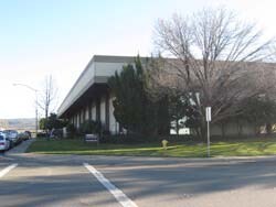
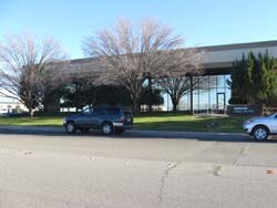
Property Record
890 Fortress St, Chico, CA 95973


Property Detail
890 Fortress St
047-560-018-000
890 FORTRESS ST
Industrialgeneral
Butte
AM
California
B and X Area of moderate flood hazard, usually the area between the limits of the 100-year and 500-year floods.
4.42 AC
2024
Redding/Chico
2025
Other Market Areas
001400
Chico, CA
29,131 SF
NEARBY LISTINGS FOR SALE OR LEASE
DEMOGRAPHICS near 890 Fortress St
1 mile
3 mile
5 mile
2025 Total Population
36
32,584
80,915
2030 Population
35
32,229
79,337
Pop Growth 2025-2030
(2.78%)
(1.09%)
(1.95%)
Average Age
42
38
37
2025 Total Households
13
13,182
32,655
HH Growth 2025-2030
0.00%
(1.37%)
(2.17%)
Median Household Inc
$95,833
$78,420
$71,166
Avg Household Size
2.50
2.40
2.30
2025 Avg HH Vehicles
3.00
2.00
2.00
Median Home Value
$799,999
$467,624
$485,588
Median Year Built
1988
1987
1982
Nearby Places
Map Layers
Map Styles
 Street
 Aerial
Layers
 Traffic
 Biking
Places
Listings with unknown addresses are not visible on the map
- Restaurants
- Banks
- Shops
- Fitness
- Groceries
PUBLIC TRANSPORTATION
COMMUTER RAIL
Chico Amtrak (Coast Starlight - Amtrak)
Drive
Walk
Distance
Chico Amtrak (Coast Starlight - Amtrak)
15 min
7.2 mi
Freight Ports
Port of Stockton
Drive
Walk
Distance
Port of Stockton
168 min
136.3 mi
Nearby Properties
Address
Land Use
TOTAL SIZE
Lot Size
Zoning
Address
Land Use
TOTAL SIZE
Lot Size
Zoning
12.63 AC
R1
Address
Land Use
TOTAL SIZE
Lot Size
Zoning
8.55 AC
R3
Address
Land Use
TOTAL SIZE
Lot Size
Zoning
190,996 SF
7.94 AC
R3
Address
Land Use
TOTAL SIZE
Lot Size
Zoning
8,008 SF
8.79 AC
Address
Land Use
TOTAL SIZE
Lot Size
Zoning
9,784 SF
3.97 AC
R1
Address
Land Use
TOTAL SIZE
Lot Size
Zoning
126,476 SF
6.75 AC
R3
Address
Land Use
TOTAL SIZE
Lot Size
Zoning
247,613 SF
10.77 AC
CR
Address
Land Use
TOTAL SIZE
Lot Size
Zoning
83,886 SF
4.55 AC
Address
Land Use
TOTAL SIZE
Lot Size
Zoning
142,712 SF
7.24 AC
Address
Land Use
TOTAL SIZE
Lot Size
Zoning
132,768 SF
9.65 AC
R3
Address
Land Use
TOTAL SIZE
Lot Size
Zoning
123,494 SF
6.84 AC
R3
Address
Land Use
TOTAL SIZE
Lot Size
Zoning
2,248 SF
7.90 AC
R3
Address
Land Use
TOTAL SIZE
Lot Size
Zoning
42,630 SF
3.95 AC
CC
Address
Land Use
TOTAL SIZE
Lot Size
Zoning
5,776 SF
4.23 AC
Address
Land Use
TOTAL SIZE
Lot Size
Zoning
397,710 SF
18 AC
00
Address
Land Use
TOTAL SIZE
Lot Size
Zoning
52,449 SF
5.04 AC
CC
Address
Land Use
TOTAL SIZE
Lot Size
Zoning
78,398 SF
4.96 AC
SR3
Address
Land Use
TOTAL SIZE
Lot Size
Zoning
25,304 SF
5.41 AC
CC
Address
Land Use
TOTAL SIZE
Lot Size
Zoning
98,112 SF
6.86 AC
Address
Land Use
TOTAL SIZE
Lot Size
Zoning
7,260 SF
9.67 AC
R3
Address
Land Use
TOTAL SIZE
Lot Size
Zoning
71,197 SF
7.30 AC
R3
Address
Land Use
TOTAL SIZE
Lot Size
Zoning
68,704 SF
2.29 AC
Address
Land Use
TOTAL SIZE
Lot Size
Zoning
876 SF
3.35 AC
R3
Address
Land Use
TOTAL SIZE
Lot Size
Zoning
49,291 SF
2.53 AC
OR
Address
Land Use
TOTAL SIZE
Lot Size
Zoning
31,570 SF
2.58 AC
Address
Land Use
TOTAL SIZE
Lot Size
Zoning
49,527 SF
2.92 AC
R2
Address
Land Use
TOTAL SIZE
Lot Size
Zoning
36,806 SF
2.57 AC
OR
Address
Land Use
TOTAL SIZE
Lot Size
Zoning
87,759 SF
5.89 AC
CITY
Address
Land Use
TOTAL SIZE
Lot Size
Zoning
63,586 SF
2.70 AC
00
The World's #1 Commercial Real Estate Marketplace
Connect with us
© 2026 CoStar Group
The information above has been obtained from sources believed reliable. While we do not doubt its accuracy we have not verified it and make no guarantee, warranty or representation about it. It is your responsibility to independently confirm its accuracy and completeness. Any projections, opinions, assumptions, or estimates used are for example only and do not represent the current or future performance of the property. The value of this transaction to you depends on tax and other factors which should be evaluated by your tax, financial, and legal advisors. You and your advisors should conduct a careful, independent investigation of the property to determine to your satisfaction the suitability of the property for your needs.