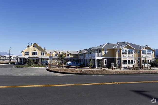
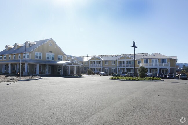
Property Record
890 N Refugio Rd, Santa Ynez, CA 93460
NEARBY LISTINGS FOR SALE OR LEASE
-
-
View all Santa Ynez listings for sale on LoopNet.com
Property Detail
890 N Refugio Rd
141-380-046
Santa Barbara
Apartment
California
X
2
06083C1076G
3 AC
2024
Santa Ynez
2025
Santa Barbara/Sta Maria/Goleta
001908
Santa Maria-Santa Barbara, CA
DEMOGRAPHICS near 890 N Refugio Rd
1 Mile
3 Mile
5 Mile
2024 Total Population
2,317
10,256
13,683
2029 Population
2,225
9,928
13,168
Pop Growth 2024-2029
(3.97%)
(3.20%)
(3.76%)
Average Age
46
46
46
2024 Total Households
902
4,004
5,315
HH Growth 2024-2029
(4.10%)
(3.35%)
(3.95%)
Median Household Inc
$124,341
$117,812
$116,182
Avg Household Size
2.50
2.50
2.40
2024 Avg HH Vehicles
3.00
2.00
2.00
Median Home Value
$1,047,187
$1,003,462
$1,000,431
Median Year Built
1973
1979
1979
Nearby Places
Map Layers
Map Styles
 Street
 Aerial
- Restaurants
- Banks
- Shops
- Fitness
- Groceries
PUBLIC TRANSPORTATION
AIRPORT
Santa Barbara Municipal
DRIVE
WALK
Distance
Santa Barbara Municipal
61 min
34.4 mi
Freight Ports
The Port of Hueneme
DRIVE
WALK
Distance
The Port of Hueneme
96 min
70.6 mi
Nearby Properties
Address
Land Use
TOTAL SIZE
Lot Size
Zoning
Address
Land Use
TOTAL SIZE
Lot Size
Zoning
5.10 AC
Address
Land Use
TOTAL SIZE
Lot Size
Zoning
10.27 AC
Address
Land Use
TOTAL SIZE
Lot Size
Zoning
2.44 AC
Address
Land Use
TOTAL SIZE
Lot Size
Zoning
14,794 SF
34.82 AC
AGII40
Address
Land Use
TOTAL SIZE
Lot Size
Zoning
2.55 AC
Address
Land Use
TOTAL SIZE
Lot Size
Zoning
1.54 AC
Address
Land Use
TOTAL SIZE
Lot Size
Zoning
4.35 AC
C2
Address
Land Use
TOTAL SIZE
Lot Size
Zoning
8,775 SF
71.38 AC
AGII100
Address
Land Use
TOTAL SIZE
Lot Size
Zoning
0.04 AC
Address
Land Use
TOTAL SIZE
Lot Size
Zoning
52 AC
AGII40
Address
Land Use
TOTAL SIZE
Lot Size
Zoning
3.08 AC
Address
Land Use
TOTAL SIZE
Lot Size
Zoning
1.04 AC
Address
Land Use
TOTAL SIZE
Lot Size
Zoning
0.79 AC
Address
Land Use
TOTAL SIZE
Lot Size
Zoning
3.34 AC
Address
Land Use
TOTAL SIZE
Lot Size
Zoning
136.10 AC
AGII40
Address
Land Use
TOTAL SIZE
Lot Size
Zoning
0.35 AC
Address
Land Use
TOTAL SIZE
Lot Size
Zoning
1.73 AC
Address
Land Use
TOTAL SIZE
Lot Size
Zoning
15.19 AC
AGI10
Address
Land Use
TOTAL SIZE
Lot Size
Zoning
0.40 AC
Address
Land Use
TOTAL SIZE
Lot Size
Zoning
37.06 AC
AGI40
Address
Land Use
TOTAL SIZE
Lot Size
Zoning
413.83 AC
AGII100
Address
Land Use
TOTAL SIZE
Lot Size
Zoning
1.24 AC
Address
Land Use
TOTAL SIZE
Lot Size
Zoning
5,093 SF
40 AC
AGII40
Address
Land Use
TOTAL SIZE
Lot Size
Zoning
6,615 SF
49.67 AC
AGII100
Address
Land Use
TOTAL SIZE
Lot Size
Zoning
227.42 AC
AGII100
Address
Land Use
TOTAL SIZE
Lot Size
Zoning
0.91 AC
Address
Land Use
TOTAL SIZE
Lot Size
Zoning
0.86 AC
Address
Land Use
TOTAL SIZE
Lot Size
Zoning
2.62 AC
1E1
The World's #1 Commercial Real Estate Marketplace
Connect with us
© 2026 CoStar Group
The information above has been obtained from sources believed reliable. While we do not doubt its accuracy we have not verified it and make no guarantee, warranty or representation about it. It is your responsibility to independently confirm its accuracy and completeness. Any projections, opinions, assumptions, or estimates used are for example only and do not represent the current or future performance of the property. The value of this transaction to you depends on tax and other factors which should be evaluated by your tax, financial, and legal advisors. You and your advisors should conduct a careful, independent investigation of the property to determine to your satisfaction the suitability of the property for your needs.