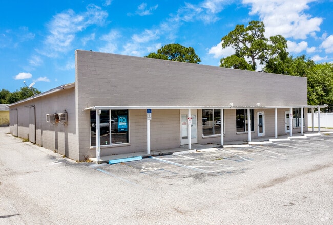
Property Record
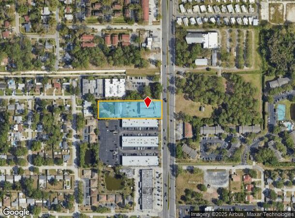
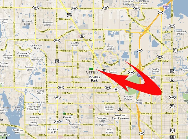
8900 49Th St N, Pinellas Park, FL 33782

NEARBY LISTINGS FOR SALE OR LEASE
Property Detail
8900 49Th St N
21-30-16-69822-400-5102
Pinellas Farms
Vehiclerentalsvehiclesales
PINELLAS FARMS SE 1/4, S 126FT(S) OF N 291FT(S) OF E 456FT(S) OF W 611FT(S) OF FARM 51
AE
Pinellas
12103C0202J
Florida
2024
1.32 AC
2025
Mid-Pinellas
024905
Tampa/St Petersburg
14,640 SF
Tampa-St. Petersburg-Clearwater, FL
DEMOGRAPHICS near 8900 49Th St N
1 Mile
3 Mile
5 Mile
2024 Total Population
15,862
83,292
257,081
2029 Population
15,930
83,522
257,485
Pop Growth 2024-2029
+ 0.43%
+ 0.28%
+ 0.16%
Average Age
45
44
44
2024 Total Households
6,855
36,031
116,329
HH Growth 2024-2029
+ 0.39%
+ 0.26%
+ 0.02%
Median Household Inc
$48,566
$52,442
$58,707
Avg Household Size
2.20
2.20
2.10
2024 Avg HH Vehicles
2.00
2.00
2.00
Median Home Value
$197,927
$209,565
$226,090
Median Year Built
1973
1975
1975
Nearby Places
Map Layers
Map Styles
 Street
 Aerial
- Restaurants
- Banks
- Shops
- Fitness
- Groceries
PUBLIC TRANSPORTATION
AIRPORT
St Pete-Clearwater International
DRIVE
WALK
Distance
St Pete-Clearwater International
10 min
4.9 mi
Tampa International
DRIVE
WALK
Distance
Tampa International
27 min
17.6 mi
Sarasota/Bradenton International
DRIVE
WALK
Distance
Sarasota/Bradenton International
59 min
39.4 mi
Freight Ports
Port of Tampa Bay
DRIVE
WALK
Distance
Port of Tampa Bay
36 min
22.8 mi
SALE & LEASE HISTORY
LISTING DATE
SALE/LEASE

Sep 24, 2016
For Lease
May 07, 2020
For Lease
Nearby Properties
Address
Land Use
TOTAL SIZE
Lot Size
Zoning
Address
Land Use
TOTAL SIZE
Lot Size
Zoning
372,013 SF
10.10 AC
Address
Land Use
TOTAL SIZE
Lot Size
Zoning
447,664 SF
34.44 AC
Address
Land Use
TOTAL SIZE
Lot Size
Zoning
171,420 SF
300.24 AC
M1
Address
Land Use
TOTAL SIZE
Lot Size
Zoning
346,420 SF
17.95 AC
Address
Land Use
TOTAL SIZE
Lot Size
Zoning
372,436 SF
22.30 AC
Address
Land Use
TOTAL SIZE
Lot Size
Zoning
382,389 SF
13.62 AC
Address
Land Use
TOTAL SIZE
Lot Size
Zoning
404,063 SF
12.98 AC
Address
Land Use
TOTAL SIZE
Lot Size
Zoning
404,899 SF
35.35 AC
Address
Land Use
TOTAL SIZE
Lot Size
Zoning
358,681 SF
11.70 AC
Address
Land Use
TOTAL SIZE
Lot Size
Zoning
240,736 SF
58.40 AC
Address
Land Use
TOTAL SIZE
Lot Size
Zoning
402,681 SF
18.40 AC
Address
Land Use
TOTAL SIZE
Lot Size
Zoning
324,579 SF
16.97 AC
Address
Land Use
TOTAL SIZE
Lot Size
Zoning
300,546 SF
6.49 AC
Address
Land Use
TOTAL SIZE
Lot Size
Zoning
294,478 SF
44.79 AC
M1
Address
Land Use
TOTAL SIZE
Lot Size
Zoning
423,776 SF
20.91 AC
Address
Land Use
TOTAL SIZE
Lot Size
Zoning
240,392 SF
58.32 AC
Address
Land Use
TOTAL SIZE
Lot Size
Zoning
206,685 SF
16.75 AC
RPD5
Address
Land Use
TOTAL SIZE
Lot Size
Zoning
267,649 SF
17.86 AC
Address
Land Use
TOTAL SIZE
Lot Size
Zoning
258,722 SF
11.04 AC
Address
Land Use
TOTAL SIZE
Lot Size
Zoning
281,993 SF
85.13 AC
Address
Land Use
TOTAL SIZE
Lot Size
Zoning
159,073 SF
3.02 AC
Address
Land Use
TOTAL SIZE
Lot Size
Zoning
193,194 SF
13.53 AC
Address
Land Use
TOTAL SIZE
Lot Size
Zoning
360,137 SF
37.64 AC
AE
Address
Land Use
TOTAL SIZE
Lot Size
Zoning
211,684 SF
14.48 AC
M1
Address
Land Use
TOTAL SIZE
Lot Size
Zoning
393,795 SF
31.97 AC
M1
Address
Land Use
TOTAL SIZE
Lot Size
Zoning
172,600 SF
20.57 AC
Address
Land Use
TOTAL SIZE
Lot Size
Zoning
172,768 SF
15.05 AC
RPD20
Address
Land Use
TOTAL SIZE
Lot Size
Zoning
172,633 SF
25.24 AC
M1
Address
Land Use
TOTAL SIZE
Lot Size
Zoning
99,116 SF
20.60 AC
Address
Land Use
TOTAL SIZE
Lot Size
Zoning
125,218 SF
13.51 AC
The World's #1 Commercial Real Estate Marketplace
Connect with us
© 2025 CoStar Group
The information above has been obtained from sources believed reliable. While we do not doubt its accuracy we have not verified it and make no guarantee, warranty or representation about it. It is your responsibility to independently confirm its accuracy and completeness. Any projections, opinions, assumptions, or estimates used are for example only and do not represent the current or future performance of the property. The value of this transaction to you depends on tax and other factors which should be evaluated by your tax, financial, and legal advisors. You and your advisors should conduct a careful, independent investigation of the property to determine to your satisfaction the suitability of the property for your needs.